Pages

Saturday, December 22, 2012

The road to hell

In a previous post I asked if you could guess the author of these quotes:
"In every city throughout the country and in the sprawling suburbs surrounding the larger cities, traffic is piling up in swollen gasoline gullies, throttling industry, commerce and business; blocking street cleaning, fire and police apparatus; endangering the lives of men and women going to work, of mothers pushing baby carriages, and of children going to and from schools and playgrounds." 
"Fully half of all traffic deaths are due to speed. Cars have become more dangerous than wars." 
"The traffic accident cost to this nation is almost beyond belief." 
"[Regarding railroad crossings at grade] It is the highway, not the railroad--the car, not the train--which creates the hazard and must be primarily responsible for its [the grade crossing] removal."
It was a little unfair, as far as I can tell these quotes do not appear anywhere online except for the last one which appears verbatim in an FHWA manual for some reason.

Surprisingly, the quotes actually come from a little self-serving memoir/screed written in 1956 by none other than Robert Moses. Yes, that one.  His book was lined up next to Caro's magnum opus in the library, and I couldn't resist picking it up in addition for a little light holiday reading.
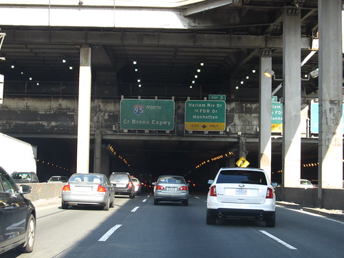
Trans-Manhattan Expressway (source)

Almost needless to say, Moses' methods at solving these problems drastically varies from current thinking. Here's a sample:
"Parkways were designed, built and protected for pleasant, careful driving. Cross traffic has been eliminated by attractive stone-faced bridges. Wide rights-of-way have been landscaped with native trees, flowing shrubs and evergreens. They have been developed as shoe-string parks with pavements for passenger cars only. All this is a useless expenditure for the speeders, who, at the rate they travel, cannot distinguish a rosebush from a bale of hay."
Can such a hardened political operator be so naïve as to think people would cruise slowly through isolated highways "just because" there was a bunch of pretty grass at the side? To be fair, it's not just Moses who thought this way, such parkways were popular all over, particularly in Boston. Of course, designers such as Olmsted at least had the fair excuse of being dead by the time speedy motorcars were prevalent. Sadly, a whole lot of urban parkland was turned into a stinking, congested, polluted car sewer by the time people thought better.
Cross Bronx Expressway (source)

Here's another few examples of Moses-style "solutions:"
"1. More drastic regulation of speed without regard to unrealistic, theoretically designed limits and political pressure for higher limits. 
2. Stopping the senseless advertising of high-speed motors as a basis of sales. 
3. An unrelenting campaign to acquaint the public with the cause and effect of accidents and especially the terrible danger of excessive speed."
So the roads would be designed and overbuilt for speed, but arbitrarily low limits should be enforced and politically backed. We know how well that "worked" out. And he seems to have favored government intrusion into cultural matters such as advertising, as if that would somehow deter Americans from wanting overpowered engines, if it could even pass constitutional muster (which I doubt).
"We need many additional regulations and restrictions governing the use of motor cars, not only to make them safer but to facilitate their movement and increase their usefulness to the community. Tighter zoning requirements would be enormously helpful. These cannot constitutionally be made retroactive, but they can be extended and enforced on new structure and the rebuilding of old ones, so as to require offstreet loading and unloading facilities and parking spaces for a reasonable number of cars on the premises."
Well, we did get safer cars since 1956. But we also got the "tighter zoning requirements" and that has been an unmitigated disaster for cities, turning so many of them into poor simulacra of bland suburbia that people fled in masses for actual suburbia.
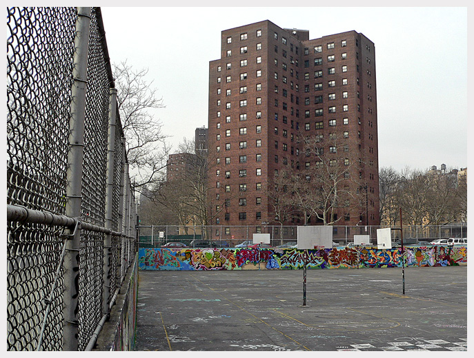
G.W. Carver Houses in Spanish Harlem (source)

But the real kicker is this one, where he rants against "extremists" who,
"...demand that in city centers, including residential as well as business districts, all private cars be kept out, that we cut in half the present number of taxis, that no parking, even with meter regulations, be permitted, and that we abandon all tall buildings for low horizontal structures on large garden plots. Dull, worn-out officials and irresponsible planners join in such proposals. But the process of change must be evolutionary and in charge of those whose aim is to modernize not revolutionize, to preserve values, not destroy them."
I think we can safely agree that banning private cars, and tall buildings -- in favor of large garden plots with low buildings -- is a bad idea. But, oh, the chutzpah. This from the man who brought upon New York City the horrors of the superblock, tower-in-the-park style housing project. A city which, I might add, was in no danger of losing its tall buildings or cars. And finally, that he thought of himself as evolutionary, that he was preserving rather than destroying? To address that I'll add one final quote from Robert Caro, my favorite one so far, although there is plenty more to review (italics original):
Webster Ave in Tremont,
as seen from the Cross Bronx (source)
When he [Moses] replied to protests about the hardships caused by his road-building programs, he generally replied that succeeding generations would be grateful. It was the end that counted, not the means. "You can't make an omelet without breaking eggs." Once, in a speech, he said:
"You can draw any kind of picture you like on a clean slate and indulge your every whim in the wilderness in laying out a New Delhi, Canberra or Brasília, but when you operate in an overbuilt metropolis, you have to hack your way with a meat ax."
The metaphor, like most Moses metaphors, was vivid. But it was incomplete. It expressed his philosophy, but it was not philosophy but feelings that dictated Moses' actions. He didn't just feel that he had to swing a meat ax. He loved to swing it.
Some preservationist he was.

Wednesday, December 19, 2012

Guess the author!

Don't have much time, but, came across a curious set of quotes in a book I was reading.
"In every city throughout the country and in the sprawling suburbs surrounding the larger cities, traffic is piling up in swollen gasoline gullies, throttling industry, commerce and business; blocking street cleaning, fire and police apparatus; endangering the lives of men and women going to work, of mothers pushing baby carriages, and of children going to and from schools and playgrounds." 
"Fully half of all traffic deaths are due to speed. Cars have become more dangerous than wars." 
"The traffic accident cost to this nation is almost beyond belief." 
"[Regarding railroad crossings at grade] It is the highway, not the railroad--the car, not the train--which creates the hazard and must be primarily responsible for its [the grade crossing] removal."
Anyone want to take a guess who wrote these words?

Monday, December 17, 2012

Replaying real-time bus data, expanded

About a month ago I posted a demo playback of the real-time data from Oct 11, 2011 for the 57 bus, taken from the MBTA Data Contest sample. Now I've expanded it to include all key bus routes, the Silver Line and the CT routes.

Real-time bus data playback
I've added a bunch of options as well, because displaying all of this information on one map can get very CPU intensive. Disabling the Stop Request/Door Open markers will ease up most of the burden. You can also select which routes to display using the checkboxes on the right, as well as toggling whether to show the lines of the bus routes.

The data take awhile to load so it's been split up into pieces which are loaded in the background while the simulation begins. A progress bar will be displayed on top until it finishes loading, but the map will start showing the bus data that have been already downloaded.

It's easy to forget the scale of the system when you ride the same way every day. Just take a look, as it starts early in the morning with a lone 28 bus, and then explodes with activity as it reaches the morning peak, until the entire map is crawling with buses. And these are only the key routes.

(Tested in Chrome and Firefox; IE users may be out of luck).

Friday, December 14, 2012

Government Center closure: shuttle routes

Since it seems we're looking at a closure of a major transfer station next September, let's look at some of the alternatives for replacing service. I'd prefer if they get the work done as soon as possible, say, 6 months instead of 24 months, but we'll still need some kind of shuttle service in the meantime.

They did not show the currently planned shuttle route between Bowdoin, Haymarket and State, but this is what I presume it will look like, operating clockwise:


View shuttle in a larger map

The roundtrip can probably be completed in about 10 minutes so this will likely use 2-3 buses, depending on how frequently they want to operate.

This planned route connects stations on the Blue, Orange, Green "C" and Green "E" lines but does not assist Blue/Red, Blue/"B", or Blue/"D" (except off-peak) connections. A shuttle between State and Park would assist every possible connection, however. But the T seems to have dismissed that possibility due to the one way roads and congestion around Park. I'm not sure what options they considered, but perhaps this was one of them:


View Park/State shuttle in a larger map

This loop would take about the same time as the previous option, maybe slightly less, but has the benefit of making all connections that don't involve the Silver Line. The drawbacks include the need to create a shuttle stop adjacent to the Park Street Church -- although there should be enough room -- and the possibility that a city bus cannot navigate the School Street/Water Street routing -- which I don't know answer offhand. Still, some creativity could be applied, such as using smaller buses or temporary street changes to make it work out.


View Park/Bowdoin/Haymarket/State shuttle in a larger map

If you want to avoid small streets, then here's another idea: take the original shuttle plan and add Park to it. This can be achieved by turning down Tremont Street, then back along Park Street and Bowdoin Street. Normally, such a loop would be obnoxious for people connecting from Park to State, but here we can take advantage of Bowdoin to shorten that transfer time. Riders going from Blue to Green/Red would take the shuttle from State to Park, but riders going the other way would make use of Bowdoin to shorten their trip. This obviously depends upon Bowdoin being held open full-time, as is planned. The bus stop and crosswalk in front of the Park Street Church would also still be necessary.

A few folks at the meeting called for the MBTA to investigate some kind of shuttle bus route from East Boston to the Red Line. I'm not sure if they'll consider it seriously, but let's take a look at a couple of ideas and see if they are feasible or not. Option 1:


View East Boston to Charles/MGH in a larger map

This option uses the Callahan and Sumner tunnels from Maverick to reach the West End and ultimately connect to Charles/MGH along Cambridge Street. As far as I can tell, there is enough clearance in the tunnels for buses, although they don't normally use them. Looking at Charles/MGH, the renovated station and circle are not at all friendly to buses (or people, for that matter). The road which runs underneath the station is named "Pleasure Road" (go figure) but it would require some heavy construction to place a bus stop there, as it is walled off from the station. That is unfortunate, since that road would be the ideal place for a bus stop. It seems that the most likely location for a shuttle bus stop would be along Cambridge Street west-bound as it enters the circle. There is a crosswalk to the station, and 3 lanes of traffic with plenty of room for a stop, along with a usable curb. Then the shuttle could enter the circle and turn around back east. Or, option 2:


View East Boston to South Station in a larger map

Instead of Charles/MGH, go to South Station using the Mass Pike. This essentially follows the path of the SL1. Presumably the diesel shuttle buses could not actually use the Silver Line bus tunnel, so they would be forced onto an Atlantic Avenue bus stop. Otherwise, this is like an additional Silver Line branch which serves East Boston residents from Maverick to Day Square. The main advantage of this route is that it could cut out a transfer for many residents of East Boston: instead of Blue-shuttle/Orange-Red, they could go shuttle-Red (and not have to add to the overloaded Orange Line). Another advantage is that it connects East Boston to both sides of the Silver Line. A disadvantage might be that it takes too long to travel from Maverick to South Station via this route, and therefore it is not worthwhile. On the other hand, it might be worthwhile just because it takes some stress off the central core (as an Urban Ring route might).

Anyway, happy to hear any more ideas, or if I missed something that makes these routes infeasible.

Wednesday, December 12, 2012

Government Center station closure: public meeting

Here are my notes from the meeting which took place today (hopefully slides will be on the website soon, some images posted here meantime):

  • The speaker for the presentation was Don Schwartz of HDR.
  • The new glass head-house will have entries on 3 sides with 6 doors.
  • The old, closed-down Blue Line mezzanine will be turned into an emergency exit only.
  • There will be a smaller head-house to accommodate that emergency exit.
  • This will require shifting Cambridge Street slightly north:
  • They will cut the median strip from 20 feet down to 6 feet in order to preserve existing parking and travel lanes
  • They will also take the opportunity to paint bike lanes and widen the sidewalks
  • The Scollay Square intersection will be redone to be more pedestrian friendly
  • Curb extensions, exclusive pedestrian phase, fix it from being "just a road that happens to have pedestrians" to one that is friendly to walking
  • The stairs outside the station head-house will be eliminated and the plaza will be flattened out for easier accessibility
  • Inside they plan to have about 9-10 fare gates
  • Two elevators going from street to Green Line, two separate elevators going from Green Line to Blue Line (site too constrained to combine them)
  • There will be some sort of precast concrete floor that is "less slippery" and the stairs will "allow daylight" through to the station beneath
  • There will be two sets of stairs and two escalators, so you can go left or right as you enter the station
  • It looks like the stairs are aligned and adjacent with the Haymarket-bound track
  • They intend to widen the Haymarket-bound platform from the current (less than) 3 feet to 10 feet.
  • The power substation will be replaced in order to power the elevators

The "keep it open" alternative was considered and rejected:

  • An extra year would have been devoted to constructing entirely temporary platforms and access
  • 32+ weekend diversions of the "entire" Green and Blue Lines would be needed
  • All Green Line trains would need to be double-stopped to let off passengers, due to construction blocking the platform
The "total closure" alternative they claim saves 18 months and $20 million. They project an additional 9-10 minutes of travel time for all passengers who were using the station and are now diverted.

  • The Blue Line Bowdoin station will be open full-time on a trial basis: they will monitor usage and decide if it is worthwhile
  • The Green Line "B" and "D" service will terminate and loop at Park Street station, except during the off-peak when service on the "D" branch will be sent further to turn back at North Station.
  • As a result of the shorter trip-time, a single train in service on the "B" branch will be shifted to bolster the "C" branch instead.
  • There will be a shuttle bus that loops between Haymarket, Bowdoin and State.
A lot of people came along to comments, and many were not happy at all about the closure:

  • One of the biggest concerns from multiple East Boston residents was the crowding on the Orange Line, making it nearly impossible to perform the one station hop between State and Park during rush hour. The platforms at State are too small and overcrowded. It's already really bad on the Orange Line, this will make it worse. One of the responses from the MBTA Project Manager Tom Nee was that they had simulated the platform issues, using AFC data, and that it was feasible.
  • Will there be out-of-system transfers? The answer: nothing more than is currently supported. They are "unable to reprogram" the AFC system to be more flexible.
  • Along those lines several called for answers on the Red/Blue connector which should have been at least designed as part of the Big Dig mitigation. "Many of our concerns would fade away if that existed." Of course this was brushed off as out of scope.
  • Someone asked why the Blue Line mezzanine wasn't being used as a proper entrance. The given reason was that it would require the relocation of many more utilities and have more impacts on the street. The cost was too high. The current plan only requires the relocation of one utility.
  • It was estimated by one commenter that this would add at least 7 hours to every East Boston/Government Center commuter's trip time per week.
  • Would the Blue Line platform gain additional ventilation? It seems that the answer was "no."
  • Some suggestions: install a Hubway at Bowdoin, allow bikes on the Blue Line at all times, and set up a trial shuttle bus from East Boston to Charles/MGH and see if that helps alleviate some of the problem.
  • The pavers they are choosing for the station came under criticism as being tough on disabled folks using wheelchairs. She also asked for more of the wider faregates because during rush they become monopolized by able-bodied folks in a hurry. Quote: "this is a station being built for the past."
  • A few residents asked the project management to please go stand at State and the other downtown platforms during rush hour and see what it was like before they return to other public meetings.
  • Nina Garfinkel from Livable Streets asked if they would consider "priority bus lanes" for the shuttles, more Hubway stations, and whether they had considered a good plan to guide people around the closure?
  • A couple of people were wondering why the head-house was 2 stories tall and if they were considering sight-lines to the harbor and various landmarks (someone even claimed to like seeing City Hall!)? The answer was that the station fit into the BRA master plan and was intended to be a landmark itself, and that it was the smallest structure in the vicinity.
  • A Blue/Red commuter said "it is bad NOW" and then asked if they could consider that shuttle between East Boston and Charles/MGH or South Station, or alternatively, work on making the Silver Line useful to East Boston residents.
  • Is it possible to shorten the closure, 2 years is unreasonable? Fill station with workers, get it done, don't waste money on a glass cathedral.
  • Would they confirm that there will be work done 24/7 for 2 years to get this done ASAP? Some nodding, but no firm answer.
  • Granite stairs are difficult for those with poor vision to see when walking down on darker days, consider something more visible.
  • Have new GM meet with the community before anything.
  • The State Street platform is too narrow, did they account for baby strollers, carts, carriages, bikes and other obstacles in their simulation? It's a public safety hazard as is.
  • Will there be a further walk from City Hall to the station? It seems as if it would only be very slightly, if at all, and the new path will be fully accessible and rebuilt all the way from point to point.
  • Will the intersection be improved in the earlier phases in order to promote walking from Park Street to Government Center? No, they said that the street-level improvements will be one of the last things to happen.
  • Can there be a shuttle from State to Park? The answer seemed to be "no" because there was no easy way to run a shuttle on that route due to one-way streets and congestion.
  • Will there be a down escalator? Yes, one of the escalators will be going down.


San Juan


Been away for a little while, I was travelling and stayed for a few days in Old San Juan, which looks like this.


A very beautiful old city which dates back three or four centuries, perhaps even to the early 16th century. It is located on a small island connected by only two bridges to the larger island of Puerto Rico. It is a historically protected site, which is a good thing because the rest of San Juan looks more like this:

Estación Hato Rey
San Juan has extremely high density of cars, and it shows
The adjacent highway was even more of a parking lot than this

Tourism is obviously the biggest industry in Old San Juan, as it is a major cruise ship destination. Between that, the Governor's mansion, and the historical protections, there is a slightly artificial feel to it which can hardly be avoided. But despite that, there are still many local residents and businesses here. And it's a fun place. I think it is well worth a stop if you are in the area.

Saturday, December 1, 2012

Your Vision, Our Future: A Transportation Conversation

A couple months ago, MassDOT began promoting a series of statewide public meetings called: Your Vision, Our Future: A Transportation Conversation. I attended the Boston meeting on Thursday. Secretary Davey stated at the beginning that they are listening to people from around the state in anticipation of January's finance plan. He said that we are "destined for a renaissance or a rollback." Then he turned the floor over to public comments.

I didn't have time to stay for the whole session, but here's the notes for what I said in my 3 minutes:
  • Agencies must work together: BTD, BRA, MBTA, etc
  • Transportation policy and land use are inseparable, is anyone from the BRA or city planning here? [no, it turns out]
  • The T must work together with the city to eliminate minimum parking requirements particularly near MBTA stations
  • Minimum parking requirements are a direct subsidy to automobile usage
  • They create traffic congestion, hurt walkability through sprawl
  • Every dollar of parking subsidy causes T ridership and revenue to drop
  • If people don't pay true cost of driving, then the rest of us pay for it
  • Turning to BTD, buses and trains carry more people than cars, but BTD treats buses as worth less than cars in road design.
  • The T must work with BTD to change this attitude, get bus lanes and signal priority.
  • For example, the Silver Line should have dedicated lanes all the way through Chinatown. It's not BRT if you don't do the important parts where it's "hard" to get done.
  • Finally, improvements in service can save operational costs.
  • Faster trip times mean fewer vehicles needed to operate the same service.
  • The "front door only" policy on the Green Line must be ended
  • It costs more money by slowing down trips than it saves in stopping fare evasion
  • Sometimes trains easily sit for 5 minutes at a single station because of the bottleneck, people pushing in and out of the small front door
  • It's not helping the T, it's just a form of collective punishment of the riders
  • The T should treat customers as people, and have some pride in their work


Sunday, November 25, 2012

CDD Forum: Jarrett Walker

On Monday, the author and transit expert Jarrett Walker visited MIT to give a talk to the City Design and Development forum. I was fortunate enough to have time to attend. Jarrett has written a book by the name Human Transit which is intended as an introduction to good transit planning principles in a format that is accessible to everyone. I recommend it for anyone at all interested in how transit affects their communities, and how their choices affect transit.

The talk itself was familiar to me, as I have been following his blog for some time. He pitched it towards the audience -- composed primarily of urban design students -- perhaps as a sharp reminder to them that transit is often forgotten by urban planners. He touches on several points, including,

  • Mobility vs access: measuring transit by the "mobility" metric (e.g. "person-miles") is not appropriate. It values overly long trips (for example, American commuter rail) over the kind of trips that a transit system usually handles. Instead, the better way to think about transit is "access" which basically boils down to "frequency of service."
  • More access means more freedom for people, and that is ultimately what transit is about. Freedom to move around at will, without the burden of a personal vehicle which imposes costs on the user as well as the city.
  • He is well known for promoting a grid of transit which relies on easy connections for access to wider areas, as opposed to the one-seat ride school of thought. You can provide much more frequent, understandable service along well-defined corridors, and rely on good connections to other frequent service, and get a lot more transit for your dollar.
  • He took a shot at planners who are overly dependent on the notion of "ridership projections" into the future, particularly long term projections. Making predictions about the year 2032 means assuming that the people living now will behave exactly as their parents did, not to mention predicting the strange twists of history that occur along the way.
  • Transit agencies need to be more assertive about what is reasonable and feasible to expect out of their service. One of his favorite examples is the rural bus route which diverts two miles down a dirt track to serve a single user -- who may no longer even live there. The bus agency was too afraid to push back and say that this is unreasonable. Also, transit agencies need to work together with the other agencies in the city to improve matters.
  • Finally, as always, he promotes the notion that availability and quality of service is much more important than the particular mode being utilized. Whether the vehicle has rubber tires or steel wheels, or anything else, what people care about most is getting to their destination in reasonable time and in a civilized fashion.
I think we would all be a lot better off if his book was required reading for all city and transit planners. The content is actually not that complicated if you are at all familiar with the basics, but that is a good thing because it is an introduction for those folks who may not be familiar with the geometry of transit.

One moment of note came up in the Q&A session afterwards, where a local Cambridge resident stood up and asked about the brewing controversy over the crowded route 1 bus. Briefly, there is a group of residents who are attempting to oppose further development in Cambridge and along the Red Line because they feel that the roads, buses and subways are overcrowded. Jarrett's response was this: build the new stuff, capture the revenue, and use it to fund improvements. If the route 1 bus is doing so poorly, then it needs dedicated lanes, all-door boarding, and more frequent service.

Another person asked whether it was a good idea to promote buses when they are frequently powered by polluting diesel engines. Jarrett's answer was that trolleybuses are still quite a viable alternative, so it is not an intractable problem, and that there are other pollution reducing technologies available to buses. I would have also pointed out that attracting riders out of single-occupancy vehicles and into buses is still a big net win for the environment and the community, even if the buses are powered by diesel engines.

Sunday, November 18, 2012

114 moving violations in one hour

After yet-another close call with a red-light runner at Harvard and Brighton Avenues I decided to spend an hour on this lovely day recording the number of moving violations I could observe at this intersection.


I allowed for folks who had clearly committed to the intersection as the light turned yellow. If anything, this is an under-count of violations, as I was fairly forgiving of various questionable acts. For example, I did not count drivers who entered the intersection to make a left turn and got stuck. I did not count drivers who entered the intersection within a few seconds of the yellow, or who seemed to be unable to stop (and weren't egregiously speeding). I did not count drivers who ended up in the intersection after the light turned red if it was due to another driver's behavior. I looked specifically for intent -- for instance, a change of velocity indicating that the driver was responding to the yellow light and making an explicit decision to violate the law.

I have broadly categorized the violations as follows, in this summary:

  • 114 total moving violations in one hour (12:48 to 13:48)
  • 23 instances of drivers blatantly speeding through the red light, even though they had plenty of time to stop.
  • 63 instances of drivers choosing to slowly roll into the intersection when they could easily have stopped.
  • 28 illegal turns-on-red (No Turn on Red is posted on all directions).

This is a heavily trafficked intersection for people on foot because of all the businesses. I also observed a number of bicyclists who stopped and waited for the red light. I did not see any bicyclist blow through the red light.

Notable violations: a fuel tanker accelerated on Harvard south-bound dangerously and ran the red light. A police officer on a motorbike flagrantly blew through the light going east on Brighton, no lights flashing. A silver hatchback with plates MA 14XZ79 stepped on the gas to get through the red light going west on Brighton, and nearly rammed another vehicle, just stopping short in time. A heavy public works vehicle also ran the red light going south on Harvard.

I noticed (and you can see in the data) that drivers were more likely to roll through the light on Harvard Ave, but much more likely to speed through the red light on Brighton Ave. I suspect this is because traffic moves more slowly on Harvard than on Brighton; the latter functions almost as a 4 lane highway at this point. Also it became apparent that there was a significant difference regarding turn-on-red violations among the different corners: the corners with sidewalk bulb-outs saw fewer turn-on-red violations than the clipped corners. It looks like the clipped corners may actually invite more reckless turning motion.

It's easy to find cases of moving violations here. I counted 114 violations in one hour. There is no justifiable excuse for BPD D-14 to be putting any traffic safety resources they have available towards anything else until they first address the complete lack of enforcement of motor vehicle safety here.

Tuesday, November 13, 2012

Replaying real-time bus data

A while back, the MBTA released a few days worth of high-quality, real-time bus tracking information as part of a "data contest." The contest is over but the data is still available. So, for fun, I've created a new visualization of the data: a "replay" of a day's worth of real-time data for the 57/57A buses.

Screenshot of the "replay" animation
Each triangle shows the motion of an individual bus. They are colored arbitrarily to help distinguish one from another. The red circles pop up when a stop request is pressed, and the blue circles pop up where the bus opens its doors. You can rewind, pause, or fast-forward through the day, from 5 in the morning until 2 at night.

The positions are all based on real-time GPS data, so you can watch as the schedules break down due to bunching, observe buses slowing down due to heavy traffic, or see a single bus laying over multiple times. Although the rest of the data is also available, I decided to stick with just one route for now, to keep things simple.

You can see it by clicking on this link.

Saturday, November 10, 2012

What should we do about reckless driving?

On October 31st, a white SUV crashed through a red light on Commonwealth Avenue and hit local resident and shopowner Brenda Wynne, then fled, leaving her for dead in the middle of the intersection. Coincidentally, her shop, Stingray Body Art, was tattooed by a black Jeep driven recklessly out of control on Cambridge Street only a couple weeks earlier. Also, in the video, you can see that a nearby pedestrian just barely avoided the collision by a few feet.


(other recent incidents: 1 2 3 4 5more)

It's well accepted in Boston that drivers run red lights and behave outrageously at times. It's so ingrained that whenever a pedestrian signal turns to Walk, the first thing everyone does is check to see which cars are going to roll through the red light. For example, just a little while ago, I was crossing Brighton Avenue (with the Walk signal) when two vehicles decided to roll through the red light towards the crossing pedestrians (and me). They were going slowly enough to stop, but still opted to run it. One stopped for us, the other blasted through a gap between people walking. Hardly anyone took note, as this kind of behavior is a frequent occurrence.

On another evening, a few months ago, a different story played out, one which I found rather amusing. I was standing on the same corner waiting for a friend, when the driver of a BMW waiting at a red light to make a left onto Harvard Avenue decided to wait no longer. Not only that, he pulled into a parking space on the wrong side of the road, facing the wrong way, directly in front of me. Apparently, he was trying to pick-up his date, who happened to be standing next to me.

I looked back over and noticed a police car had been waiting behind him in the same lane. After a long moment, in which I believe the officer was simply shocked, the flashing lights came on and the police car pulled up behind the BMW. The driver of the BMW, playing coy, started to inch away as if nothing had happened -- until the sirens blared. I didn't stick around to see the rest of the encounter, but it was notable for being the first time I've ever seen a police officer respond to an outright moving violation in the area. Apparently, flagrantly snubbing the law directly in front of an officer is the required impetus.

So, the questions I have are these: why do we tolerate this behavior, why do the police look the other way most of the time, and is it worthwhile trying to change it?

I believe one of the reasons we tolerate reckless driving is that it is culturally accepted here: if everyone is doing it, why not? And the police don't have any moral motivation to stop something which is culturally acceptable. What about monetary incentives? Are the fines not high enough to motivate the police force to collect them? Or do they see the money go elsewhere, and have no financial motivation? Is that necessarily a bad thing? It could lead to abuse, after all. What structural changes in governance could tilt the balance in favor of traffic safety? Should we seek the use of red light cameras? Or will that also degenerate into abuse?

One notable quote from the article linked above is that there is no evidence to pursue the hit-and-run driver because there are no cameras at the scene. This is in sharp contrast to newer MassDOT roads which are extensively monitored for safety. Perhaps that would be the first step, easy and cheap. But it's not enough.

Sunday, November 4, 2012

Election Day coming up

I've tended to stay away from overtly political posts, but it's a tough thing to avoid entirely because city planning and infrastructure is a necessarily political matter. Also, the biggest political day of the year is coming up, this November 6th. I just want to mention three Massachusetts candidates, briefly, who are running in contested elections this fall, and why I support them.

This list is composed of only Democrats because I find their priorities and values to be generally in the right place, and balanced. Unfortunately, the Republican party has become dominated by unhinged lunatics who threaten our economic growth as well as the religious liberty of non-Christians. They also seem intent on diverting as much money as possible to further highway construction, and rewarding their suburban and exurban base with more government resources and borrowing. I have trouble seeing why anyone who cares about cities, or urban issues, would be able to cast a vote for a Republican -- as long as that party continue to behave in this destructive manner, they are unfit to govern.

Elizabeth Warren


For me, Elizabeth's strength is on economic issues, particularly her work on the Consumer Finance Protection Bureau and reining in out-of-control banks. I also find the rest of her platform acceptable, and I know that she will work with President Obama if he is re-elected. Although her platform doesn't include too much explicitly on transportation, it does include this:

http://elizabethwarren.com/issues/jobs-and-the-economy
If we invest now in 21st century energy, over time we can lower the costs of production for all of our businesses. Right now, renewable energy is forced to compete with old, dirty energy sources like oil and coal that get billions in special breaks from Washington.

We need to upgrade our aging roads, bridges, mass transit and rail, water and sewage lines, port infrastructure, broadband internet - the basic pieces it takes to manufacture goods and to get them to market.
She also has a section on issues important to urban households, which is more than I can say for her opponent, who seems to treat Boston as a place for photo-ops, and nothing more.

Mike Capuano


For the most part I find Mike to be agreeable and a good fighter on issues important to my area as well as the nearby cities which I also follow. Then again, sometimes he gets weirdly pessimistic.

Here's what his website has to say about transportation:

http://www.house.gov/capuano/issues/mikeon_transportation.shtml
I will continue fighting to increase access to public transportation by extending the Green Line into Somerville, making improvements to the Fairmont Line, advancing an Orange Line stop at Assembly Square, and making progress on the Urban Ring. An enhanced public transportation system will give residents greater options, increase access to employment opportunities and help protect the environment.

Will Brownsberger


The only competitive local election, in my area, this year is the State Senator for the Second Middlesex and Suffolk district. And this is perhaps the most important competitive election in terms of importance for direct, local issues. I am happy to report that State Senator Will Brownsberger is an excellent candidate. From a recent interview, when asked about his priorities, he responded:
1) The MBTA – addressing its maintenance backlog and financial sustainability.
Further on:
Business leaders agree that public transportation is the top jobs issue in the Second Suffolk and Middlesex District. [...]
So, a top priority for job creation in the Second Suffolk and Middlesex District is efficient public transportation. That starts with putting the MBTA on a sound financial footing that allows it to reduce its maintenance backlog. The MBTA's inability to properly maintain and update its core resources will lead to further degradation of service over time. Additionally, we need to look at measures to improve service on the Green Line, which serves much of the district -- changing traffic signalization on the major thoroughfares that it shares with vehicular traffic may help. Finally, longer term, we need to advance plans for improving circumferential transit service -- connecting Longwood to the other great concentration of research in Kendall Square area and also to residential areas from Everett to Roxbury where many hospital workers live. This inner belt transit concept [Urban Ring] has been on the drawing boards for years, but has been stalled by the Big Dig financial crunch.
Will has been State Senator for two years and his district stretches from his native Belmont all the way along Commonwealth Avenue to Arlington Street in the Back Bay. As you can see on this map, his district includes the Central Subway through the Back Bay, portions of Fenway/Kenmore, and the "B" branch through Allston/Brighton. So his territory includes a very heavily traveled portion of the Green Line. Which is why I'm happy to see that he takes it very seriously.

Not only that, he also is very interactive in the community, and even invites everyone to call his personal cell-phone or write to his direct e-mail address if they have issues to talk about. He updates his website frequently and personally responds to all the comments posted on the articles. It's a level of transparency and openness to which I hope that all other members of State Legislature aspire.

Whichever way you vote, the most important thing is that you remember to go out and do so by Tuesday, November 6th. And pay attention to those local races, some of them could be quite important.

Friday, October 26, 2012

Unbunching the bus, part 2

Last time I discussed some of the reasons that buses bunch. Here's some possible ways to help alleviate the problem, if put into practice:

Fewer, higher quality bus stops, with curb extensions


Bus stop consolidation or elimination is an important step: it reduces the fixed costs associated with stopping the bus. One problem is political: people are often attached to their particular stop even if another one is close-by. But American standards for bus stop spacing are too small by far. Here in Boston there's plenty of examples of buses that stop every block or two, which is self-defeating. I believe the station spacing should be closer to a quarter-mile, and not less than 800 ft.
Waldo Terrace stop in Brighton Center: barely 30 feet long!

The other problem with bus stop consolidation is the higher strain placed on the remaining ones. This can be accommodated by using money saved to improve those stops to handle the increased load. There are many cases in the city where this could be applied. For example, take Waldo Terrace in Brighton Center. The following two stops are each separated by a mere 350 feet. Waldo Terrace stop itself is only 30 feet long at best, which is far below the MBTA standards of 60 feet for a corner stop. There is no physical way for a 40 foot bus to pull into this stop when cars are parked adjacent to it. So in my experience, the drivers simply stop in the travel lane.

Stopping in the travel lane has the benefit of eliminating clearance times from the delay equation. The problem is access: the curb is too far for level boarding of any kind, and stepping up into the bus does increase dwell time. The answer is to consolidate this stop with the other two, and to build a "curb extension" or "bulb-out" at the chosen site.


Curb extension: before and after (source: TRB Bus Transit Capacity manual)

The curb extension offers a place for passengers to comfortably wait, it brings level boarding to the side of the bus, helps disabled passengers, eliminates clearance times, and it even frees up some curbside parking space. The cost is a small delay to vehicles behind the bus. But the way I see it: that delay is already happening because of the poorly designed existing stations, and it doesn't really cause a problem. Also, the curb extension (with level boarding) can greatly speed up bus boarding time, making it less of an issue. And, the transportation planner should be thinking of delay in terms of person-minutes, not vehicle-minutes. The bus, with its capacity of 50-80 people, should weigh much more heavily in the mind than the typical private automobile, with its average of one or two people per car.


Bus lanes and signal priority


On wider roads, one potential improvement is a dedicated bus lane, which eases a great deal of the variability that makes scheduling buses a headache. They would still require grade crossings at intersections, so a bus detector could be employed to shift the priority of the traffic signal on approach. Bus lanes go well with curb extensions and also eliminate the one downside of curb extensions because there shouldn't be any other vehicles waiting behind the bus. Bus lanes can also provide an outlet for emergency vehicles that are stuck in traffic jams.

Better boarding and fare payment


Going along with those improvements to bus stops should be choices made to optimize boarding and alighting times. That means purchasing vehicles with low floors, wider doorways, and using all-doors boarding -- which most likely implies deploying Proof-of-Payment and possibly pre-payment of fares. A whole other post could be written about this, so I'll leave it aside. Designs made in accordance with the Americans with Disabilities Act (and the Mass. AAB) are also generally good for improving boarding and alighting times and therefore are good for transit service.

Self-stabilizing headways


A while back, Bartholdi and Eisenstein authored a paper named "A self-coördinating bus route to resist bus bunching" (summarized here). They described a fairly simple technique for bus dispatching which can be shown mathematically to reinforce stable, equal, and naturally-arising headways as buses circulate along a route. The gist is that it works by delaying buses at strategically chosen "control points" which are stops along the route designated for special treatment. The most natural choices for control points are the termini of a bus route, where the bus must layover anyway while the driver changes or takes a break. There could be other control points as well. I noticed that VTA designed layovers at intermediate stops along its longer routes, for example (whether they made good decisions on this is another matter).

The Bartholdi and Eisenstein idea is easy to implement: the amount of delay that a bus should undertake at a control point is equal to the backwards-headway times some adjustable factor (which be a fraction between 0 and 1). That factor (called α) must be determined through empirical observations and agency policy. But the backwards-headway is easy to measure, especially these days with GPS transponders installed in every bus. Just check how far away the next bus is from arriving at the current stop, and figure out how many minutes that is, and you've got the backwards-headway.

The neat thing is that you can show, mathematically, that by using this technique, headways stabilize naturally towards equal spreading of the buses. You don't even have to know the headways in advance -- the system will naturally tend towards the ideal spacing. They implemented it for a few experiments which seem to bear out their findings. The main failing, as far as I can see it from playing with the model, is that it may take too much time to unbunch buses if there are not enough control points. The other "problem" is that it is incompatible with scheduled arrivals by nature, although for a frequent bus route the schedule is usually wrong anyhow.

Wednesday, October 24, 2012

Unbunching the bus, part 1

I just wanted to discuss a few potential improvements to bus service here that occur to me as I am riding nearly every day. One of the most notable problems is that of bus bunching: where headways break down and several buses of the same route come along in short order. Probably everyone who has ridden the bus has experienced the frustration of waiting an inordinately long time only to see two, three, or even more buses of your desired route show up together, sometimes all of them busy.

Why do buses bunch?


Unfortunately, there is a natural tendency for buses to bunch like this -- almost a "gravitation" effect which is caused by a combination of factors. The first is the reinforcement of delays due to boarding and alighting. When a bus begins to fall behind, then at each bus stop it starts to face larger crowds than otherwise. These larger crowds require higher "dwell times", causing the bus to fall further behind. What's worse is that the more passengers there are riding the bus, the longer it takes for additional passengers to board. There are some scientific studies of this effect, but it should be fairly intuitive to the observant: just watch next time as riders attempt to board an already-crowded bus and you'll see that it takes much longer to get moving again. Also, the more riders on board the bus, the more likely the Stop Request will be pressed and the less likely the bus will be able to skip any stop (this also makes dynamic "non-stopping" or "expressing" less effective).

How two buses end up leap-frogging each other under heavy demand.

Ultimately the delays may add up so much that the next bus arrives and passes the crowded one. Unless passengers have opted to wait for the next bus (for example, by consulting their smartphones), it is likely that the new bus will be relatively uncrowded and unencumbered, making it much easier for it to catch up. But once the new bus passes the delayed bus, then it starts to encounter bus stops with higher than expected passenger loads, and begins to slow down in the same way. So it begins to "gravitate" back towards the first bus -- which may be moving more smoothly by now. Some of this could be avoided by sending the bus "express" but then that must be communicated to passengers on-board, giving them plenty of time to alight if necessary. On a bus it seems that delay cancels out any gain from going "express."

Clearance time adds random delays

Other sources of delay include increased "clearance time" caused by failure of passing motorists to yield to the bus that is merging back into the travel lane. Although the number of passengers riding isn't directly connected with increased clearance times, there is an indirect relationship: the more often the bus has to pull out of traffic, the more likely it is to spend an inordinate amount of time merging back into the lane. Also, times of heavy automotive traffic -- preventing the bus from merging back -- often correspond to times of heavy bus ridership (e.g. rush hour).

Optimizing traffic signals for cars can hurt bus performance

Finally, I would like to mention traffic signal timing. Traffic signals act as a capacity regulator insofar as they only permit bus movements a limited number of times per hour. Generally, that limited number is high enough to allow the needed capacity. But the timing of lights along a corridor can wreck bus schedules when poorly coordinated. For example, a set of signals that is optimized for automotive flow will probably not serve buses very well, because buses travel in a different pattern from private cars -- instead the bus will find itself stuck at every red light along the way, leading to delays that will probably tip over into the dwell-time "gravitation" trap described above.

What can be done? It seems that the root cause of the problem is the variability of dwell and clearance times. These also happen to be areas where train service is typically superior to bus service; although there is nothing inherent about buses which forces this distinction. The difference is simply that most train designs allow fast boarding and alighting (not the Green Line sadly), and that they do not have to deal with the clearance time issue at all. So, the first place to start, I believe, is to find ways of bringing these advantages to bus service as well.

Continued in part 2.

Saturday, October 13, 2012

Mode shift means more than vehicle choice

I sometimes hear people tell me that they'd love to get rid of their car but they must keep it around for a particular sort of trip. While this is a reasonable complaint on one hand, on the other hand, there is more to switching from cars to public transit than just changing your vehicle from automobile to bus or train. Transit is not intended to be a direct replacement of the private car.  The actual alternative to driving is walking. Transit should be considered as a "walking enhancement."

When walking, your personal geography of the city changes. By that I mean, the outlook you have when consulting your mental map of the places you go and the things you need to do around town. Those people thinking about making the switch from private car to walking and public transit sometimes compare their trips under each case. For example, you might open up your web browser to your favorite maps website and compare the Driving directions to the Transit directions. Oftentimes this comparison shows that the transit alternative takes longer. This causes some folks to balk. But it's not the right comparison to make.

For one thing, driving directions never include time to find parking (which can sometimes take longer than the trip!), and they only occasionally factor in traffic delay. But I'm talking about something deeper: the choices you make traversing the city on foot are different than the ones you make while driving.

Some choices are obvious: you look at options that are closer to home; you frequent local business; you don't expect to carry too many things. You don't make trips out to the giant mall complex by the highway unless you really must. You keep an eye on what's available near stations, bus hubs, or along frequent transit lines. You look for clusters of "microdestinations" where you can quickly walk between the places you need to go. Distance and time projections are malleable: places that are more difficult to access seem further away, while those easier to access seem closer. The quirks of your local transit agency play into this: mistakes made in network design inflate travel time, while well-functioning connections decrease it. (This applies to road networks as well).

Not everyone can handle this change of viewpoint, and there's nothing wrong with that. But for those who are considering the change, it's not sensible to try and compare trips directly. You're not going to follow the same patterns of travel on foot as you would with a car. You're not going to run out to the faraway mall for small purchases, and attempting to duplicate that experience using the bus will likely be highly dissatisfying. You will factor transit accessibility into your decision about what jobs you take and where you live. For example, I have heard one person tell me that they chose one job over another because the other would require the purchase of a second car, which is very expensive. I know that lots of people choose to live near the T because it opens up those options for them.

This observation works both ways: buying a car means that you are going to shift from frequenting local walking-oriented places to those sprawled out on the highway, where you don't have to contend with limited parking. You'll choose to live and work somewhere with easy highway accessibility if that's what's important to you. It's not possible to separate decisions about lifestyle from land use and transportation. They are inextricably tied together, regardless of mode.

I believe that a lot of woes of city planning over the past century can be traced to the understandable desire to have it both ways: catering to vehicles and walking equally. But it's not really possible, and the result can be the worst of both worlds: sprawl with dangerous roads, yet a constant "shortage" of parking. Dis-investment in communities, followed by misguided "urban renewal" and the destruction of cities.

Everything I've said is a corollary of city geometry: shorter distances are more amenable to people on foot, but provide fewer places to conduct and store bulky vehicles; while large distances provide ample space for those vehicles, but are an obstacle for walking. This all may seem obvious, but for some reason, I find that it often gets overlooked.

Monday, October 8, 2012

Free highways lead to gridlock in China

The idea of pricing road usage is still controversial in this country. Although it would likely save everyone some time and headaches from congestion (and time is money for most folks), people resist paying for access they feel entitled to be given for free.

This year, China recently decided to celebrate a week of holidays by making all roads free for travel. The result was epic gridlock.
Long tailbacks were reported across the country, with 24 major motorways in 16 provinces effectively transformed into enormous parking lots as 86 million people took to the roads, a 13 per cent increase on last year.
Not everyone was surprised:
Li Daokui, one of China's most prominent economists and a policy adviser to the Central Bank, said the snarl-up was entirely predictable. 
"[Making the] Highways toll free on holidays? We are making a world record of stupidity by launching this policy […] Going free of charge is like shouting out to the public: '1,2,3, let's go jam the road!'" he posted on his Weibo.
I'm sure though that, as an economist, he may have some small appreciation of the mess as an unintentional experiment. I think that this decision by the Chinese government, regarding their toll roads, does a good job of making the case for road pricing: by demonstrating that the opposite causes chaos and unbelievably high levels of congestion.

Monday, October 1, 2012

Barry's Corner Parcel A


View Larger Map

Harvard, the BRA, and the hired developers came by to discuss plans for Parcel A in Barry's Corner. That's the one on the northwest corner of Western Ave and N. Harvard St. I wish I had some pictures to show, but they don't seem to have posted them online. In any case, the plan is to bring activity and diversity to the corner. The building will be mixed-use with 40,000 s.f. retail first-floor and residential above. It will range in height from two, to six, to nine stories. It seems they are leaning towards fully underground parking. There will be a new street created, Grove Street, along the northeast edge of the building, between 175 N. Harvard St and the new building. One slide placed the corner in the context of public transportation, with the 66, 70, 86 and Harvard Shuttle shown. Upgrades to transit access, they say, are forthcoming. They do plan to alter the Harvard Shuttle's route to take advantage of one of the new roads, and eliminate the extremely sharp curve it currently has to navigate.

So far I'm liking what I'm seeing, for the most part. Still need to see specifics in the upcoming institutional master plan PNF, but the presentation was good. All of the people in the room seemed to agree that Harvard did a good job this time with the presentation. They were also happy to see some changes made in response to comments earlier in the summer. Unfortunately, one of those changes was to reduce the maximum height from 11 stories to 9 stories. I'm not quite sure what's driving the community opposition to height, except that it might be rooted in some desire to see Harvard Stadium be the tallest structure in the area. Admittedly, I personally find this to be a weak reason. Anyway, one person asked if going to 8 stories was a make-or-break request. It strikes me that this was testing the developers. If they were willing to concede 8, then would someone else come forward and request 7? This could get out of hand.

There was a long discussion about the economics of building a project like this. The developers are interested in 275-325 units, and have proposed 300 for the time being. So far, they are holding firm on that, which is a good thing. The parcel is 2.4 acres so that works out to about 125 dwelling units per gross acre, which is a decent density for a city block. Interestingly, one of the finance guys spoke about some of the economics of the plan, saying basically that it cost 30-50% more money to build in the city than outside of it. He said that this construction cost is the main driver behind the cost/benefit analysis. He also claimed that pretty much all development in the city has razor thin margins in the first year, but the goal was to achieve decent profitability in the long run, over the course of decades.

Harvard envisions that the blocks surrounding Barry's Corner will also grow up in similar fashion, outside of the preserved open space areas. They showed some of this in several conceptual art images. Although you do have to take those visions with a large grain of salt, I do hope they're right.

Friday, September 21, 2012

The Cleveland Circle Cinema site public meeting

Current conditions at the Circle; Reservoir station is behind the camera

Thursday night was a very packed public meeting with the BRA and the developers from BDG. The initial presentation was fairly flat and boring, same as before, mostly a presentation of the PNF. The transportation presentation was especially blithe. Apparently, they feel that even level-of-service is too informational, so they have reduced that to a 3-color system. The lady presenting it asserted that the study did not show significant traffic impact on the area, which received a chorus of boos from the audience. There was no mention of how the 3 nearby MBTA stations figured into their plans.

I did learn that they believe the cost of the project will be $75 million, that they have made some changes including increased residential space and underground parking, that they will widen sidewalks, and that they are intending to create a crosswalk at the lower entrance to the Reservoir station area.
The busway at Reservoir station in front of the site;
existing crosswalk is to the right, proposed crosswalk is to the left.

The questions started out innocuous enough, with some questions about visual impact, how they would make it more inviting, whether the terrace had seats, how the height compared to nearby buildings, and would they address issues of light pollution. Then a local resident from the Waterworks began some heavy fist-waving at the developers. It was hard to follow, but the gist was mostly that he did not like anything: not the amount of floor space, not the amount of parking, not the look of the building, etc. He went on for a very long time and refused to yield the floor even when asked nicely. Sadly, he got a good amount of support from the audience despite the fact that he was making little sense. One notable claim he made was that "nurses won't ride the subway" which I thought to be a particularly snotty statement, especially given Longwood Medical Area a few stops away.

I attempted to keep my comments shorter than originally planned, due to time constraints. The main focus for me was impressing upon BDG the importance of incorporating the use of the MBTA and walking access into their plan; to take advantage of the unique context of Cleveland Circle having the confluence of the "B", "C" and "D" branches of the Green Line available at their doorstep. I also noted that MassDOT traffic counts at Chestnut Hill Avenue there have measured a remarkably flat, slightly declining trend since 2003 (but there was an uptick in 2011), a fact that BDG also confirmed later that evening. I told them that if they are interested in maximizing the potential of the site without running into the basic geometric constraints of automobile infrastructure, they needed to leverage the MBTA as much as possible. I made some suggestions which might help:

  • learn from Kendall Square and their success in reducing traffic while growing,
  • additional walking improvements to help attract local residents as well as transit riders,
  • consider adopting a walking/biking/transit mode share target with measures to enforce it,
  • and consider finding a consultant with expertise in developing transit access, much like they already have hired someone to do traffic studies and driveway design.
The final point I made was that increasing the amount of parking is going to increase the amount of traffic coming to and from the site.
Looking towards Cleveland Circle along Chestnut Hill Avenue

After that, people went off on various tangents, mostly negative. A major focus was the secondary access road behind the site. The developer has agreed to make use of it to try and take load off of Chestnut Hill Avenue. But many local residents are angry and want the road to be effectively closed. 

Other residents went off about the parking, that it was still insufficient, even though the developer has already increased it from previous plans. One man even stood up and yelled something about that they were planning to open 14,200 s.f. of retail with 6 parking spaces! The plan actually calls for 90 parking spaces to be available to those retail shops, which is far too many, in my opinion. Another local woman was upset that she already has difficulties finding parking in Cleveland Circle, and that she is "forced to walk" to the businesses there. It apparently did not occur to her that if there were more parking spaces, and if she did drive, that would constitute a perfect example of an "induced automobile trip" causing additional congestion on Chestnut Hill Avenue.

If they weren't complaining about the lack of parking, then they were upset about the possible traffic impacts of the development. One woman claimed that the traffic model was dishonest. She's probably right, but only because all traffic models are dishonestly oversimplified and overly certain in their projections. Sadly, nobody else seemed to notice the contradiction of demanding more parking space at the same time as demanding more congestion relief.

One resident inadvertently invoked the spirit of Yogi Berra by claiming, based on his 30 year experience of riding the Green Line, that nobody would ride the T because the trains are too crowded at rush hour. Another insisted that the shops would be upscale and upscale customers simply do not use public transportation.
Abutting the tracks

There was some concern about the medical offices. One man pointed out that there was a glut of medical office space on the market, though I am not sure if the properties he listed are as convenient to Longwood Medical Area as this would be. I found it rather striking that people would be so heated about medical offices, actually. Well, I also find it a little silly that the zoning code forces medical office into a separate category than any other kind of office, but it's far from the silliest thing. On the topic of zoning, we had some input from the local guy who always seems to show up at these meetings to demand excessively large (40+ foot) setbacks to every project. I shudder to think of the damage he may have done to this community over the years by inspiring this kind of wasteful setback. Hopefully the BRA doesn't cave on this; the lack of setbacks is one of the more positive things about this project as it is currently.

There was also a palpable fear of density in some folks, the kind you might expect in a suburban area, but really strange in Cleveland Circle which has census blocks on the order of 100 dwelling units per net acre, and has had so since the 19th century. Not everyone was completely unaware: one woman absurdly complained that the project was "too large for a dense neighborhood." There were other, repeated demands to scale down the project, despite the constraints of the site, financing and zoning.  One particularly strange aspect of the zoning laws is that the portion of the site in Brookline must have 40 hotel rooms. Since that portion is small, the building must be at least 4 stories to meet that requirement. I am actually hoping that means there will be no lowering of the height any further, but we'll see. Apparently, there was some recent talk of waiving that requirement over in Brookline, just to appease this fear of "tall" buildings.

After a night of contradictions and strange demands, perhaps the most ridiculous moment of all came when a man requested the the BRA reject the current plan and that BDG should abandon hope of finding profit in this site. Instead, they should work diligently to design something that made everyone in the community happy, and proceed with that. Then, once that occurred, they should return to the community and the residents would try to find some changes that made the project minimally profitable. Frankly, even if this meeting didn't prove it impossible to make the community happy, I highly doubt any sane businessman would take up that kind of risk.

Not all reaction was negative. A few people did chime in that they liked the project, or that they liked the idea of bringing more business and residents to the neighborhood, and maybe could stand to see a few minor changes. In particular one local businessman was excited about the possibility of bringing more customers into the area. And notably, no local business owners mentioned a word about lack of parking.

The main conclusion from the BRA at the end was simply: this is still just the beginning of the public process. I think they understand the importance of getting these vacant spaces in the community filled. But it seems like this one will remain empty for a long time to come, at this rate. This is unfortunate, and extremely irresponsible on the part of the community. Land this close to Cleveland Circle, this close to T stations, and this accessible, needs to be put to use, and needs to help bring additional variety and life to the neighborhood.