Pages

Friday, June 29, 2012

The Big Dig, part 4

The Big Dig (source)
I've taken a break from this series of blog posts on the Big Dig, but I want to return to it briefly to discuss costs and benefits of the project. Last time, I wrote about what I learned from the Inspector General's report: that the original cost estimates for the Big Dig, provided by consultants, were remarkably accurate in hindsight. Those cost estimates were manipulated by politicians in order to sell the project to the public.

Fast-forward to 2006: a study was commissioned for the Massachusetts Turnpike, reporting on the economic benefits of the Turnpike and the Big Dig. The work was performed by the Economic Development Research Group from Boston, and was touted as good news for proponents of the Big Dig. From the report, the headline number for the Central Artery/Tunnel and the Ted Williams Tunnel projects is that they contribute to $168 million/year of estimated economic benefits:
These improvements are now providing approximately $168 million annually in time and cost savings for travelers.  This includes $25 million of savings in vehicle operating cost plus a value of $143 million of time savings. Slightly over half of that time savings value ($73 million) is for work-related trips, and can be viewed as a reduction in the costs of doing business in Boston. 
They do not mention if this takes into account the congestion being generated at the new, outer bottlenecks. The report also provides several charts with traffic counts. For example, at the time of the measurements, the average volume per day on the Central Artery/Tunnel was 154,009 vehicles, and in the Ted Williams Tunnel it was 53,927 for a combined total close to 210,000 (but some of those may be double-counted).

Let's put those numbers in context. Suppose we take the overall cost of the Big Dig, at $22 billion:
In all, the project will cost an additional $7 billion in interest, bringing the total to a staggering $22 billion, according to a Globe review of hundreds of pages of state documents. It will not be paid off until 2038.
The cost works out to $105,000 per daily vehicle. By comparison, Phase I of the Second Avenue Subway is projected at $19,000 per daily rider and the Green Line extension is expected to be $18,400 per daily rider. In addition, at the rate of the supposed economic benefits of the Big Dig, $168 million per year, it will take 131 years to reach a total of $22 billion in benefits. That's without factoring in maintenance over time. And don't forget, we're still paying for the original project:
The authority's annual payments on its Big Dig debt are $115 million now. Those payments will level off at $145 million annually by 2020 and continue for another 18 years.
For example, the draft STIP for next year includes $150 million programmed for repayment of Grant Anticipatory Notes -- a form of debt employed by the Big Dig financing.

The surface artery

The other economic effects of the Big Dig are much harder to quantify, although EDR Group does make an attempt to describe some of them. Unfortunately, they also focus too much on past work such as the Prudential Center, which really holds no relevance to this question. Certainly, removing the horrible "Green Monster" from downtown Boston is a good thing. But the question that seems to have never been considered is: could this have been done without constructing a tunnel? A surface artery, similar to the 6-lane highway that now exists, could have provided many of the same benefits. You could even add the Ted Williams Tunnel back, to help untangle traffic going from I-90 to the airport. For commuting purposes, a vastly improved public transportation system could have been much more cost-effective and land-efficient -- not requiring enormous parking garages to be constructed downtown.

In any case, what's done is done. The Big Dig is here to stay for the next few decades, at least until more concrete blocks start falling down again. But let's not be fooled into thinking that it was a good value. The Greenway has many problems, and although it is better than an elevated highway, that is not saying much. There is no way it was worth $22 billion to get what is basically a glorified median strip. And the touted economic benefits of the highway are paltry in comparison to the overall cost. It is hard to imagine that the Big Dig would ever have been approved if all this was known upfront.

Update: The estimated overall cost was revised upwards yesterday, again! $24 billion.

See also: The Big Dig, part 3.

Monday, June 25, 2012

Square hopping by bus

[full-size]
Bostonians love their squares. One of the first things you'll notice is that few, if any, of them are actually "square." Most of them denote some intersection of congested streets and they are mostly covered by asphalt and heavy traffic. Some have lively street life, others might be just a convenience store and a bus stop. Still, they form a collection of loci for navigation around the infamously twisted and confusing streets of Boston. We don't have a grid; instead, we travel square-to-square.

I've been thinking about ways to approach the MBTA bus network from this frame of reference. It's the mental map that I use when choosing a path to travel across the city, or when I want to consider my options given my current location. This map doesn't focus on the particular streets or curves in the geography of the route. Significant locations along the way are connection points to other buses. In Boston, it turns out, most of those can be found in one of the many squares.

I began drawing this map by placing as many of the squares that I could remember off-hand. This got me maybe 80% of the way. Then I began adding bus routes based on their square-to-square travel patterns. Where they intersected, if I couldn't recall the name of a square there, then I attempted to look it up in the handy Unmapped Boston chart. Then it was a matter of adding context and tweaking the map to make it more informative. Unlike the typical transit map, this map de-emphasizes the rapid transit network and puts bus information foremost. Key bus routes are included, using thick lines, but there are also many less frequent bus routes which are still critical to the overall network. To keep this sane required some tough choices. The map definitely does not reflect the entire bus network -- far from it. Instead, I tried to stick to routes with a reasonable day and night span, and ones that fit into the overall theme of square hopping. The oversimplification of routes also keeps it from being too confusing, I hope, though it is still a fairly busy diagram.

The style imitates a Harry Beck map in some ways. That type of map has long been a great boon for rapid transit travel, and I have been frustrated by the lack of such a map for non-key bus routes. So hopefully this map is useful in that respect. Also, while drawing it, I realized that it looked somewhat like a board game; all you need is a set of rules, some player pieces and a pair of dice.

Saturday, June 23, 2012

Front door-only boarding: a month later

The T has started to enforce the surface front door-only policy this past month and it's generating lots of grumbling and confusion. On the "C" line the other day I watched nearly the entire train be forced to line up and disembark at one station, taking many extra minutes. At another station, a man with a large heavy suitcase was blocked by an elderly lady who had already stepped up to the farebox. She had to go back down and get out of the way so he could disembark. He seemed pretty miffed, and even took a picture of the driver with his camera-phone. Elsewhere, I watched a man on crutches be forced to ascend the stairs because the driver wouldn't open the low floor rear doors for him -- even though there was nobody else on the platform at that time, late at night. In general, the operators are taking more care to announce it constantly, "front door-only exit; front door-only exit." But it's often garbled or unclear to many people, who I still see sometimes waiting by the rear door.

At Kenmore station after the baseball game last night, there was a flood of people trying to enter through the array of fare gates. This was well after the game had ended, maybe an hour or so later. The transit police had opened the emergency exit just to allow egress, but they also waved some folks in that way. One woman showed her CharlieCard, I saw, and the officer just waved her through saying, "I believe you." This just goes to show how inefficient even the full-fledged fare gates can be, as anyone who has been caught in such a rush knows.

It's unclear whether there will be any attempt to gather statistics which show that the front door-only policy is cost-effective or beneficial, when compared to the loss suffered through increased round-trip times and missed headways. The Scorecard does not show on-time performance information for the Green Line, and the MBTA does not track Green Line trains on the surface, so they probably do not have that information available. Unfortunately, it seems that this policy is largely driven by political considerations instead of technical merit, and it will probably be politics that ends it as well, as people express their dissatisfaction to the T and to their elected officials.

Thursday, June 21, 2012

The automobile empire strikes back

I was thinking about a recent Boston Globe column attacking the Mayor's "parklet" initiative while riding the bus this morning when I observed a curious event. Someone was exiting a parallel parking space while someone else was waiting for it and blocking traffic. The bus was trapped at the curb while this was playing out. Finally, we got free, and passed the woman who got her parking space she had so desperately wanted. And three cars later, I spotted an empty parking spot she could have taken instead. Figures. But as we went on, I saw more and more parking spaces that were empty. I counted approximately 14 available parking spaces within those next 3 blocks. The whole mess could have been easily avoided if only the driver had the foresight to look ahead.

Brian McGrory of the Boston Globe has a problem with finding parking that could also be resolved with a little forward thinking too, if he were to choose to exercise it. He writes:
``By my admittedly inexact count, and please don’t hold me to this precise number, there are a grand total of six unrestricted parking spaces remaining on city streets these days, and about 3,000 cars circling the block waiting for them to open up. Funny part is, the owners of the parked cars are sitting in them sending text messages to friends saying they can’t believe the parking space they found. 
And now, in the face of this unprecedented shortage of street parking, our mayor comes along with a stunning new idea. He wants to take the few remaining spaces that we have, install flooring over the pavement, bring in patio furniture and planters, and call them “parklets.” This is terrific. While we’re at it, let’s put a swimming pool on the median strip of the Southeast Expressway and cut the highway down by a lane.''
His complaint is ostensibly with the space set aside for commercial vehicles, taxis, tour-buses, food trucks, police vehicles, diplomats, 15-minute parking, and now "parklets" -- which are parking space-sized public parks being deployed during warm weather. However, the outlandish tone of his column, and excessive attitude expressed within, suggests that his real agenda is to strike a blow for the cause of suburban automobile drivers at the expense of city residents. Further on:
``The car is still banned from Downtown Crossing, even while it’s painfully obvious that the hard luck neighborhood would benefit enormously from vehicular traffic. Cities around the country have turned their tired pedestrian malls back into real streets with great success. Not Boston. The car is constantly ticketed. The car is pushed into increasingly narrow lanes to make room for bikes.''
Filene's "Memorial Hole"
In contrast, whenever I visit Downtown Crossing I am amazed by the numbers of people walking around there despite the gigantic gaping fiasco that is the Filene's Memorial Hole. The location is a transit hub that sits on top of the major nexus of the Red and Orange lines as well as several bus routes. What the neighborhood there needs is relief from overbearing zoning restrictions (which does seem to be happening) and an end to the games played by the developers who abandoned their property and their obligations to the city. Indeed, there are already companies choosing to relocate to Downtown Crossing. Furthermore, I think Mr. McGrory will probably not be happy to learn that economic development benefits far more from setting aside loading zones for commercial vehicles rather than simple street parking, which isn't that effective at fitting cars anyway.
A makeshift "pop-up park" being enjoyed by about 10 people

The fact is, a parking space requires approximately 200 square feet, a space which can easily fit more than a dozen people comfortably. Businesses that depend upon attracting customers will quickly recognize that an appropriately placed "parklet" is a much greater economic boon to them than a street parking space. I have already had the opportunity to witness this in action at a temporary Sunday "parklet" in Allston that was sponsored by a local bicycle shop in conjunction with a cafe. There were over ten people enjoying the space at one time, which rivals the patronage of that parking space over the course of an entire day. I saw someone packing up a bass violin, it seems I had just missed some live music as well. The city's plans are much more refined than this particular example and are coordinated with the local business for clean-up and safety responsibility. So I am looking forward to further expansion of the program. I know I have been critical of "greenspace" in the past, but I think this "parklet" program is the opposite of useless, empty "greenspace" because it is placed right where people will use and enjoy it. And that's what's crucial.

Stepping back a little, this attack on the city ties back into a larger effort to undo decades of attempts to mitigate the negative effects caused by automobile traffic in the city of Boston. After the $22 billion taxpayer-subsidized Big Dig made it so much easier to drive into the city, it was inevitable that people would begin to demand additional subsidized parking spaces. To help avoid the fate of further bulldozing the city and submerging it into a cloud of smog, a "parking freeze" was adopted in Boston proper, in accordance with the Clean Air Act. But, as Fred Salvucci noted at the Bowker Overpass meeting, it is a very "leaky parking freeze." Earlier this week, there was a great example in Commonwealth Magazine: an article about a proposal by Mass Eye and Ear to build a giant parking garage and a demand that the state spend $30 million to relocate Storrow Drive. This land lies within the Boston proper parking freeze, but it is almost powerless in the face of such political forces. Similarly, State Street obtained a $12 million subsidy to build a parking garage in the Fort Point neighborhood which is supposed to be under the jurisdiction of the South Boston parking freeze. But these freezes seem to be no more than light autumn breezes when the well-connected come around, backed up by road raging columnists. The residents of the city are the ones who lose the most from these deals, being forced to live with the blight and the smog generated by all this car infrastructure, and the broken promises to make it right.

If city hall was truly interested in solving the street parking problems without damaging neighborhoods and without hurting city residents, then they would consider adopting the common sense reforms proposed by UCLA professor Donald Shoup: moving the provision of street parking towards a free market solution where prices are set based upon demand, just like with any other product or piece of private land. Street parking is generally a "tragedy of the commons" problem, and like all such problems, it can be solved by introducing a proper and well-delineated market for managing that resource. Without this change, it is likely that the political forces that push parking lot socialism will eventually get their way and force the city to subsidize a larger supply of parking at our expense.

How NextBus changes transit

Someday, I imagine that people will wonder what it was like to be forced to use public transportation without real-time predictions and vehicle locations. Even in its current, imperfect implementation, it already feels completely essential. Some people have written that they dislike the time and money spent on such items, preferring the T to work on its core mission of providing frequent, reliable service; instead of electronic distractions. I think they are underestimating the revolutionary change it brings, and it's not that expensive or distracting. The T is already tracking its buses and some of its trains, why not make that data available to the public as well? I think most folks understand this and find it quite useful.

Here's some ways it helps: real-time predictions make long headways more manageable, at least at the origin of the trip, if not so much at connections. Although, even at connection points, if you know you've got awhile, you can at least step into a store without fear of missing your bus. Increasing frequency is very expensive; although nothing can really substitute for it, bus predictions do help ease anxiety.

Another way predictions can help is, if you know the network, you can use the predictions to choose from multiple routes when you have several options. This helps at the origin of a trip when you have to choose a bus stop to walk to, but it also helps with connections. Today, I opted to ride the 86 bus which is an infrequent route that connects to both the 57 and the Green Line, and it happened to arrive while I was waiting. Since I was headed inbound, ultimately, I knew that I could use either one of these to reach my destination. So, once we turned onto Market Street, I pulled out my phone and requested the nearest 57 stopping times. The prediction showed I would have 3-4 minutes to cross the street and catch the 57, so I opted for that. But supposing that I had just missed the 57, I could have easily stayed on the 86 until I reached the more frequent Green Line. It was nice to know I had those options, and I felt comfortable using the 86 like this. It proved to be much quicker to connect this way than to wait for the direct one-seat bus ride which was still far away. Of course, for this kind of unplanned travel, it is also critical to have a good network map with frequent service clearly indicated. And it's true that you could work something out using old fashioned schedules, but you wouldn't have the same certainty, especially given the T's unfortunate reputation for running behind or dropping trips.

One of my favorite ways to defeat the MBTA's inability to maintain proper headways is to note when bus bunching is occurring by glancing at the NextBus readout. For example, the other day I saw two buses that were a minute apart. Normally, that means the first bus is taking a long time to load and unload -- probably because of an excess of passengers. Sure enough, it pulled up completely full. The other waiting riders crammed themselves onboard, but I knew better. One minute later, a bus pulled up with several seats open. And we arrived at my destination stop only 30 seconds after the crush-loaded bus. Without the GPS tracking, it would still be possible to do this, but only if the buses were within line-of-sight.

Given proper, frequent service and some schedule discipline, the need for real-time bus predictions would be lessened. Sadly, we simply don't have that here, and for the time being, the NextBus system helps make up for that. In fact, it probably saves the MBTA money by making their poorly served routes more effective, and by increasing ridership without paying for more drivers and buses.

Anyone have any related tips or tricks they'd like to share?

Sunday, June 17, 2012

Is 'mixed use' becoming a watered down term?

From Harvard Allston BRA presentation, June 13th (source)

Harvard University has been planning on expanding their Allston campus for quite a few years. Many of the parcels have been left empty for a long time, since before the recession. The school is now trying to work with the community while planning the changes and the new buildings that are to go in the area around Barry's Corner. At a recent community meeting, a representative from the BRA showed slides with some maps sketching out the preliminary vision for the site. While looking at one of those maps, I realized that there was something curious about the way he had demarcated different 'zones' of land with several labels, including: 'Academic', 'Athletics' and 'Mixed Use'.

Presumably, 'mixed use' means a piece of land that permits a combination of different kinds of uses, preferably with few non-safety-related restrictions. Does it really make sense to label one area  'Academic' and another 'Mixed Use' when academics could easily be one of several uses? I asked him: doesn't this segregation of uses defeat the point of 'mixed use'?

His response was that all the 'zones' were 'mixed use' but that the 'primary use' was indicated on the map. The ground-floor of those buildings would still be 'transparent.' This led another person to point out that being 'transparent' wasn't sufficient: glass walls are still walls. Being able to peer inside and see some student in a library, or some security guard at a desk, is not the kind of community interactivity that we were hoping to foster.

I believe that the point was well taken, but I still have to wonder about the way 'mixed use' is being tossed around by the BRA. It seems to be losing its common sense meaning as consultants insert it into plans as a synonym for 'retail' space.

Friday, June 15, 2012

Residential street parking

We have a love-hate relationship with street parking in cities. On the one hand, it's convenient when available, it provides a safer way to use up space on overly wide roads, and offers some potential protection from moving traffic. On the other hand, it's almost always short in supply, creates potential blind spots where children might be present, and becomes a flash-point in neighborhood discussions about new growth and development.

A common theme I often hear at community meetings and read in newspaper articles about proposed new buildings is: "what will happen to our street parking?" And I don't just mean through changes to the streetscape. Folks at these meetings are worried about losing "their" access to street parking because of added "competition" for finding spaces. The sense of ownership that residents exercise over pieces of the public right-of-way becomes an impediment to necessary changes and growth in the neighborhood. It's a perverse situation that comes about because of the confused nature of the not-quite-public and not-quite-private feature of street parking. And there will always be political pressure of this form as long as street parking is permitted, because of the basic geometry of streets and blocks.


What do I mean? Well take a look at the example block from the North End I have shown above. According to the census, there are 173 dwelling units and 293 people living on this block, mixed with a few shops, which encompasses approximately 1 acre of land. There are 37 parking spaces distributed around the perimeter of the block. There is also a garage underneath one of the buildings, and I don't know how many spaces are in there. Still, there's probably no more than 1 parking space per 4 dwelling units. This kind of ratio would never be tolerated even under supposedly more enlightened zoning codes these days. Now, the North End is a pretty walkable place that was urbanized centuries before the automobile became dominant.


Very close-by is another example where over half a block was leveled to build a parking lot. The density is on the remaining portion is approximately equivalent to the previous example. The parking lot employs a valet who double-parks the cars, providing at least 80 spaces without blocking the access lane. The perimeter street parking follows similar ratios, except for the curb cuts. There are 102 potential parking spaces visible in this picture, giving a 2.5:1 ratio of spaces:dwelling units. So it is likely that some of the residents of other blocks use this parking lot to store their cars. There still must be a high proportion of residents who walk and use public transit exclusively, though. And thankfully, since most of the North End does not look like this, that kind of lifestyle fits in well.


This example comes from South Boston, which is far more car-oriented than the North End. Again, the entire block is about 1 acre, but this time there are only 43 dwelling units on the block. This is largely because the buildings are shorter, being only 2-3 stories instead of 4-5 stories, and some other design differences. There are 35 street parking spaces and at least 9 off-street spaces (maybe more with double-parking). That's a 1:1 ratio. Although there is a frequent bus route less than a quarter-mile away, it is likely that every apartment here has at least one car (the exception may be caused by the upper-right corner, which appears to have its off-street spaces devoted to that one set of units). One curiosity about this particular block is that the side streets are actually smaller than those shown in the North End example: there is only space for parking on one curb. In general, most South Boston streets are much wider than North End streets. That means the adjacent block shares street parking with this block. There is a larger off-street parking lot on one of them, which probably helps to make up for this.

The density difference is pretty stark between the North End and the South Boston examples. The 171 dwelling units per net acre of the North End produce a very urban, walkable neighborhood. The 45 dwelling units per net acre of the block in South Boston, which is fairly typical, falls in a range which still drives people to use their car for most trips. And it results in some of the most ferocious fights for street parking in the country. If you require every dwelling unit to be paired with some street parking availability, then you are going to be restricted to this 40 unit per acre maximum. And unfortunately, it seems that this number is simply not enough to generate sufficient city vitality in most cases.

Suppose you decide instead to end the practice of street parking, as is done in Tokyo. Is one solution to allow developers to sacrifice the first floor for a garage, San Francisco-style? It can potentially squeeze more cars into the same space and not sacrifice as many dwelling units. But if you force every parcel to be like this then what you get is a lot of nasty curb cuts and the garage wall effect. And then people loathe walking in such a place, it encourages driving everywhere, and the streets become dangerously clogged with cars.
"Garage wall" effect (src: Old Urbanist)

One possible way to alleviate the speeding problems is to make the streets Japanese-style, no more than 10-14 feet wide. You can do away with the curbs and share the streets with people, eliminating that problem too. Plus, that can make up for some of the space lost to parking garages, since asphalt coverage will be under 20% or so. That still doesn't eliminate the garage wall effect, but that could be made up for in more creative ways.

Seijo street (src: Nathan Lewis)
The important part is that nobody should be forced to build parking. Spaces would be just another piece of floor area for sale or lease. Owners of parcels near good public transit may find it more economical to not build parking, while those of parcels far from good transit might choose to add extra. With parking on the free market, there's nothing stopping a person living in one building from renting or purchasing a space in another, nearby parcel. Indeed, just a few months ago, one developer offered to make that kind of arrangement within his own properties on one block here. There's no reason why that shouldn't be more common, treating parking spaces as a commodity, to be bought and sold on the market -- instead of being forcibly supplied by overbearing regulations.

Tuesday, June 12, 2012

MassDOT wants to rebuild the Bowker Overpass

What became of the "crown jewel" of the Emerald Necklace?
MassDOT held their Boston Back Bay ramps study meeting today and many folks turned out, filling up the conference room in BPL. The agency framed it as a meeting to discuss several Mass Pike ramp alternatives but the real undertone had to do with the Bowker Overpass which many residents are calling to be removed.

It's hard to believe now, but the Charlesgate was once the "crown jewel" of Frederick Law Olmsted's Emerald Necklace of parks in Boston. In the mid-60s it was covered by the Philip G. Bowker Overpass, in the urban renewal era when it was believed that urban freeways were the key to prosperity and blight elimination. State Senator Bowker was, apparently, the deciding vote in elbowing through the related Storrow Drive plan. Although the notion of building a parkway through the riverfront Esplanade was opposed by both Mr. and Mrs. Storrow, once they had died, elements in the state senate sought to install a major freeway in the parkland area that the Storrows had loved and supported. The first effort failed, but the second effort was held open until they got enough votes to push it through. With the induced traffic on Storrow Drive clamoring to get south to Boylston Street, and the construction of the Mass Pike Extension underway, it is only appropriate that Bowker's name got attached to this overpass.


View Larger Map
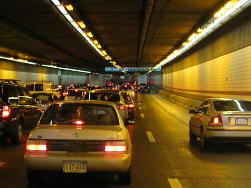
Today, the Charlesgate is known as a festering sore on the path between Kenmore and the Back Bay. The overpass is decrepit and falling apart. There have been some emergency repair efforts cluttering up the place from time to time. Below, traffic swarms on the wide avenues running beneath, and coming on and off the ramps at high speed. It is dank and shadowy, a combination of the overpass and the remnants of the trash-strewn Muddy River beneath. Residents complain that they do not feel safe at night walking there. They see bums and junkies hanging out. Although during the day there are enough people who venture there, at night it becomes an empty, secluded space. Even the cars aren't immune from this. While I was walking to the meeting, under the overpass, I saw someone with a can in his hand, walking up and down the ramp, pushing it into windows of the stopped cars, presumably begging for change.

At the meeting, several MassDOT representatives set up a presentation, led by Ned Codd. He introduced project Manager Paul Nelson who was the primary speaker and question fielder. State Rep Marty Walz was also in attendance to support her constituents. Paul began by saying that the project was to look at the possibility of adding some kind of ramp to the Mass Pike in the Back Bay. He also added that they would model the effect on the Bowker Overpass. He presented four alternatives for the ramp, though there was a lot of questioning distributed throughout the presentation. All that information should be posted on the website shortly. Most of the presentation focused on the results of a study done with a computer model of eastern Massachusetts traffic, extrapolated to the year 2035. The maps were dotted with level-of-service grades and projected traffic flow changes on the highways.
Example map with level-of-service grades. (courtesy: MassDOT)
By the end it was clear that not only were the computer models overly simplistic and unrealistic, they did not even bother to consider the effect any of their plans would have on walking in the area. It simply did not cross their mind. The reaction from the audience was a bit mixed, but vigorous. Representatives from Friends of the Charlesgate pushed hard for overpass removal. A few residents were concerned that surface traffic might be worse than having the overpass, although it doesn't seem any of them had considered the possibility that traffic levels could be reduced by changing Storrow Drive. Others had more immediate concerns about the proposed ramps and how that might effect them. Or how construction jack-hammering could keep them up all night, a problem that Marty Walz addressed in particular, because MassDOT had caused problems in the past.

Regarding the traffic levels, Paul Nelson actually made an interesting comment, though I'm not sure he has followed it through to its conclusion: "traffic may move [to other roads] but other traffic fills its location." He was referring to the model results for ramps on the Mass Pike, but it seems that it escaped him that his comment also applies to the way widening of roads brings along new traffic, the phenomenon known as "induced demand."

Fred Salvucci was also there and made some comments supporting the removal of the Bowker Overpass. He suggested that it should simply be shut down, and the effect measured in order to determine what the best course of action was to take after that. It is a waste to pump $11 million in repairs into a bridge like this. Much of the traffic on the Bowker now is headed to Longwood. He pointed out that the Worcester line is going to be upgraded shortly because the state purchased it from CSX, and it will have double-tracking through Brighton and the Back Bay, greatly increasing its capacity. He also pointed out that three-car trains on the Green Line will become more common and that will greatly ease crowding in the trains right now. Both of those offer alternatives for Fenway and Longwood commuters; especially with the new Yawkey station as Marc, the blogger of Transit On the Line, noted. Fred also pointed to Octavia Boulevard in San Francisco as a comparable overpass removal project.

Some of the comments from other residents: John S. noted that neither Bowker nor Storrow would be approved today. Don C. asked why there was no alternative without ramps. Sarah F. noted that the Charlesgate was "a really special place" but the overpass is a symbol that cars were the most important thing. Several asked why Storrow Drive was not being included in this analysis. A few years ago, there was a similar effort to start emergency repairs of Storrow Drive, because one of the grade separation tunnels was falling apart in an unrecoverable way, requiring $300 million in repairs. It has been shored up for the past few years but it will become an issue again soon. Unfortunately, the folks from MassDOT continually refused to consider Storrow Drive alternatives in combination with the Bowker Overpass. They insisted that it would be too big a problem.

(courtesy: Friends of the Charlesgate)
But therein lies the key to the whole issue: Storrow and Bowker traffic are inextricably linked. Each justifies the other. But with both of them falling apart, now is the time to reconsider their whole relationship with each other, the surrounding roads, and the surrounding neighborhood. It is time to put Storrow Drive at grade and recover the Esplanade Park for the use of people, instead of it being a hopeless median strip. At the same time, the Mass Pike extension exists now, and should draw off the load that Storrow has been carrying. There is no reason to spend upwards of $300 million in order to repair a road that is being used primarily as a cheapskate bypass of the tollbooths on I-90. And then once the traffic on Storrow goes down, a replacement surface road for Bowker will be much less busy, allowing us to reclaim Charlesgate Park as well. These issues must be solved together, and the refusal of MassDOT to do that seems to be a conscious decision to divide and conquer the community, in order to rebuild the highways exactly the same way they were built in the 50s and 60s. This attitude favors the suburban commuters, at terrible expense to the taxpayer, and to the detriment of the city residents.

I spoke with Project Manager Paul Nelson briefly after the meeting. He seems young, and a bit earnest. The issue I had in mind was that I have long been upset by the lack of a pedestrian walk phase on Charlesgate West at Comm Ave. Technically, there is no legal or safe way to cross that on-ramp to the Bowker Overpass. Thousands of people do it every day, since it is one of the only ways to get between Kenmore and the Back Bay. I often see people getting confused, or just dodging between cars to cross it. I asked Paul if, for the time being, he could take a look at fixing that situation in the short term. He was confused, and didn't know the place I was talking about. I said "you know, next to the comic shop." He then revealed that he "was new and unfamiliar with the area." Then he asked me "there is not even a [signal] head?" and I nodded, going on to say, "there's two phases: don't walk, and don't walk because there's a turn signal arrow directing cars across your path." He agreed to look into it.

That's where we're at. The MassDOT project manager is unfamiliar with the territory his work will affect. The rest of us are all too familiar with what it's like under there.

Related: On the McCarthy Overpass meeting in Somerville.

Is the MBTA actually being cost effective?

I spent some time last week perusing the National Transit Database. They collect fiscal and service information from transit agencies across the United States, and publish it in the form of spreadsheets and reports. For example, here is the profile for the MBTA in 2010. One of the things you can see is a breakdown by mode and the various types of expenses. I took the spreadsheet data and plotted a few charts to see how the T matches up against other agencies.


The above chart shows various commuter rail agencies laid out by the number of passenger car revenue hours they operate. The four colors represent the four different categories of operating expense: Vehicle Maintenance, General Administration, Non-Vehicle Maintenance, and Vehicle Operations. Since Vehicle Operations includes the cost of wages for drivers and operators, it comes as no surprise that its trend line is the steepest. It is also no shock that Long Island Railroad has the most revenue hours, followed closely by New Jersey Transit. But if you look back to where the MBTA comes in, the Operations cost per revenue hour is really low. Strangely low, actually. The Vehicle Maintenance cost is also low, the General Administration cost is very low, and the Non-Vehicle Maintenance costs are slightly higher than expected, though well within the reasonable range. So what's the deal? Has the contract with MBCR actually been a bargain? If we take a look at the same breakdown for Heavy Rail, which is provided in-house by the T, then we can see that it is pretty close to average there (NYC MTA is included but far, far off the chart):

What's different about the commuter rail is that, while overall it is far more inefficient than the subway, there are certain ways it can cut costs which are not acceptable for rapid transit: in particular, the limited or non-existent off-peak schedules. So is that really paying off, or is there something else going on? It's hard to know for sure, and there's some strange discrepancies in the data. For example, while the total annual trip count on the commuter rail is 36.9 million riders according to both the NTD and the 2010 Blue Book, there is a disagreement about how much was actually spent. The audited financial statement of 2010 claims that the commuter rail subsidy was $366 million, but the NTD only has $280 million reported. Even supposing that is due to some classification differences, the total operating expenses of the MBTA was $1.646 billion according to the audit, while the NTD shows only $1.179 billion. I don't currently have an answer for this. It could simply be a difference in the way these reports were generated. Perhaps, when using the "real" numbers, the MBTA's costs fall into line with the other agencies. Or maybe all the other agencies need similar adjustments in their numbers too, and the T still comes out ahead.

Monday, June 11, 2012

Obnoxiously wide roads


There should be a hall of shame for intersections like this one on Wallingford Road in Brighton. It's in a deeply residential neighborhood a few blocks away from Commonwealth Avenue. Presumably there are families and children living all around it. Can they really be happy about being forced to cross an Interstate Highway-scale road with cars whipping around the slight curve at high speed? My estimation is that this asphalt atrocity covers approximately 15,000 square feet (one-third of an acre). By comparison, my apartment building has a footprint of about 8,500 square feet (one-fifth of an acre). The curb shown in the distance is about 200 feet away from the camera. There are no curb cuts or crosswalks. As far as I can tell, the city doesn't want anyone to walk here.

Wednesday, June 6, 2012

Excellent news for Allston/Brighton commuter rail


State Reps Michael Moran, Kevin Honan, and Councilor Mark Ciommo stopped by a BRA community meeting today to announce that the New Brighton Landing commuter rail station will be going ahead with the support of New Balance. It will be at the Everett Street overpass and extend west. This adds a long desired urban infill station about halfway between the old locations of the Allston and Brighton B&A stations of yore. Arthur Street will be extended to the station to provide pedestrian access and a kiss-n-ride turnaround. This will come along with the agreement by CSX to move their Beacon Park yard operations to Worcester and clear the way for upgraded signals and double-track commuter rail operation on the Framingham/Worcester line.

Ever since what was briefly known as the "A" line trolley was discontinued in 1968, this part of Boston has lacked access to rapid or commuter transit rail, while having to contend with the extension of the Mass Pike splitting the neighborhood in half. The project will be part of New Balance's $500 million development project taking place in parcels abutting the commuter rail and Mass Pike. They are planning on rebuilding their corporate headquarters, adding a hotel, retail, and several office towers in addition to fixing the street grid and walkability of an area that has been light industrial for over a century.

Update: Related MassDOT blog entry.

Monday, June 4, 2012

Walk the line

A nice article about two people challenging themselves to walk the Red Line from Braintree to Alewife, visiting every station along the way. They finished in about 10 hours. Hey! They're making me look bad!

Sunday, June 3, 2012

Downs-Thomson and rapid transit in Boston

Revisiting last week's post about the Downs-Thomson Paradox in Boston, here's the charts for several rapid transit park-n-ride stations. Once again, the X-axis represents a time point in the peak morning hours, ranging from approximately 6am to 9am. The Y-axis is the number of minutes it takes to commute from the area of the named station to a spot in the Financial District; in blue by transit, and in red by driving. One big, immediately noticeable difference with the rapid transit charts is that there are many more blue dots: the reason being that the frequency of service ranges from 5-9 minutes consistently, instead of being sporadic and sparsely served like the commuter rail.