Pages

Wednesday, July 10, 2013

The BRA looks at reducing minimum requirements

Recently the Boston Restaurant Authority has indicated a desire to reduce their minimum soda requirements in new restaurants.

These requirements have been in place since the founding of the BRA in the 1950s, in order to assure that every patron has access to at least one free soda with every meal. In some cases, the BRA had been requiring two sodas per customer.

This measure had been intended to reduce demand for the depleting supplies of on-street soda machines.

Over the years, minimum soda requirements have been blamed for causing over-consumption of sugary drinks. The obesity epidemic, some say, is directly related to the excessive number of soda drinks being forced upon restaurant patrons, whether they order it or not.

"We don't need to push a soda with every meal," Peter Mead, head of the Boston Restaurant Authority, said in a recent interview. He cited US census data showing that one in three Boston residents is between 20 and 35, and most drink water, juice, or beer primarily.

Critics of the new policy claim that elimination of minimum soda requirements will cause a terrible soda shortage, as restaurants may choose to devote resources to other products, such as food. They say this will put a strain on already-short supplies in on-street soda machines.

A local woman complained, "If the BRA gets their way then families will leave Boston and move to the suburbs where they can get soda for free."

Another explained, "While I appreciate the idea of promoting public health, the city's public water transporter, MWRA, is not good enough to replace soda for everyday needs."

"The reality is that Americans love their soda and BRA officials are sticking their heads in the sand," said Charlie Sodalis, "it's policies like this that make me want to dissolve the BRA in a bucket of cola." But, when told that the BRA was the agency responsible for the minimum soda requirement in the first place, Charlie's head exploded in a fizz of cognitive dissonance.

An official said that the city will continue to explore relaxation of soda requirements in neighborhoods across the city, whether in Brighton, South Boston, or Jamaica Plain. This would not prevent people from purchasing and consuming soda in restaurants there, if they so choose, but instead would make it optional.

“We want to leave some room for negotiation in every community,” he said. “But if we don’t start to push people to pay for their own soda and consider other options, then that behavior is never going to change.”

Sunday, June 30, 2013

Tiny signs

Lately, these street signs have been popping up on and near Commonwealth Avenue:

"Caution: High Bicycle & Pedestrian Activity Zone. 25 M.P.H."

It seems that this is the follow-up to this announcement: Mayor Menino and Boston University Launch Bike-Safety Initiative.
In a continuing five-year effort to improve safety and calm traffic along its 1.5 mile-long main campus straddling Commonwealth Avenue, Boston University today announced with the City of Boston a series of measures to further protect cyclists and pedestrians, encourage bike use, and promote awareness of cyclists and pedestrians among motor-vehicle drivers. They will include new signage, enhanced bike-lane markings, and highway reflectors in the pavement.
Sounds good. I appreciate the consideration. But I have to wonder: does posting these tiny signs really accomplish anything? Personally, I barely notice them when I'm walking past. I can't imagine anyone in a car stopping to squint at a sign like this. Some are a bit more visible, some are not so much.

"Share the Road"

And there's still legacy screw-ups like this:


"Turning Vehicles - Yield to Bike"
The glowing green arrow is at driver's eye-level. The yield sign is up and off to the side. Which do you think will get noticed? Fortunately, this is not a high-volume turn.

Going back to the 25 M.P.H. sign in the first picture: is this setting the legal limit? Or is it just a suggestion? It is an orange sign instead of the MUTCD standard design. I know that Commonwealth Avenue is signed for 30 M.P.H. elsewhere, which is the standard speed limit for these sorts of roads in Massachusetts (*).

It's not really clear how these signs are supposed to help. Judging by the speeds at which motorists fly down Comm Ave, I don't think they're noticing the signs either, or caring. Signs don't substitute for good design. Instead of merely telling motorists that this is a busy pedestrian area, the layout of the street should show it.


(*) Write to your legislators in support of H. 3129 to change the default speed limit to 25 M.P.H. in urbanized areas.

Thursday, June 20, 2013

The replacement of the Cambridge Street overpass of I-90

MassDOT has decided to expedite project 606376 to replace the deck of an overpass of the Mass Pike that is located in Allston, along Cambridge Street. The plans are already in 100% design state because they have been sitting around for a few years. However, they are offering a chance to comment over the next ten days, and at Tuesday's public meeting, they pledged to incorporate suggestions if possible. This is probably a once-in-a-generation opportunity to help fix a blight that has plagued Allston since the construction of the Mass Pike extension in the mid-60s.
[The comment period for all this is now, ending by July 3rd. Please e-mail dot.feedback.highway@state.ma.us and reference the Cambridge Street overpass over I-90 project number 606376. You may also read more on http://cambridgestreetoverpass.blogspot.com/.]


View Larger map (final design bus stops shown as blue markers)

The project scope extends from the intersection with Harvard Avenue in the west, to the intersection with Lincoln Street in the east. It also includes several minor repairs to the pedestrian footbridge across the pike at Franklin Street, but nothing more significant. MassDOT has suddenly gotten interested in this plan after it languished for several years, because the deck is deteriorating to the point where replacement must happen within the next couple of years. Conditions above the deck have been nearly intolerable for the past few years as well.
The sidewalk is fenced off because it has gaping holes
Dangerous conditions

A little history: prior to the construction of the Mass Pike extension in the mid 1960s, Cambridge Street had a smaller overpass of the Boston and Albany railroad. Lincoln Street, Mansfield Street, and Royal Street all connected directly to Cambridge Street.


Cambridge Street in 1925

The construction of the highway meant widening the right-of-way. Homes along the south side of Lincoln Street were taken (including Fred Salvucci's grandmother's home), as well as some homes on Mansfield and Royal, and the streets were reconfigured. Lincoln Street was redirected to curve to the northeast, paralleling the new highway. The ends of Mansfield and Royal were chopped off and reconnected to Lincoln Street. Then, Lincoln Street was rerouted over the Empire Street right of way and re-attached to Cambridge Street where Mayflower Street is shown on the map above. The net effect was to sever the street grid and create an overly long, uninterrupted block from Linden Street to the new Lincoln Street intersection. Motorists treat this stretch as if it were part of the highway, racing at high speeds along the excessive capacity, and creating a scary environment for anyone not surrounded by 2 tons of steel.

Eagle-eyed readers will notice there is a "tunnel" marking by Franklin Street. This was the location of a 19th century grade-separated walkway under the tracks. This was covered over and replaced in the 1960s by the current Franklin Street pedestrian overpass, which connects a point opposite Highgate Street on the south side, with Franklin Street on the north side.

The Cambridge Street berm
There is also a ramp at Mansfield Street, to replace the street connection that once existed. It climbs the berm so that people walking from Mansfield Street can reach Cambridge Street directly.

The Cambridge Street overpass of I-90 was given six lanes of automobile travel, small sidewalks, and no safe means of crossing, over 45 years ago. It has remained so since, but the bridge deck has reached the end of its lifespan and must be replaced.

Both MassDOT and BTD have shown a willingness to improve conditions on the bridge for walking and bicycling. They have recognized that six travel lanes is massive overkill: the feeder streets only have one lane in each direction, so there is simply not enough connecting capacity to fill six lanes anyway. As a result, they have drawn up buffered bike lanes and wider sidewalks into the current plans.

Crossing Cambridge Street
Unfortunately, in the same plans, they have decided to place a quarter-mile long fence right down the middle of Cambridge Street, from end-to-end of the scope. The claim is that they are concerned about "safety":  many people trying to get between North and South Allston are unwilling to walk a half-mile out of their way to use one of the intersections. So, instead of providing safe places to cross the street, the state agency is simply try to block all crossing. But that's unacceptable to the community. We need north-south permeability here. The sheer number of people willing to walk down the center median and climb the current concrete barrier attests to that. Many of these people live in North Allston and need to access jobs, shopping or bus stops in South Allston. Others live in South Allston and want to reach neighborhood resources in North Allston. MassDOT needs to accept that north-south travel is just as valid as east-west travel on this city street.


Now, MassDOT wants to stick to their scope and their schedule because they feel hurried to get this done. I also agree that this project needs to get done as soon as possible. So this comment period will likely be the last chance to ask for improvements in the final design.

What's exciting about this project is that the city has apparently been making plans quietly for a kind of "corridor to the river" from Allston to the Charles that uses Cambridge Street. For many decades, this street has been a barrier to walking and biking, with dangerous highway ramps and speeding trucks, but it could be transformed into a gateway instead.


View Cambridge Street corridor to the river in a larger map

The River Street Bridge replacement project (shown in blue) will be underway right after the Anderson bridge is complete. So, after that, the missing piece is in the middle: Cambridge Street.
  • Cambridge Street is a city street, and should look and feel like a city street, not a "mini-highway."
  • MassDOT and BTD are both onboard, in principle, with fixing Cambridge Street and building this "corridor to the river" but they seem to be fragmented in planning. Management of the corridor is split between the two agencies. We need them to be on the same page so that the final outcome is coherent.
  • A quarter-mile long fence with no crossings is not acceptable to the Allston community. There needs to be a safe place to cross. Some possibilities include the Linden Street intersection, or the Mansfield Street stairs. It should be possible to put a coordinated traffic signal at Linden Street which helps crossing with no impact on motor traffic.
  • During construction, a 2 year period, portions of the bridge will be closed. There will be three phases: each third of the bridge will be shutdown and replaced, from north to south. Although I understand that there will be unavoidable impacts, MassDOT needs to ensure that non-motorized access is considered seriously during this time-frame.
  • The Franklin Street overpass attracts heavy foot and bicycle traffic, which must share a narrow sidewalk along the north side of Cambridge Street near Harvard Avenue. The MassDOT plans call for directing the bicycle lane up a ramp and onto that same sidewalk. It will be widened to 13 feet, but, it turns MassDOT engineers had not anticipated that there currently is (and will be) 2-way bicycle traffic on this segment because of the overpass. Luckily, there is a grassy strip adjacent to the sidewalk which could be taken for a sidewalk-widening easement. That needs to be considered.
Two bicycles take up all the space already; but look at that potential width!

The comment period for all this is now, ending by July 3rd. Please e-mail dot.feedback.highway@state.ma.us and reference the Cambridge Street overpass over I-90 project number 606376. Or you may write a letter to:
Thomas F. Broderick, P.E., Chief Engineer
MassDOT - Highway Division
Attn: Bridge Project Management
10 Park Plaza
Boston, MA 02116-3973
You may also read more, including the 100% design plans, on http://cambridgestreetoverpass.blogspot.com/.


Friday, May 31, 2013

Should we disband the Boston Redevelopment Authority?

Rachel Slade has a new article in Boston Magazine entitled "The Authority" in which she calls for the Boston Redevelopment Authority to be disbanded, and its functions of planning, zoning and development to be separated. The agency is an anachronism, a relic of the era of "urban renewal", and has too much power and too little accountability.

The West End wiped out (source)
I can't say I totally disagree with this assessment. All it takes is a trip downtown to remind oneself of the hubris and arrogance of the BRA. A stroll through Government Center does the trick. How could they be so stupid? What were they thinking? What we lost was irreplaceable. Scollay Square, the West End, Barry's Corner, large sections of Roxbury, Jamaica Plain, all wiped out for not conforming to the sterile vision of a few self-selected planners; or for being in the way of the new highway lifestyle that was to conquer all. To the planners of those days, the city was a merely a tool for the wealthy suburban residents. Anything that got in the way of that had to go.

However, that was a long time ago. We can't fix the past. The BRA of then is gone, and the BRA of recent years is different. The BRA of today holds community meetings. They do promote, or at least claim to promote, actual urban development instead of faux-suburbia. For example, the BRA nowadays requires commercial development to form a street wall, with little or no setback, and to put parking behind, out of sight. This is in contrast to several mid-century examples which were built as mini-strip malls in the middle of urban areas. The BRA of today is willing to approve projects with low or no parking requirements.
Transit-oriented vacant land, not so smart

Does that make the agency good or worth preserving? Not really. They have more than their fair share of failures; Slade lists many, and I would also add to that: the disgrace of having long term vacancy of so many transit-adjacent parcels in the city. Besides, the concentration of power in one Authority is too tempting and probably too dangerous. There might be some good people there now, but they may not always be there. It's telling that redevelopment authorities have been disbanded around the country. But, on the other hand, to do so is not always a success.

Slade's article cites San Francisco as a positive example of planning. But, it seems to me, that comparison casts the BRA in a very good light. San Francisco is a beautiful city but by urban development measures it's a sad failure. In 2011, SF added only 269 net units of housing (this past year has been better). This, despite being one of the most desirable locations in the entire country. Rents have sky-rocketed there, much more so than here. San Francisco is infamous for possessing some of the most vocally anti-growth residents on the planet. And Boston is full of its fair share of such folks too, who oppose change no matter what, or who have ulterior motives.

On the one hand, you can hardly blame them: people still remember the bad old days of the 60s and 70s. The popular movements which arose and stopped the highway devastation from progressing further were heroic. And there continues to be community members who make thoughtful comments, provide positive feedback, and help bring about broadly beneficial outcomes. That's how planning ought to work. But the same mechanisms are also used by selfish individuals to do things like effectively grant themselves free parking privileges on publicly-owned land. Others fight against badly needed housing development because of some unsubstantiated fear of buildings. Bus lanes are blocked because someone yells "Gridlock!" I even heard one woman complain of not having enough open space for a development that happens to be next to one of the largest parks in Boston.

It's absurd. And who's going to stand up to that? Who will separate the sensible concerns from the ridiculous demands? That's what I want to know. Let's disband the BRA and replace it with a separate city planning department, a zoning department, and a development office. But let's also put in place a mechanism to prevent the various neighborhood NIMBY groups from dividing and conquering the new offices. We can't have a system where politically savvy groups get to squelch growth. All neighborhoods have to participate. Nobody is special. We could start with the idea of a Zoning Budget: "All deviations downward from planned growth in housing supply expressed in the [zoning] budget should have to be offset by corresponding increases elsewhere in buildable as-of-right land." Or a city department which promotes economic growth as a counterbalance to the stasis status quo. Or zoning which sets broad goals but does not micromanage how to get them.

Another thing: a city planning office sounds nice in theory. But I have reservations about it. For one thing, "planning" in this city (and this country) has a long record of failure. "Urban renewal" in the 50s and 60s was part of that. Zoning is another part. When you examine that zoning plans that were derived from community input, you will find that the limitations are laughably low. Much of Boston that we know could not be built under today's zoning code. That's a travesty, a complete failure of planning. How can you claim to "plan for the future" when your plans don't even accommodate for today?

The problem is that when most people think about zoning they think "oh, it keeps the polluting factory separate from the school." And that's where they stop. And since protection from pollution is a good thing, people have a generally good feeling about zoning, they don't question it. Unfortunately, zoning was taken much much further over the past 60 or so years that it has been in effect. It's been a way for bureaucrats and snobs to dictate details of buildings down to the inch. Your front yard is only 19 feet? Too bad! People who can't afford a single family detached home are treated like they were toxic waste and are told to live in a "multifamily district." You want to open a dentist office where a barber worked before? Incompatible! As-of-right development is curtailed all the way down to almost nothing, and some NIMBYs still think that's too much. We've come a long way from a country where buying your own land meant you had the freedom to build what you desired on it -- even if your choices are entirely safe.
Destroying buildings to widen Cambridge Street c.1920 (source)

The failure of planning dates back even further, before the Great Depression. A planning craze, that bubbled up from the late nineteenth century, swept the nation about a hundred years ago (see also this for a laugh) and a planning board was set up in Boston, like other cities. Reading through their old journals is interesting and yet hair-pullingly frustrating. It seems that every other proposal they came up with was to do street widening. The mass-produced automobile was not even a decade old, most people didn't have one, but these planners couldn't wait to start bulldozing blocks and widening streets. A lot of it may have been rooted in racial politics of the early 20th century; the elites wanting to sweep out the undesirables. Some of it may have come from genuine concern for the conditions (after all, we've come a long way in sanitation) with little understanding of the dangers posed by motor vehicles, nor any comprehension of the value of the small streets to city life.

The point is that the central planners of those days didn't understand what they were dealing with and didn't know what the future would bring either. Olmsted was, at least, honest about this:
Speaking at the second national conference on city planning at Rochester, NY, in May, 1910, Olmsted, for one was almost overwhelmed by "the complex unity, the appalling breadth and ramification, of real city planning." He realized, not for the first time, that he and his fellow practitioners were "dealing ... with the play of enormously complex forces which no one clearly understands and few pretend to." He humbly acknowledged that "our efforts to control [these forces] so often lead to unexpected or deplorable results that sober-minded people are often tempted to give up trying to exercise a larger control [...]"
Why do we think we're any different? Maybe we absolutely cannot get by without city planning, but that doesn't mean a city planning department is going to get it right. How can they? A city is a complex system, not necessarily amenable to central planning. You can point to the Back Bay as an example of a planned area that worked out pretty well. But that was completed before the heyday of "city planning." And we haven't been able to replicate that kind of success in modern times, ever since planning became an established profession. We can't even figure out how to build anything decent anymore. Whether it's due to architects more intent on stroking their own egos than building nice places, or NIMBYs clamoring for more free parking, or just a quality that we cannot seem to grasp, we just don't seem to know how to make successful urban districts. Instead, we take existing ones, pump money into them, and pray.

So, disband the Boston Redevelopment Authority. But don't expect separated planning, zoning and development departments to lead to nirvana. Planning is just a tool; it can easily be used to create boring, sterile districts, and often has. Most of suburban sprawl was planned to be that way, and then laced into a zoning straitjacket to prevent any spark of life from ever arising. Without making some fundamental changes to the way planning is done -- such as the Zoning Budget -- you're just shuffling offices around and creating more bureaucracy, but not making any positive changes.

Saturday, May 25, 2013

Minimum parking requirements in Boston

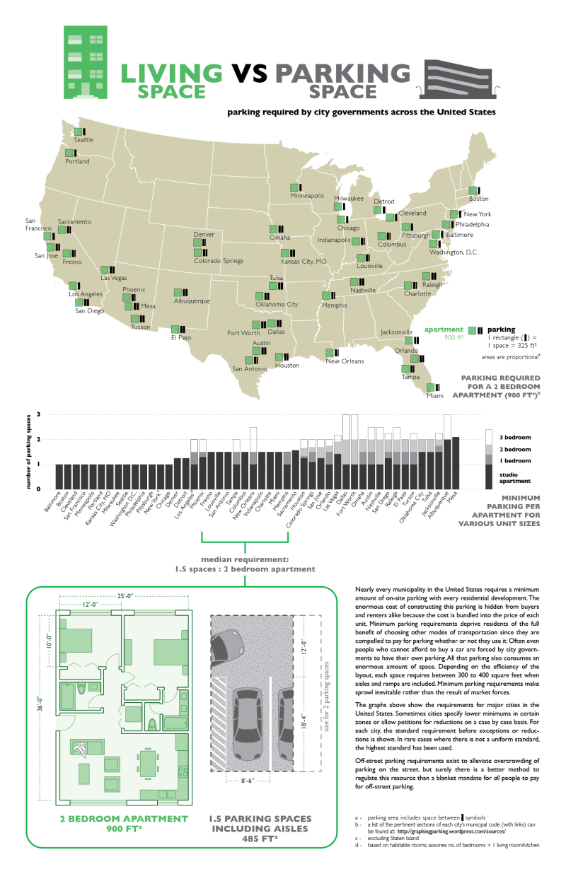
A relatively new web blog, "graphing parking", has popped up recently which aims to visually document the incredible waste and burden caused by minimum parking requirements/subsidies around the USA. I encourage everyone to check it out. Here's a sample:
Living space vs parking space (graphing parking)
Not to detract anything from Seth's effort, but I think he's going too easy on Boston here, listing it as 1:1 is not quite the right story. Although there is technically a master table of parking requirements that I've mentioned before, based on FAR, our zoning code is split up into a whole bunch of districts and each of them has their own particular tables and exceptions. I do understand that it's impossible to represent that sanely in a visualization. Instead, here's a table which summarizes a bit more comprehensively the current reigning minimum parking requirements in Boston:

Off-street minimum parking requirements for various neighborhood districts
A few notes: these requirements only apply to as-of-right development which is not subject to Large Project Review. They can also be superseded by Planned Development Areas. Each neighborhood zoning code seems to have its own way of wording things, so I've simplified a bit. These requirements only apply to normal or "other" residential development (not elder housing, etc). Some codes categorize by "1-3 units", others by "1-4 units" and others not at all. So I've settled on "1 unit", "5 units" or "10+ units" as intermediate samples.

As you can see, much of Boston suffers from higher minimum parking requirements, particularly on multi-unit buildings. I find it quixotic that larger multi-unit buildings have to comply with even more onerous parking requirements, when typically such buildings would be found in densely populated areas close to transit. I suspect that this forces most larger buildings into Large Project Review in the process of receiving variances. It's also the case that the zoning code does not distinguish between a studio and a 3-BR apartment when it comes to parking requirements. How many people living in a studio really need 2 parking spaces? Probably a very small percentage, if any.

It's pretty appalling that the North End is subject to any minimum parking requirement at all, considering that at least two-thirds of the residents do not have a car. By contrast, the South End and Bay Village have at least reduced that to 0.7 and do not require any parking for small projects.

The way Allston is lumped together with Brighton with very high minimum parking requirements is another example of bad zoning. In fact, the neighborhood boundaries don't make sensible planning areas here at all, due to geography. The sections of Allston/Brighton within a few blocks of Comm Ave -- from Packard's Corner to Cleveland Circle -- are almost all densely populated, with low car-ownership, and high transit use. Requiring 2.0 parking spaces per unit there is simply insane, and out of character with the existing built environment. I happen to know that the people who worked on this particular neighborhood code largely live in the suburban outer reaches of Brighton, and it was wrong to impose their schemes on Allston and Comm Ave.

Roxbury, South Boston and Mattapan only require 1.0 per unit even though they are less densely populated than Allston. Roxbury has a lower car-ownership rate than average, Mattapan is about average, and South Boston is higher than average. I don't know how they arrived at these decisions. But it all seems pretty arbitrary, which is a terrible rationale for a regulation that increases housing costs and decays neighborhoods.

The BRA should really revisit all of these codes and revise downward or outright eliminate any minimum parking requirements. Most of them are 20 years old. A lot has changed in the way people think since the early 90s. The minimum parking requirement is a measure intended to subsidize parking in the city, to force everyone to pay for an amenity that only some may use. Nowadays we recognize that adding parking creates traffic, that it reduces opportunity, raises housing costs, and deadens neighborhoods. There's no good reason to subsidize it; the market is perfectly capable of supplying parking to meet demand, and it should be treated as just another land use. Even places where car-ownership is high do not need minimum parking requirements: why would developers build something that they couldn't sell? Nobody expects to be given a free 200 square feet of floor space for any other use, and I don't see why parking should be the exception to that. 

Saturday, May 4, 2013

Sign of spring


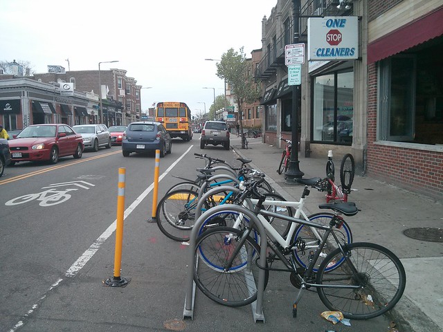
The bike racks are back, and busy as ever, helping keep the sidewalk clear of piled up bikes. Perhaps they are also a sign of thawed relations with BTD, which has started acknowledging the existence of non-motorists finally, this past year. They are also supposed to install a pilot "parklet" on Harvard Ave soon, near the @Union Cafe, and paint "bike priority shared lane markings" on Brighton Ave to try and address some of the safety issues along that corridor.

Friday, April 26, 2013

A better idea for Melnea Cass Boulevard

Chicago is proposing a conversion of a portion of one of its busiest bus routes to BRT. The street is 70' wide curb-to-curb and currently has 4 travel lanes, 2 parking lanes, and a median/turning lane in the center. The bus lanes will be created by taking 2 travel lanes and the center median; left turns will be prohibited. There will be off-board ticketing and signal priority to keep buses moving along.

Ashland Avenue proposal (source)
Compare that to the proposed Melnea Cass Boulevard bus lanes:

Melnea Cass Boulevard proposal (source: 3-6-13 presentation)
It's not entirely comparable -- CTA plans to use buses with doors on both sides -- but the Chicago proposal looks much more neighborhood friendly, and the street much safer to be around.

Melnea Cass Boulevard is much wider than Ashland Avenue, but the sidewalks are much smaller in the Boston proposal. The buses here will have to contend with left-turning traffic, unlike Ashland Avenue. And finally, the Melnea Cass proposal is for a very short segment of the handful of bus routes that use it, whereas the Chicago proposal starts with a ~6 mile segment and will eventually extend to a full 16 mile route. Here, if the Urban Ring were ever to be built using BRT, then the initial tiny segment would become something more significant. But widening would hurt the community along the Melnea Cass corridor permanently, even if it were to get transit service befitting an urban location. This Chicago proposal is a better model for a busy urban corridor in a well-developed American city.

Sunday, April 14, 2013

The Senate transportation bill

The version of the transportation financing bill passed yesterday by the State Senate is an improvement on the House version. The key features are an immediate increase in the gasoline excise tax by 3 cents, the annual indexing of the tax to inflation (by CPI), an increase in cigarette taxes, an investigation into the sale of naming rights to stations, a commitment to obtain revenue from utility easements on public rights-of-way, and a cap on fare hikes of no more than 5% every 2 years. There are also some other interesting aspects that have not been discussed as widely.

  • A "value capture commission" to study the best practices of other jurisdictions regarding how to obtain benefits from public investment in transportation, then to submit a report with recommendations. This was also present in the House version, although I missed it before writing my critique a few days ago. The usefulness of this provision will depend on how well it is implemented; it seems pretty weak, though, and I don't think it really addresses my concern about land use. But it is something.
  • Explicit identification of the Green Line Extension and South Coast Rail as priorities.
  • The creation of a report discovering and describing fare evasion statistics, as well as methods to address the problem.
  • Language allowing for a "high occupancy toll lane" facility to be developed.
  • A study of taxicab markets and needs in the Commonwealth.
  • A premium parking pilot program in select MBTA parking garages; this allows users to pay a higher fee for a guaranteed, convenient parking space.
  • Calls for the MBTA to issue a request for proposals from business, civic, and non-profit entities to enter into sponsorship agreements for providing late night transportation services.
  • Allows for tolling facilities to be constructed on the various highways as they cross over into Massachusetts from neighboring states.
  • The Underground Storage tank fee would also be indexed to inflation annually (by CPI).
We will have to wait and see what the conference committee comes up with and whether that is acceptable to Governor Patrick.

Wednesday, April 10, 2013

This week in transportation funding

This week is big for transportation funding in the Commonwealth. The state senate and the state house will be discussing the legislature's proposal for funding that was offered in opposition to the Governor's plan, "The Way Forward." Presumably they will be coming up with a plan going forward to close the operating deficits of both the highway and transit divisions of MassDOT, as well as finding funds for some capital improvement projects; although the details of those projects may be determined later.

Plenty has already been written about the competing plans, and there's even a Walk/Bike Summit at the State House tomorrow. Obviously, I support fixes to the broken state of MBTA funding, and improvements to walking, bicycling and transit state-wide. So I'm largely in favor of the Governor's plan, although with the notable exception of South Coast Rail. Also, I have a problem with the way Chapter 90 road funds are handed out, because it favors rural parts of the state disproportionately. And I do like the legislative plan to index the gas tax to inflation.

I just wanted to bring up the fact that throughout this discussion, there's been pretty much no attention paid towards land use planning in conjunction with transportation planning. There's been separate initiatives, like Menino's Housing Boston 2020, but for some reason there's a disconnect between that and transit planning. This is not to say that there aren't people out there thinking about them in conjunction; there are, such as MAPC and MA-SmartGrowth. But the connection doesn't seem to have made the leap to the legislature.

I'll give an example: the Green Line extension is a legally-mandated Big Dig mitigation project. The current proposal before the legislature endangers the Federal funding support, which would double the cost that the Commonwealth has to bear. This is exceptionally short-sighted. But it's even more short-sighted when you realize that the Green Line extension, in combination with McGrath Highway grounding, will completely revitalize and regenerate a whole section of Somerville that is currently in bad shape. That's a whole lot of benefits -- housing, business, quality of life, revenue -- which are simply not being considered by the legislature when making tunnel-vision decisions about transportation alone.

Now it's true that legislators probably do have some of this in their head while working on the bill. At least, I hope so. And Somerville has their SomerVision plan which lays out their intentions. But it should be part of the bill. We the taxpayers, the citizens of the Commonwealth, are going to invest in transportation improvements for certain areas (not just Somerville, of course). In return, we want something for that investment. We want more housing units, more jobs, more opportunities, in some combination and form, all of which leverages this transportation investment we are making.

I say this because we've seen large transportation projects completed in the past which did not see complementary development, and thus wasted their potential.

Across the street from Roxbury Crossing MBTA station
The Southwest Corridor is one of the most egregious examples. A large swathe of Roxbury was destroyed to clear a path for the never-built Inner Belt and Southwest Expressways. And then, instead, the Orange Line was relocated to that path. But then, for the past few decades, so much of the land has remained vacant and empty.

There's also the long stretches of Commonwealth Avenue which are devoted to low intensity uses like automobile body shops and parking lots, despite being Green Line adjacent. Or the empty vistas immediately adjacent to Maverick Square station, apparently owned by MassPort but lying fallow. Or the billions of dollars spent on Commuter Rail expansion which ultimately ended up being a glorified parking lot shuttle. The Big Dig remains a large question mark; will we ultimately see development along the former corridor, or will it remain the world's most expensive median strip?

So I hope that funding levels will be higher than the current legislative proposal. But I also hope that when it comes time to evaluate the different projects, that the disbursement of the funds will be contingent on local land use and zoning reforms which will make it worthwhile.

Monday, April 1, 2013

The MBTA expands westward

The MBTA's fresh new logo
Feeling a little let down by Spring? Dreary of being drenched by April showers? Perhaps you're tired of high housing prices for small apartments, traffic congestion wherever you go, and fighting for a parking space when you get there? Are you just itching for a little sun and some desert fun? Or is West Roxbury just not "West" enough for you? Whatever the reason, the MBTA has just expanded its service to a whole new area.


It's a veritable NIMBY paradise:

  • No buildings taller than 2 stories, so you won't feel "menaced" while walking near them.
  • Plenty of setback from the road.
  • Shadows are basically non-existent.
  • Lots of "greenspace" in the form of palm trees, cacti and scrub bushes.
  • Ample free parking. Always.
  • Approximately zero congestion. All intersections operate at level of service "A" or "B".
  • You may not ever see your neighbors; much less hear them.
  • Beautiful mountain scenery.
So what are you waiting for? Just hop on the Route 1 bus.