Pages

Showing posts with label parking. Show all posts

Sunday, July 26, 2015

Affordable housing money wasted on pointless parking spaces

Just a quick blog post on something I noticed yesterday. A quote from a letter filed with the BRA regarding a new project on Telford Street:
At the recently constructed Charlesview project across Western Avenue from the Telford Street project site, the fully occupied 240 unit residential development has about 180 spaces of its 248 space parking garage used. Since there is no additional fee for parking above monthly leases at Charlesview, these numbers represent a true parking demand of about 0.74 spaces per unit.
Think about how much affordable housing money has been wasted on these luxurious accommodations for automobiles -- which aren't even being utilized.

Sickening.

Saturday, December 13, 2014

The SPOT app undermines the Clean Air Act, and therefore our air quality, in Boston

I recently read about the "SPOT app" that allows people to easily rent out an empty parking spot that they own and are not using. Sounds reasonable enough. I'm a fan of making more efficient use of physical resources. It's the opposite of "minimum parking quotas" that force everyone to waste huge amounts of land and money, and yet still fail to meet parking demands.

"SPOT app" (source: BostInno)

But, when I took a look at the map included with the article, it occurred to me that there is something not quite right about this. The app allows you to rent spaces in the Back Bay and downtown Boston. It transforms so-called "accessory spaces" that are attached to particular uses (such as residences) and allows them to be used instead as "commercial spaces" that are available to anyone, for a price.

So what's the big deal?

Well, back in the 1970s, the city of Boston was facing an air pollution problem caused by the creation of all those urban highways that tore through the city, bringing hundreds of thousands of cars spewing exhaust fumes into the air. In order to satisfy provisions of the Clean Air Act, the city of Boston agreed to cap the number of "commercial spaces" that would be available at any one time. It's called the "parking freeze" and it's intended to help preserve our air quality. The downtown Boston parking freeze cap is currently set at 35,556 spaces, and there is no capacity for new spaces at the moment. Yet, the SPOT app is effectively creating new commercial spaces that have not been subject to the parking freeze regulations. That means more cars, more air pollution, and more congestion.

I think it would be appropriate if the company that created the SPOT app were to be proactive about dealing with this air pollution problem. Perhaps they should disable the use of the app within the parking freeze zone until they figure out a way to mitigate the air pollution caused by the additional cars they may be attracting into downtown Boston. Perhaps it should only be available for electric vehicles within that zone. Or perhaps they need an allocation from the freeze "bank" in order to offer spaces in that zone. I don't know what the best solution is. But I do know that it is something that should be addressed. 

I'm also a little disappointed that City Councilor Frank Baker did not consider the implications for the parking freeze, the Clean Air Act, and our air quality, before providing an endorsement of the app.

One thing I did find really interesting is that the company behind this app has been collecting price information about short-term parking in various parts of Boston. This article has a breakdown. Average prices range from $1.75/hour in Allston/Brighton up to $3.75/hour in Back Bay. What's remarkable about these averages is that (a) they're higher than the city-wide set meter price of $1.25/hour, and (b) they're really not that expensive, and quite reasonable when compared with typical meter prices in other American cities. Even the Back Bay's average market-driven price of $3.75/hour is less than meter prices in busy parts of Vancouver, New York, Chicago, Los Angeles, and Seattle. Does it really make sense for places like the Back Bay and the South End to have city meter rates that are comparable to Boulder, CO or Rochester, NY (both $1.25/hour)? Hopefully, this inspires the city to give another look at using smart parking reform to address parking issues, instead of hurting the residents of the city with onerous minimum parking quotas. Those quotas are especially harsh on people who don't even own automobiles and yet are still forced to pay the cost to park other people's cars.

Monday, December 1, 2014

Thoughts on Question 1 and transportation funding in general

It's been a few weeks since the November elections, so I'm chiming in a bit late, but there's no real hurry. There weren't really any surprises with the state-wide office elections, and I don't know how that will all shake out in the new year when the new officials take office. But the success of Question 1 was a bit of a surprise to me. Part of that is the almost complete unreliability of polling on such questions. But also because Question 1 was so obviously a "Tea Party temper tantrum" that I figured Massachusetts voters would see through it.

In the past year, the legislature had finally taken some responsibility for transportation funding -- after twenty years of denial. They raised the gasoline excise tax by 3 cents, not enough to make up for the value lost through inflation, but something. And more importantly, they arranged an "indexing mechanism" that would ensure that we would not suffer through another twenty year period of fiscal farce. The "indexing mechanism" would keep the value of the excise tax steady over the years, ensuring that the regular effect of inflation would not become a source of de facto tax cuts.

Question 1 repealed the "indexing mechanism", thereby spurning the fiscally responsible step taken by the state legislature. Therefore, the gasoline tax will, in effect, receive an automatic tax cut every year going forward, again. Voters here have rejected irresponsible tax cuts in the past, so it's a bit of a head-scratcher, but hopefully not a trend-setter. In any case, if you are ever in conversation with a voter who claims to be "fiscally responsible" ask them if they voted for Question 1: if so, you can safely call them a hypocrite.

So what happens now? Well, the legislature is going to have to scramble a bit to find funding for some things. There are still plenty of failing bridges, potholes aren't going away, the T has 45-year-old subway cars that can't go without replacement, and buses have to be replaced on a regular schedule. It appears that the latter two are not in danger, and neither is the important Green Line Extension project through Somerville. But funding for everything else is questionable. That includes part of the cost of the Allston Interchange project that will replace the failing riverfront viaduct of the Mass Pike and reshape the area, fixing many of the problems that the existing highway afflicts on the neighborhood. There's the River Street and Western Ave bridges, which are crumbling. And several hundred other overpass and bridge repair or replacement projects that I could scarcely begin to enumerate. Roads ain't free, despite the feverishly held beliefs of the mostly suburban, mostly automobile-dependent voters who forced Question 1 on us.

Meanwhile, MBTA bus and train fares are virtually guaranteed to go up by about 5% every two years. Somehow, once again, public transit riders have been left holding the short straw, while drivers continue to reap steadily increasing subsidies in the form of inflation-driven gas tax cuts. Funny how that always seems to happen.

Paul McMorrow has suggested that we should adopt the idea of regionally-based taxes to pay for transportation projects. Ballot questions enacting regional sales or payroll taxes are popular in many western states. But it's not constitutional in Massachusetts, so this would require some fancy footwork or a change. And there's a bigger problem: we will end up with a system where transit projects are funded via additional regional taxes, while highway builders get to keep helping themselves from the general fund. Not a good dynamic. If Boston is forced to tax itself just to keep the MBTA running, then why should Boston subsidize highways in central and western Massachusetts? Either all transportation projects should be considered regionally, or none at all -- because we're all in this together.

For a few ideas to consider, check out the report last month from the Urban Institute about how the various states are handling the gas tax. Some have indexed the price in various ways to the going wholesale price of gasoline, which is one way to simulate a percentage-based tax like sales taxes. Oregon and Virginia are piloting a major reform that replaces gas taxes with vehicle-miles-traveled taxes. This is thought to better represent the cost to society of operating a vehicle on the public ways. The Federal government has also floated the idea of allowing tolling to be used on interstate highways (where it was not grandfathered). Tolling would be a fair way to obtain funding for highways, the counterpart of paying a fare to ride a train or bus. Used properly, it would also have the benefit of actually reducing congestion: with automated electronic tolling it's hassle-free, and part of the proceeds can be used to fund really good public transportation for people who don't or can't drive.

Here's a reform package I've been thinking about:

  • Apply sales tax to gasoline. Right now, gas is exempt from the sales tax, which is a hugely regressive subsidy to drivers at the expense of lower-income families. If we were to instead apply the sales tax to gasoline, then the overall rate could be lowered, so that other goods and products that everyone buys would not be subsidizing gasoline (at least, not as much). This could be designed in such a way that any increase in cost for gasoline would be made up for by decreased cost in everything else.
  • Change the purpose of the gasoline excise tax: instead of funding transportation, an excise tax on gasoline should fund clean-up of the pollution caused by gasoline usage, and also public health efforts to mitigate the damage to human health caused by gasoline usage. The rate of the gas tax would be set at the level needed to achieve these public health goals, which include the Healthy Transportation Directive and the Mode Shift Goal.
  • Other excise taxes should go into the general fund.
  • Transportation should be funded out of the general fund based on the merits and cost-effectiveness of each project in question. Such projects should have to compete with other worthy projects in other departments, such as schools, housing assistance, health care, and yes, even tax cuts.
  • Ridiculously bad boondoggles such as South Coast Rail, which is expected to cost the state over $500,000 per projected rider, should be discarded until somebody finds a way to get the costs under control.
  • All congested highways should be outfitted with variable, automated, electronic tolling. The tolls would vary from free (when there is little demand) up to whatever amount is required to clear out congestion at that time of day. The precise formula would have to be carefully designed in order to avoid surprising people. The revenue from the tolls can be used in several ways, and there is a reasonable argument that some of it should be used to ease the regressive effect of the tolls. Part can go to boosting public transportation capacity and frequency along the corridor, making it a real, serious option for many more people. This has the nice side effect of bringing the benefit of the transportation infrastructure to the many people who cannot drive, for whatever reason. Another part can go towards income tax relief for the low-income users of the highway who still need to drive. The rest should go into the general fund.
  • End all parking subsidies. That includes the minimum parking quotas found poisoning most zoning codes. The authority to impose such quotas, which are an intrusion on private property rights, comes from enabling legislation in the General laws, so it should be possible to retract that authority at the state level. Minimum parking quotas waste land, destroy healthy environments, raise housing prices, and, in general, these kinds of subsidies help cause traffic congestion. It's hard to imagine a more self-destructive set of regulations.
Does this package have a chance of ever passing? I doubt it. There's too much powerful, vested interest in the status quo. As we saw with Question 1, people don't like it when you end their subsidies, even if they are really harmful, self-destructive subsidies that cost the rest of us dearly.

I'd be interested to hear other people's ideas about transportation funding reform.

Tuesday, December 10, 2013

Thought experiment: how much bus service can you get for the price of a parking garage?

Looking through some old data, I noticed that there's a common theme: the marginal operating cost per weekday of your typical frequent MBTA bus route is about $20,000. For example, the 1 bus is $18,456 while the 39 is $22,206. The 57 comes in at about $19,544. All of them are estimated to recover approximately half of that in fares, so overall marginal subsidy per day is about $8,000 to $12,000.

Mind you, the marginal operating cost only factors in the cost of running a bus per hour, plus the cost of driving it per mile. Maintenance, depreciation, administration and other facilities are not covered. But if they had the equipment lying around, then it might be fair to say that adding a weekday's worth of 57-like bus service costs approximately $10,000.

We know that excavating an underground parking garage can cost from $50,000 to $100,000 per parking space (sometimes more, sometimes less, depending on conditions). Speaking loosely, then, each underground parking space could cover the net cost of approximately 5-10 weekdays worth of key bus route service. Let's just assume for simplicity that every day has the same cost as a weekday. Then a year's worth of key bus route service could be covered for the same cost as 36 to 73 underground parking spaces.

A year's worth of bus service. (photo source)
Does this come up in real life? I think it's fair to expect several hundred parking spaces to be built along every core bus line every year. I can think of several hundred that came online along Comm Ave just last year, including some built at a deep (expensive) level. And another few hundred planned for Washington Street in Brighton. The Fenway is seeing plenty of garage construction despite the parking maximums in the neighborhood. Then a quick browse of the BRA's website shows 216 spaces (aboveground) for Kenmore Square, 236 spaces (3 floors below ground) on Harrison Ave in the South End, and 63 underground spaces on E Street in South Boston, just to pick a few examples.

I have been talking marginal costs up until now, but spaces are typically not added one-by-one. Instead, it's whole levels at a time. For example, a developer might propose 80 dwelling units and 60 parking spaces in an underground level. Some misguided neighbors might demand more parking spaces be added. But the only way to do that would be to go yet another level underground. Perhaps the developer can add another 40 parking spaces by doing that. The garage now costs about $5 to $10 million to excavate. Those costs are passed onto to the eventual tenants, and create more traffic and pollution in the area.

Alternatively, the developer could propose to pay for a year's worth of frequent bus service. The cost of adding that additional underground level could easily cover the marginal yearly cost of running a key bus route. Furthermore, doing so would help everyone in the neighborhood rather than a handful of car-owning tenants, would ease traffic and pollution instead of increase it, and would contribute to a better urban environment. And there's likely more than one such eligible development project per year.

I have heard people propose the option of replacing parking subsidies with transit subsidies. It's also a similar idea to value capture. It seems like it may be feasible after all. Some might say that it's unfair to put the burden of providing the public service on a private project (the usual objection to value capture) but I believe it is also unfair for the government to force people to subsidize parking spaces. If you're going to have parking quotas, which are ultimately harmful to the public, then it behooves you to allow them to be replaced by transit support payments, which are beneficial to the public.

Saturday, November 23, 2013

Bad parking policy, in one picture


On one side of the street, BTD has installed parking meters at the "usual rate" of $1.25/hour. On the other side of the street, the curb is left largely unregulated except for street cleaning. It shouldn't be too hard to figure out which side is which.

What you are seeing here is a case of poorly designed parking policy. The metered spaces have a price that is too high, and are therefore going wasted. The unmetered spaces have a price that is too low, and are therefore overcrowded. The correct price is somewhere in between, where "correct" means: achieves a reasonable level of utilization that still leaves a few spaces open for new arrivals. Prof. Donald Shoup's rule of thumb is that prices should be set to achieve approximately 85% utilization, which ensures that there will be at least 1-2 parking spaces available on every block, at almost all times.

BTD's bad parking policy and refusal to consider reform means that people continue to suffer unnecessary headaches, and they make claims of parking "shortages" even while most of our neighborhood is covered in asphalt. Although I don't own a car, I still find it important to fix. For one thing, it's the right thing to do. For another, bad policy in one area tends to infect other areas. Much of our land use policy, for instance, is dictated by the supposed "shortage" of parking. Even though about half the residents of this neighborhood don't have access to a car, they are forced by zoning rules to subsidize other people's parking. Those regulations came about because the on-street commons is managed improperly, creating an overcrowding problem. And then, instead of solving that problem the correct way, politics dictated bad ideas like "minimum parking quotas" which dump the burden onto the people who are least able to afford it, and also least able to oppose it.

This goes beyond just rent, and home prices. Economic development in this neighborhood is artificially depressed because of regressive policies like minimum parking quotas. The suburban-style space requirements of that many automobiles are too much for a compact city neighborhood. The net effect of this heavy-handed government regulation, to force more cars on us, is to squelch normal, healthy, incremental growth. Instead, we get almost nothing, and hardly any changes, for decades. That's a lot of lost jobs, lost opportunity, a heavy price to pay, all because of an irrational fear of parking "shortages" caused by broken policies that do not make sense in urban areas.

Tuesday, October 1, 2013

Car-free housing in Boston is natural

(Also check out Paul McMorrow's rebuttal: Boston could be car-free, it's how people actually live.)

There are so many flaws in Tom Keane's most recent column for the Globe, that it is almost too easy to pick it apart. Take the first sentence:
CAR-FREE condos and apartments, the latest fad in residential living, are really little more than a gimmick: good for greens and developers, perhaps, but bad for residents.
The "latest fad?" I suppose that Tom believes that 19th century apartments were built with parking spaces? A little bit of history tells us that minimum parking requirements began with the 1950s zoning codes, a fad of its time, and the result was decades of disaster and urban decay. Then there's a little shot at people who live without a car: according to Tom, they must be either those wacky, crunchy "greens" or some market cooked up by sneaky, greedy developers. According to Tom's reasoning, these dastardly developers are just itching to dump millions of dollars creating a product that nobody will buy.
Thus, real estate developer Related Beal LLC is now proposing to create 175 units near TD Garden without adding in any new spots. 
There’s a certain sleight of hand to the idea, since residents wouldn’t have to abandon their cars. As Related Beal acknowledges, it’s hoping to piggyback off of existing nearby parking. So this isn’t actually a car-free building as much as it is one that dumps the problem on someone else.
I feel strange explaining the concept of a market to someone as old as Tom Keane. The idea that residents could rent or purchase a parking space in a nearby garage should not be that difficult to grasp, and it's not much different from the many other transactions which take place between residents and local businesses. For example, most apartment buildings are not constructed with grocery store requirements. However, most people seem to understand that when a resident wants a bottle of milk, they can walk down to a nearby store and buy one. We do not need to build "minimum grocery store requirements" into the zoning code because those products are handled perfectly well by normally operating markets. And parking spaces are no different. They are just one type of land use, among many, that can be purchased or leased on the real estate market.
But suppose new buildings truly were car-free, with residents somehow compelled to give up their cars? A few might be persuaded to do so, but in the long run such a proposition would run headlong into one big problem: Even in Boston, people need cars. Manhattan, a uniquely dense and compact island, can get away with car-free living. Boston, spread out and part of a much larger metropolitan area, cannot.
Well, I just pointed out that there is nothing stopping a person from renting space for their automobile, much like they rent space for their bed and belongings. But the second part of this paragraph is hilarious. It makes me wonder if Tom has ever actually visited New York City. Actually, I'm starting to wonder if this former Boston city councilor has ever visited Boston, a city that prides itself on being a "walking city" with a compact urban area. Manhattan, just one piece of NYC, is much larger than Boston proper. Yes, that borough is densely populated, unique, and "can get away with car-free living." Boston is also densely populated, unique, smaller, and has many residents who "get away" with car-free living despite Tom's protestations.
As much as some may denounce the automobile, almost all of us own one — about 91 percent of American households, according to the US Census Bureau. In Boston, as in other cities, the numbers are lower, with only 63 percent of households having a car.
Tom gets weird here: it's true that 91% of American households own a car. Well, so what? 99% of American households don't live in downtown Boston! What's the relevance of choices made by people living in Marion, Ohio to a development project in Boston? Approximately nil. But let's move on. It's true that according to the American Community Survey, approximately 63% of Boston city residents have access to a car. That number is more relevant, and significantly lower. What's even lower: the number of residents with access to a car when you focus on the neighborhoods around downtown Boston.

  • Beacon Hill census tracts: 33%, 40%, 47% have access to a car
  • West End census tracts: 50% have access to a car
  • North End census tracts: 26%, 31%, 33% have access to a car
  • Waterfront census tract: 40% have access to a car
  • Leather District census tract: 43% have access to a car
  • Chinatown census tract: 27% have access to a car
All of these numbers are significantly lower than 63%, the citywide rate, because the citywide numbers include some extremely suburban areas such as West Roxbury and Hyde Park, where the car access rate can exceed 95% in some tracts! But we're not talking about development in West Roxbury. We're talking about development on the Shawmut peninsula, which has been an urbanized settlement for centuries, long before the invention of the automobile. And it continues to be place where people live with low rates of car access.
Sometimes that’s an income issue; buying and maintaining a vehicle is expensive. Still, there are many city dwellers — mostly younger people — who choose not to have a car as a lifestyle decision. They can get to work without one, and find it easy to walk or bike their way around town.

Good for them. But merely because someone chooses not to have a car right now doesn't mean things won’t change. Green intentions notwithstanding, as life goes on it becomes increasingly likely a car will come into the picture. 
Living without a car is the norm for the majority, in some cases, the super-majority, of people living today in central neighborhoods of Boston. But according to Tom, it must all be either poor people, young hipsters, or environment-saving die-hards. I have trouble believing that 70% of the North End, 60% of Beacon Hill, and 73% of Chinatown is populated in this narrow fashion. But this is essential to Tom's argument, because in his view, they can all be dismissed, because they are not "real Bostonians." That's the undertone of his argument, in any case. Let's look at the text:
The average American, for example, changes jobs frequently (well more than 11 times during a working lifetime, according to Bureau of Labor Statistics data). A new resident of a car-free building might be working just down the street. But two years later, another position might beckon, located, say, at one of the many office parks that have sprouted up along Routes 128 and 495. [...] More likely, the once car-free resident will end up buying a car and moving to a place that’s more auto-friendly.
Put aside the falsity of using "average American" here. And let's also put aside the likely possibility that a new job can easily open up in downtown Boston just as much as it might on the highway belts. Suppose this hypothetical resident changes to a job located on the Route 128 belt and it's not transit accessible, so they are forced to buy a car. And then they have a choice to make: either rent a parking space, or move to another home where they will also rent a parking space (but possibly cheaper).

So... what's the big deal, Tom? People make this kind of decision about their life all the time. There's no Commandment that states: "Thou shalt not have to make any difficult decisions about the cost of parking." The cost of housing and the cost of transportation -- which, for cars, includes parking -- is a factor in just about everyone's living decisions.

We live in a free country, free as in liberty, not free as in "free parking." That means we're supposed to have the ability to make choices. That also means we accept the consequences of those choices. If I choose to live in a building with no parking spaces, then that means I must later choose to rent a parking space if I choose to buy a car. Not much different from choosing to live in a 1-bedroom apartment. If I later decide that I want a second bedroom, then I need to either rent one, or move to another apartment which has one.
Then too, as people couple up or have kids, the need for a car rises. In Boston, most of those without cars are singles — fully 50 percent. But as household size grows, the rate of car ownership climbs to 75 percent. Anyone with children can understand why; parents spend their days shuttling their kids from playdates to school to sports to after-school activities. Cars are a necessity. By making it a hassle to own one, we push families out to the suburbs.
Aha, now we get down to it. According to Tom, it's impossible to have a family without a car. Well, not so impossible that 25% of car-free households do it. But impossible, nonetheless! Obviously, there were no families prior to the invention of the automobile. Humans sprang fully formed, with 2.5 children and a home with a white picket fence, from the bowels of Henry Ford's Model T plant.

I kid, but let's take his paragraph apart and see the real driving force here: "Anyone with children can understand why; parents spend their days shuttling their kids from playdates to school to sports to after-school activities."

That's the nub. Tom Keane is fully committed to the idea that parents must spend their days shuttling their kids between social and educational activities. It probably has never occurred to him that the reason why parents are forced to shuttle their kids around is because they are growing up in a suburban environment where it is unsafe to travel in any other way but a car!

We, as a country, have spent much of the latter half of the 20th century building a living environment which is downright hostile and dangerous to children: suburban sprawl. Wide roads, desolate stretches, miles of nothingness between life. There is, indeed, only one way to traverse these deserts, and that is a car. So, if Tom Keane were writing about some development project out in the boonies, and not in the heart of the city of Boston, he might have a point.

But we're talking about development in a densely populated urban area. A place which is known for its walkability. A place where the majority of residents already live without cars. Let's think about context: the prescriptions that apply to sprawling subdivisions don't make any sense at all in middle of Boston. The lifestyle of parents in faraway exurbs is not comparable to that of parents in a compact city. One final claim:
Cars are a necessity. By making it a hassle to own one, we push families out to the suburbs.
Cars are not a necessity. We are not "making" it a hassle to own one. That "hassle" is just part of the nature of living in an urban neighborhood. It will never be like living out in the suburbs, and no amount of parking garage construction will ever change that. Face it: if a family wants the suburban experience, then they will end up moving to the suburbs no matter how much you try to bend over backwards to squeeze cars into the city. Meantime, you will damage the quality of life for families that are trying to live in the city. We can't compete while playing by the suburban rulebook. It's impossible.

What the city can offer is an alternative to suburban or exurban life, and yes, that extends to families as well. In the city, you have a chance to build an environment that values human life more than automobile convenience. In the city, you don't need a big backyard because the shared public space, the parks, the streets, the freedom of the city, gives you a much more interesting and diverse place to be. And that applies to children as well, who don't need to be "shuttled" by private vehicle to every place in their lives, but could actually attend their activities by walking around the local neighborhood, and learning to be self-sufficient. This is how urban neighborhoods have functioned, successfully, throughout history. This is the advantage that urban neighborhoods have over suburban neighborhoods, and it serves nobody any good to throw it away.

Minimum parking requirements are a failed, urban renewal-era experiment which are leftover from the bad old days. It is long past time to end them, and start focusing on building great urban places which won't make people feel like they need a car to escape.

Wednesday, July 10, 2013

The BRA looks at reducing minimum requirements

Recently the Boston Restaurant Authority has indicated a desire to reduce their minimum soda requirements in new restaurants.

These requirements have been in place since the founding of the BRA in the 1950s, in order to assure that every patron has access to at least one free soda with every meal. In some cases, the BRA had been requiring two sodas per customer.

This measure had been intended to reduce demand for the depleting supplies of on-street soda machines.

Over the years, minimum soda requirements have been blamed for causing over-consumption of sugary drinks. The obesity epidemic, some say, is directly related to the excessive number of soda drinks being forced upon restaurant patrons, whether they order it or not.

"We don't need to push a soda with every meal," Peter Mead, head of the Boston Restaurant Authority, said in a recent interview. He cited US census data showing that one in three Boston residents is between 20 and 35, and most drink water, juice, or beer primarily.

Critics of the new policy claim that elimination of minimum soda requirements will cause a terrible soda shortage, as restaurants may choose to devote resources to other products, such as food. They say this will put a strain on already-short supplies in on-street soda machines.

A local woman complained, "If the BRA gets their way then families will leave Boston and move to the suburbs where they can get soda for free."

Another explained, "While I appreciate the idea of promoting public health, the city's public water transporter, MWRA, is not good enough to replace soda for everyday needs."

"The reality is that Americans love their soda and BRA officials are sticking their heads in the sand," said Charlie Sodalis, "it's policies like this that make me want to dissolve the BRA in a bucket of cola." But, when told that the BRA was the agency responsible for the minimum soda requirement in the first place, Charlie's head exploded in a fizz of cognitive dissonance.

An official said that the city will continue to explore relaxation of soda requirements in neighborhoods across the city, whether in Brighton, South Boston, or Jamaica Plain. This would not prevent people from purchasing and consuming soda in restaurants there, if they so choose, but instead would make it optional.

“We want to leave some room for negotiation in every community,” he said. “But if we don’t start to push people to pay for their own soda and consider other options, then that behavior is never going to change.”

Saturday, May 25, 2013

Minimum parking requirements in Boston

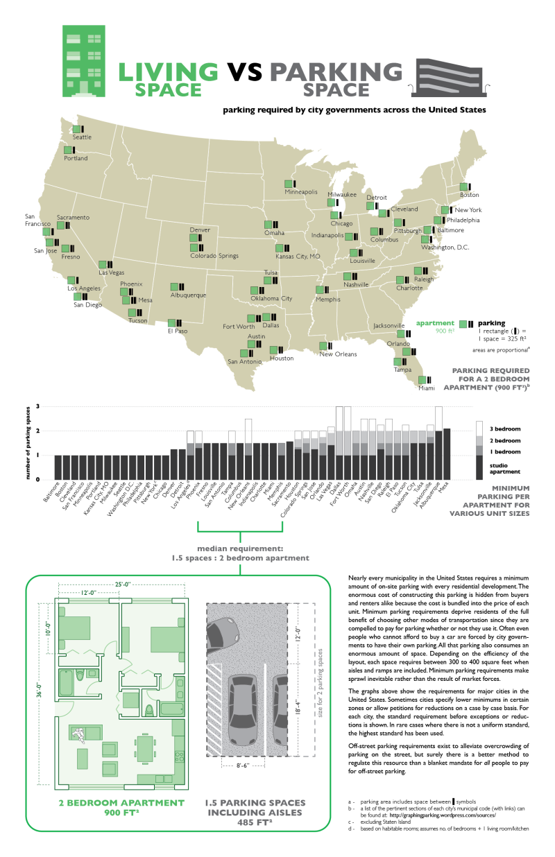
A relatively new web blog, "graphing parking", has popped up recently which aims to visually document the incredible waste and burden caused by minimum parking requirements/subsidies around the USA. I encourage everyone to check it out. Here's a sample:
Living space vs parking space (graphing parking)
Not to detract anything from Seth's effort, but I think he's going too easy on Boston here, listing it as 1:1 is not quite the right story. Although there is technically a master table of parking requirements that I've mentioned before, based on FAR, our zoning code is split up into a whole bunch of districts and each of them has their own particular tables and exceptions. I do understand that it's impossible to represent that sanely in a visualization. Instead, here's a table which summarizes a bit more comprehensively the current reigning minimum parking requirements in Boston:

Off-street minimum parking requirements for various neighborhood districts
A few notes: these requirements only apply to as-of-right development which is not subject to Large Project Review. They can also be superseded by Planned Development Areas. Each neighborhood zoning code seems to have its own way of wording things, so I've simplified a bit. These requirements only apply to normal or "other" residential development (not elder housing, etc). Some codes categorize by "1-3 units", others by "1-4 units" and others not at all. So I've settled on "1 unit", "5 units" or "10+ units" as intermediate samples.

As you can see, much of Boston suffers from higher minimum parking requirements, particularly on multi-unit buildings. I find it quixotic that larger multi-unit buildings have to comply with even more onerous parking requirements, when typically such buildings would be found in densely populated areas close to transit. I suspect that this forces most larger buildings into Large Project Review in the process of receiving variances. It's also the case that the zoning code does not distinguish between a studio and a 3-BR apartment when it comes to parking requirements. How many people living in a studio really need 2 parking spaces? Probably a very small percentage, if any.

It's pretty appalling that the North End is subject to any minimum parking requirement at all, considering that at least two-thirds of the residents do not have a car. By contrast, the South End and Bay Village have at least reduced that to 0.7 and do not require any parking for small projects.

The way Allston is lumped together with Brighton with very high minimum parking requirements is another example of bad zoning. In fact, the neighborhood boundaries don't make sensible planning areas here at all, due to geography. The sections of Allston/Brighton within a few blocks of Comm Ave -- from Packard's Corner to Cleveland Circle -- are almost all densely populated, with low car-ownership, and high transit use. Requiring 2.0 parking spaces per unit there is simply insane, and out of character with the existing built environment. I happen to know that the people who worked on this particular neighborhood code largely live in the suburban outer reaches of Brighton, and it was wrong to impose their schemes on Allston and Comm Ave.

Roxbury, South Boston and Mattapan only require 1.0 per unit even though they are less densely populated than Allston. Roxbury has a lower car-ownership rate than average, Mattapan is about average, and South Boston is higher than average. I don't know how they arrived at these decisions. But it all seems pretty arbitrary, which is a terrible rationale for a regulation that increases housing costs and decays neighborhoods.

The BRA should really revisit all of these codes and revise downward or outright eliminate any minimum parking requirements. Most of them are 20 years old. A lot has changed in the way people think since the early 90s. The minimum parking requirement is a measure intended to subsidize parking in the city, to force everyone to pay for an amenity that only some may use. Nowadays we recognize that adding parking creates traffic, that it reduces opportunity, raises housing costs, and deadens neighborhoods. There's no good reason to subsidize it; the market is perfectly capable of supplying parking to meet demand, and it should be treated as just another land use. Even places where car-ownership is high do not need minimum parking requirements: why would developers build something that they couldn't sell? Nobody expects to be given a free 200 square feet of floor space for any other use, and I don't see why parking should be the exception to that. 

Saturday, May 4, 2013

Sign of spring


The bike racks are back, and busy as ever, helping keep the sidewalk clear of piled up bikes. Perhaps they are also a sign of thawed relations with BTD, which has started acknowledging the existence of non-motorists finally, this past year. They are also supposed to install a pilot "parklet" on Harvard Ave soon, near the @Union Cafe, and paint "bike priority shared lane markings" on Brighton Ave to try and address some of the safety issues along that corridor.

Monday, March 11, 2013

Guest Street and the 64 bus

Guest Street Planning Study height and density map. Purple lines are bus routes, yellow stipples show walking distance from Union Square up to a quarter-mile. The density is far from the square.
The recently proposed car-free apartment building on North Beacon Street happens to fall within the Guest Street planning area which was re-zoned last year by the BRA and a local group of residents in the production of the Guest Street Planning Study. The main feature of this area is going to be the $500 million investment by New Balance to rebuild their headquarters and create a mixed-use district. The planning study features many forward looking ideas in an attempt to tackle the difficult problem of building a brand-new neighborhood on formerly industrial land. For example, it will permit heights up to 150' and FARs of up to 4.0 in an effort to bring life and vitality to an area devoid of anything currently. Unfortunately there are some problems, which the study readily admits:
Factors that are detrimental to its attractiveness include the area’s relative lack of public transportation access to downtown and the western suburbs, lack of identity and visibility from major streets in the area, access that is less than clear, and a public realm that is lacking.
There are two bus lines which can be said to pass through the study area, both of them infrequent and unreliable: the 64 and the 86. However, two key bus routes are nearby, both of them top-5 in ridership: the 57 and the 66. The study says:
Preserve and expand bus service. In order for the Study Area to develop at all, it is imperative that MBTA bus service be improved to provide access to Downtown, the Back Bay, Longwood/Fenway, and Cambridge. 
But it does not have any specific recommendations, beyond the new commuter rail station which is now slated to be built. There are also New Balance employee shuttles to Harvard and Kenmore, which will be upgraded according to the PNF, but they do not seem likely to be usable by the general public.

The chart at the top of this post shows the permitted heights and FARs for new development in the planning area, overlaid with the public transit infrastructure currently available. The location of the future commuter rail station at Everett Street is also shown. The yellow stipples reaching out from Union Square trace a walking path of approximately one quarter-mile (~400 meters) from the center of the square. The key problem can be easily observed: almost none of the higher density parcels can be reached within a short walk from Union Square. This seems to be the result of an unfortunate compromise which means that the existing transit resources will be furthest from the developments which need them most.

A quarter-mile is a bit of an arbitrary choice but it's a commonly cited rule of thumb when trying to figure out how far people are willing to walk to transit. What's also as important is frequency: the kind of high frequency that the key bus routes 57 and 66 provide will attract people to walk to them for many purposes. But the infrequent (and often unreliable) 64 and 86 buses will probably only be tolerable for rush-hour commuting purposes, if even that. The commuter rail station, while a net benefit, will also only provide infrequent commute-oriented service.

At this point, the question is: will the Guest Street area evolve into a car-dependent insular subdivision, or will it be able to integrate into the city's transit network in a way that reduces demand for automobile travel? In the former vision, the density will come paired with enormous parking garages (in addition to what's already being planned) and will be stifled by the already jammed capacity of North Beacon Street and Union Square. But if good alternative transportation options are supplied, then we can avoid that fate while adding much needed housing and commercial space.

I believe that to achieve good public transportation in the Guest Street area, the 64 bus route will have to be boosted and remade from a meandering coverage route into an efficient ridership-oriented line. The 86 could also stand to see some improvements. And New Balance should consider coordinating their shuttle operations with the MBTA.

Let's take a closer look at the 64 bus as it currently exists:


View in a larger map

The dark blue line is the route of the 64 bus between Oak Square in Brighton and University Park/Central Square/Red Line connection in Cambridge. The bus travels another 2 minutes to Kendall Square at rush hour. In Cambridge there is a one-way pair formed by the Western Avenue and River Street bridges. The translucent blue strips are connecting bus routes. The yellow areas on the map are sites that have been identified for development in the near or long-term future. In Allston/Brighton we have the Guest Street area, the Harvard IMP area, the Beacon Park area, and in Cambridge the K2C2 study area. The nice thing about the 64 is that it can help connect these new developments with access to the existing jobs and activities in Kendall, Central, Union, Oak Square and Allston Village, and an easy link to the Red Line and all that implies.

Nowadays, there is no consistent frequency of the 64 bus, its schedule is largely dictated by the time it takes for the assigned vehicles to complete their roundtrips. At the weekday peak, there are four buses providing approximately 23 minute headways, which reduces to two buses on 30 minute headways off-peak. In practice the headways vary from as little as 15 minutes to as much as 30 minutes during the peak, and can reach 45 minutes off-peak. The weekend service was recently reduced and features hour headways and nearly non-existent service on Sundays. It is the portrait of a bus route in decline, although the ridership is surprisingly resilient in my experience.

If the Guest Street area is going to develop as a real neighborhood instead of an island in a sea of parking lots, then the 64 bus is going to have to change. There is a mutually reinforcing positive relationship that needs to be jump-started: transit oriented development requires good transit, but the cost of providing that good transit needs good development to justify it. The service improvements will probably have to be phased and given a chance to build up ridership. Here's a few suggestions

  • The Hobart Park jog needs to go. The route forms an S-shape just north of Oak Square, where the bus suddenly turns away from Faneuil Street and sweeps around Hobart Park and under the Mass Pike. This could be accomplished in two ways, either by turning directly onto Brooks Street from Faneuil Street, or by just staying on Faneuil Street all the way to Market Street, which has the benefit of shortening the trip. This change saves resources, makes the route more sensible, and avoids tiny Hobart Street which is really not well suited to carrying buses.
  • A decision needs to be made about the current Guest Street segment, which now serves the Stop-n-Shop supermarket. Either it needs to be eliminated in favor of a pure North Beacon Street trip, or the Guest Street-running portion should be lengthened all the way to Market Street in order to serve the new developments more closely.
  • Cambridge may need to reconsider the design of the Central Square bus station, which accommodates the 64 bus. The geometry of that intersection is the reason why the 64 bus must currently divert onto Magazine Street before arriving at Central Square, instead of the more intuitive River Street approach. Increased frequency may require shuffling things around.
  • It should be possible to provide consistent 20 minute off-peak headways by adding a single bus to the route. This starts to bring it within the reasonable range for all-day usage, at least for the initial phase.
  • If the other suggestions are adopted and the route is shortened, then using the T's current assumptions, it should be possible to provide 15 minute peak headways by adding only two buses to the peak hour fleet. Again, not ideal, but getting better.
  • Other ideas could include: a 64A which short-turns at Market Street and heads back to Kendall Square; or, split the route into a coverage-oriented route 64 and a ridership-oriented route 63 (to pick an available number),
I've drawn a possible route on this map:

View in a larger map


In conclusion, the Guest Street planning study recommendations have a lot of potential to revitalize a lifeless piece of Allston/Brighton. It is unfortunate that the greatest intensity of planned development is far away from the existing transit resources, and perhaps that should be addressed directly in a revision to the study. But regardless of that, there will be a significant amount of new development taking place outside the quarter-mile "walk shed" of existing frequent transit lines. The commuter rail station will help a little bit but it is no substitute for a frequent route. The 64 bus route must see significant upgrades if this area is going to be able to reach its full potential.

Sunday, January 20, 2013

Back to the future: building homes for people, not cars

Image from presentation (source): top-left is a map of parking asphalt vs parks in the vicinity

A developer has proposed an interesting concept for an apartment on 37 North Beacon Street in Allston. The land area is approximately 18,000 square feet and is currently a used car lot and a single family home. His two main stated goals are to provide 18,000 square feet of greenery, and to avoid adding to the traffic congestion in the nearby Union Square. The first will be achieved with an array of courtyards, patio and rooftop gardens. The second will be achieved by not building parking spaces and by attracting car-free tenants.

Although Allston desperately needs more housing units for the growing population, with witheringly low vacancy rates and deteriorating housing stock, there has been some resistance to growth due to concern over traffic congestion and free on-street parking availability. Some of the more influential residents believe that every newcomer will bring more traffic and more competition for parking to the area, and these residents are willing to sacrifice the good of the neighborhood to protect themselves from that perceived menace. They have encoded their fear into a zoning code which requires 2 parking spaces to be built per habitable unit. However, the numbers do not support their case.

As we can see, Allston is one of the major car-free living areas of Boston. The American Community Survey results indicate that approximately 50% of the residents of this area do not have access to a car. In addition, traffic counts have actually declined in the vicinity of this project. This particular section of Allston/Brighton is due for some major changes in the near future: the New Brighton Landing project is already under way. The nearby Guest Street planning corridor was established to consider the future of the currently light industrial zone. The New Brighton Landing at Everett Street commuter rail station is going to be built. It's going to look much different, not too long from now.

In light of those facts, it's positively unfair to the 50% of Allston residents who live without a car to drag them down with zoning strangleholds that prevent the growth of much-needed housing units in the area.

So let's take a look at the plan for 37 North Beacon Street: 44 units, a few retail spaces at ground floor, a public courtyard and garden, and a basement storage area with room for bicycles and a few car-sharing spaces. The developer has pledged to manage the apartment building and to seek car-free tenants. I honestly don't think he'll have trouble finding any such folks, as that market is quite ripe in Allston. The location is pretty good too: 5 minutes walk from a Stop'n'Shop, 5 minutes from the new commuter rail station, 2 minutes from the key bus routes 57 and 66, 2 minutes from the thriving Union Square commercial district, and the Hubway station already in operation there.

I think the concept being proposed is very intriguing and I hope discussion improves it. I noticed several of the long-time residents warming to it, as they began to understand it. It's become clear that we need more residential units in the area, but it's also understandable that more traffic congestion is not desired. If this idea works out, it could become a model for future development which provides local vitality without the cost of increased congestion. It's a return to some of the ideas behind the housing stock which was constructed pre-Depression: a focus on the needs of people instead of the needs of cars.

More info: Floor plans.

Update: From what I've heard so far, looks like the BRA and other unknown forces are attempting to force the construction of 35 parking spaces on-site. Probably in lieu of the bicycling parking.

Tuesday, September 18, 2012

Redevelopment of Cleveland Circle Cinema

Proposed structures shown with nearby MBTA stations marked. (source: PNF)

Update: notes from the meeting.

Boston Development Group has put forward a PNF to redevelop 375-399 Chestnut Hill Avenue, a site that was formerly occupied by the Cleveland Circle Cinema which closed in 2008. The site is currently dominated by the derelict structure, a large parking lot, and an Applebee's. Part of the site is in Boston and part is in Brookline. BDG is planning to raze and rebuild the site with combined facilities for a hotel, medical office, retail, apartments and a parking garage. Here are my thoughts for the upcoming public meeting, addressed to BDG:

I am glad that BDG is working on improving the neighborhood and that they are coming to talk to the community. I'm really happy that BDG is interested in improving the walking experience around the site, by bringing the building to the street edge, and by adding a mix of uses. I hope you are serious about these intentions.

The plan is for 181 hotel rooms, 82 residential units, 19000 s.f. of medical office space, 14200 s.f. of retail/restaurant space, and 228 parking spaces (of which 141 are underground). My estimate is that the underground parking garage will cost between $5-8 million to construct.

The residential units come in a variety of sizes: the smallest is 750 s.f. (1BR), then there's a range of other sizes including 957 s.f. (1+ BR), 1099 s.f. (2BR), 1242 s.f. (2+ BR), and the largest is 1311 s.f. (2 BR). The distribution seems to be fairly even. I like this aspect, the smaller apartments seem targeted towards single professionals, but there are also a substantial number of larger apartments which seem to be adequate for families as well.

The parking space distribution is broken down into 60 hotel, 78 residential, 60 medical/retail, and 30 shared between commercial uses. This seems excessive. The PNF shows that this provision is larger than BTD's guidelines require, and it is well known that BTD's requirements are already too high. Would BDG be willing to consider reducing the number of parking spaces, or alternatively, adding another floor of residential units?

The reason I ask is that the excessive provision of parking spaces causes additional car trip generation and therefore traffic congestion on Chestnut Hill Avenue. I think it is in the interest of both BDG and the community to seek an environment which is more conducive to people and not one that is clogged with vehicles.

Along those same lines, will you do more to promote the use of the MBTA, walking and bicycling from this site? You have the unique position of being situated nearly on top of the "D" branch Reservoir station, one of the most heavily utilized stations on the surface Green Line. Residents and guests can almost literally roll out of bed and onto a trolley heading downtown. In addition to that already great access, you have the "C" branch just another few steps away, and the "B" branch a short walk down the street. Are there any additional steps that BDG can take to make transit access as convenient as possible, in order to encourage people to use it, and to reduce the number of vehicular trips to and from the site?

This seems to be one of the biggest selling points of the site to potential renters (and in the future, buyers). By comparison, just down the street at the Riverside Station, you have a major development project going on inside Newton, all because of the "D" branch. But this Cleveland Circle site has even better access to the Green Line than Riverside. For instance, I believe homes here will be extremely attractive to staff at Longwood Medical Area, people who work in Allston/Brighton, in Brookline, as well as downtown commuters. You can reach most major areas in Brighton and Brookline (as well as Back Bay, downtown, etc) from the trolleys that stop at Cleveland Circle.

Would BDG be willing to set some transit/walk/bike mode share targets for residents, employees and other users of the site? Can they implement demand management programs to actually reduce traffic congestion in the area, much the way Kendall Square has succeeded? Can they work on other ways to make walking access to/from Cleveland Circle easier?

In conclusion, I think this development is a great opportunity to grow the community in a sustainable way without impacting traffic congestion too greatly. I hope that BDG chooses to take advantage of the incredible public transportation resources that the cities of Boston and Brookline have made available to this site.

Saturday, August 18, 2012

Off street parking requirements in Boston


This is a bit of a dry subject so bear with me. Article 23 of the Boston Redevelopment Agency's zoning code establishes a base for rules about minimum off-street parking requirements, although it is subject to revision by neighborhood or other overlay districts. The basic code is fairly vague and only considers uses in a few broad categories. Minimum parking requirements are poisonous to cities, and these BRA requirements date originally to 1964: a remnant of the hideously destructive urban renewal era that lives on today. Still, there are a few interesting features. For example, it appears that they've made an effort to reduce, if not outright eliminate minimum parking requirements, for higher density areas. Check out the table of requirements for Residential developments, indexed by Floor Area Ratio (FAR), which is a measure of how efficiently a particular lot is utilized:

  • Maximum FAR = 0.3 or 0.5: 1.0 space per dwelling unit
  • Maximum FAR = 0.8 or 1.0:  0.9 spaces per dwelling unit
  • Maximum FAR = 2.0:  0.7 spaces per dwelling unit
  • Maximum FAR = 3.0:  0.6 spaces per dwelling unit
  • Maximum FAR = 4.0:  0.5 spaces per dwelling unit
  • Maximum FAR = 5.0:  0.4 spaces per dwelling unit

There are some additional details: if Maximum FAR is 8.0 or 10.0 then there are no minimum parking requirements. And if the formula would produce only 2-4 parking spaces, then the requirement may be waived in some cases. So, it appears there has been some effort to mitigate the negative effects of parking requirements in the more densely populated areas.

Unfortunately, it does not go far enough. Minimum parking requirements should simply be abolished completely. They have an overall negative effect on the city, and also destroy a perfectly viable private market for parking. To get an idea of why this attenuation isn't sufficient, consider the North End. There, the zoning code specifies a maximum FAR of 3. According to this basic code, if the North End were being built today, then they would have to build 0.6 spaces per dwelling unit. Many of the blocks in the North End have dwelling unit densities ranging up to nearly 180 per net acre. By these requirements, there would have to be provided 108 parking spaces per net acre as well. The code also specifies that each parking space must be 8.5' x 20' (fairly large) which means 18,360 sq feet would have to be devoted to parking spaces, not including access lanes. A FAR of 3 means that there is 130,680 of square footage provided in a net acre.

Example North End block after minimum parking requirements applied.

So, according to these rules, approximately 20% to 25% of the residential space available in the North End would have to be devoted to parking! It is utterly inconceivable that the North End could be the friendly, walkable neighborhood it is today if it had been built under this regime. Luckily, much of it was built up long before the advent of poisonous zoning codes. What's even more curious is that even though the North End is now protected as a Restricted Parking District, there is still a 1 parking space per dwelling unit requirement in the neighborhood-specific zoning code. This is actually worse than the generic code!

Shifting to another neighborhood, Allston-Brighton, its code has non-density sensitive parking requirements specified in Table J for a wider variety of uses. For example, restaurants are required to provide 0.15 parking spaces per seat. And residences are required to provide 1.75 spaces per dwelling unit, unless there are 10 or more dwelling units in the building, in which case, the requirement goes up to 2 spaces per unit. So higher density forces more parking on the site, which is rather strange. At least it does not seem to specify parking requirements for bars explicitly, though I would not be surprised if they are grouped under another category.

I have to wonder about the relevance of this zoning code however. There are some decent parts contained within, to be sure. For example, there is an emphasis on creating a "street wall" in various districts and some like-minded attempts to keep the neighborhood walking-friendly. In other ways, it is far too restrictive and overly burdensome. I know of apartment complexes on land zoned for "3 Families" which also do not abide by the parking requirements (thankfully!). It is possible that they predate the urban renewal era, like much of the remaining decent housing stock in Boston. But what's even more questionable is the list of permitted uses in Table B. Supposedly, the following uses are banned in every case: bars with live entertainment, dance halls, and restaurants open after 10:30 p.m. Yet, a quick walk in the commercial district would confirm that all of these types of businesses do exist and thrive in Allston. The zoning code is very much out-of-touch with the reality of the neighborhood, as any static document would be. It needs to be reformed greatly, with an emphasis on removing the overbearing and intrusive prescriptions on usage which do not serve any public safety interest, but only the moral agenda of a few stodgy busybodies.

Thursday, July 5, 2012

Quincy Center takes an inadvertent step forward

The Quincy Center station parking garage, which saw approximately half of its 872 spaces used on a weekday basis, is now closed indefinitely due to unsafe conditions in its 41-year old crumbling structure. One stop down, at the Quincy Adams station garage, there is approximately 75% weekday utilization of its 2,538 spaces, so there should be plenty of room for Quincy Center garage users. The Quincy Adams T station is a relatively newer infill station along the Braintree branch of the Red Line.

On a broader note, Quincy Center is changing and attempting to reinvent itself as a more urban neighborhood, in a big way. The garage there clearly did not serve that goal. In addition, the Quincy Adams garage is placed near the intersection of I-93 and Route 3, which is a much better location for a park-n-ride that needs to be able to accommodate and discharge thousands of vehicles in a limited span of time. The Quincy Center station is further up along the Burgin Parkway, which is a smaller arterial road, and not nearly as convenient for cars coming from the south. That is probably why the garage has seen relatively light usage compared to the other park-n-rides along the Red Line, even when it was open. Although I believe this closure was serendipitous, hopefully it will fit right into the plans for the renovation of the Quincy Center area, which is well positioned for a revival.

Thursday, June 21, 2012

The automobile empire strikes back

I was thinking about a recent Boston Globe column attacking the Mayor's "parklet" initiative while riding the bus this morning when I observed a curious event. Someone was exiting a parallel parking space while someone else was waiting for it and blocking traffic. The bus was trapped at the curb while this was playing out. Finally, we got free, and passed the woman who got her parking space she had so desperately wanted. And three cars later, I spotted an empty parking spot she could have taken instead. Figures. But as we went on, I saw more and more parking spaces that were empty. I counted approximately 14 available parking spaces within those next 3 blocks. The whole mess could have been easily avoided if only the driver had the foresight to look ahead.

Brian McGrory of the Boston Globe has a problem with finding parking that could also be resolved with a little forward thinking too, if he were to choose to exercise it. He writes:
``By my admittedly inexact count, and please don’t hold me to this precise number, there are a grand total of six unrestricted parking spaces remaining on city streets these days, and about 3,000 cars circling the block waiting for them to open up. Funny part is, the owners of the parked cars are sitting in them sending text messages to friends saying they can’t believe the parking space they found. 
And now, in the face of this unprecedented shortage of street parking, our mayor comes along with a stunning new idea. He wants to take the few remaining spaces that we have, install flooring over the pavement, bring in patio furniture and planters, and call them “parklets.” This is terrific. While we’re at it, let’s put a swimming pool on the median strip of the Southeast Expressway and cut the highway down by a lane.''
His complaint is ostensibly with the space set aside for commercial vehicles, taxis, tour-buses, food trucks, police vehicles, diplomats, 15-minute parking, and now "parklets" -- which are parking space-sized public parks being deployed during warm weather. However, the outlandish tone of his column, and excessive attitude expressed within, suggests that his real agenda is to strike a blow for the cause of suburban automobile drivers at the expense of city residents. Further on:
``The car is still banned from Downtown Crossing, even while it’s painfully obvious that the hard luck neighborhood would benefit enormously from vehicular traffic. Cities around the country have turned their tired pedestrian malls back into real streets with great success. Not Boston. The car is constantly ticketed. The car is pushed into increasingly narrow lanes to make room for bikes.''
Filene's "Memorial Hole"
In contrast, whenever I visit Downtown Crossing I am amazed by the numbers of people walking around there despite the gigantic gaping fiasco that is the Filene's Memorial Hole. The location is a transit hub that sits on top of the major nexus of the Red and Orange lines as well as several bus routes. What the neighborhood there needs is relief from overbearing zoning restrictions (which does seem to be happening) and an end to the games played by the developers who abandoned their property and their obligations to the city. Indeed, there are already companies choosing to relocate to Downtown Crossing. Furthermore, I think Mr. McGrory will probably not be happy to learn that economic development benefits far more from setting aside loading zones for commercial vehicles rather than simple street parking, which isn't that effective at fitting cars anyway.
A makeshift "pop-up park" being enjoyed by about 10 people

The fact is, a parking space requires approximately 200 square feet, a space which can easily fit more than a dozen people comfortably. Businesses that depend upon attracting customers will quickly recognize that an appropriately placed "parklet" is a much greater economic boon to them than a street parking space. I have already had the opportunity to witness this in action at a temporary Sunday "parklet" in Allston that was sponsored by a local bicycle shop in conjunction with a cafe. There were over ten people enjoying the space at one time, which rivals the patronage of that parking space over the course of an entire day. I saw someone packing up a bass violin, it seems I had just missed some live music as well. The city's plans are much more refined than this particular example and are coordinated with the local business for clean-up and safety responsibility. So I am looking forward to further expansion of the program. I know I have been critical of "greenspace" in the past, but I think this "parklet" program is the opposite of useless, empty "greenspace" because it is placed right where people will use and enjoy it. And that's what's crucial.

Stepping back a little, this attack on the city ties back into a larger effort to undo decades of attempts to mitigate the negative effects caused by automobile traffic in the city of Boston. After the $22 billion taxpayer-subsidized Big Dig made it so much easier to drive into the city, it was inevitable that people would begin to demand additional subsidized parking spaces. To help avoid the fate of further bulldozing the city and submerging it into a cloud of smog, a "parking freeze" was adopted in Boston proper, in accordance with the Clean Air Act. But, as Fred Salvucci noted at the Bowker Overpass meeting, it is a very "leaky parking freeze." Earlier this week, there was a great example in Commonwealth Magazine: an article about a proposal by Mass Eye and Ear to build a giant parking garage and a demand that the state spend $30 million to relocate Storrow Drive. This land lies within the Boston proper parking freeze, but it is almost powerless in the face of such political forces. Similarly, State Street obtained a $12 million subsidy to build a parking garage in the Fort Point neighborhood which is supposed to be under the jurisdiction of the South Boston parking freeze. But these freezes seem to be no more than light autumn breezes when the well-connected come around, backed up by road raging columnists. The residents of the city are the ones who lose the most from these deals, being forced to live with the blight and the smog generated by all this car infrastructure, and the broken promises to make it right.

If city hall was truly interested in solving the street parking problems without damaging neighborhoods and without hurting city residents, then they would consider adopting the common sense reforms proposed by UCLA professor Donald Shoup: moving the provision of street parking towards a free market solution where prices are set based upon demand, just like with any other product or piece of private land. Street parking is generally a "tragedy of the commons" problem, and like all such problems, it can be solved by introducing a proper and well-delineated market for managing that resource. Without this change, it is likely that the political forces that push parking lot socialism will eventually get their way and force the city to subsidize a larger supply of parking at our expense.

Friday, June 15, 2012

Residential street parking

We have a love-hate relationship with street parking in cities. On the one hand, it's convenient when available, it provides a safer way to use up space on overly wide roads, and offers some potential protection from moving traffic. On the other hand, it's almost always short in supply, creates potential blind spots where children might be present, and becomes a flash-point in neighborhood discussions about new growth and development.

A common theme I often hear at community meetings and read in newspaper articles about proposed new buildings is: "what will happen to our street parking?" And I don't just mean through changes to the streetscape. Folks at these meetings are worried about losing "their" access to street parking because of added "competition" for finding spaces. The sense of ownership that residents exercise over pieces of the public right-of-way becomes an impediment to necessary changes and growth in the neighborhood. It's a perverse situation that comes about because of the confused nature of the not-quite-public and not-quite-private feature of street parking. And there will always be political pressure of this form as long as street parking is permitted, because of the basic geometry of streets and blocks.


What do I mean? Well take a look at the example block from the North End I have shown above. According to the census, there are 173 dwelling units and 293 people living on this block, mixed with a few shops, which encompasses approximately 1 acre of land. There are 37 parking spaces distributed around the perimeter of the block. There is also a garage underneath one of the buildings, and I don't know how many spaces are in there. Still, there's probably no more than 1 parking space per 4 dwelling units. This kind of ratio would never be tolerated even under supposedly more enlightened zoning codes these days. Now, the North End is a pretty walkable place that was urbanized centuries before the automobile became dominant.


Very close-by is another example where over half a block was leveled to build a parking lot. The density is on the remaining portion is approximately equivalent to the previous example. The parking lot employs a valet who double-parks the cars, providing at least 80 spaces without blocking the access lane. The perimeter street parking follows similar ratios, except for the curb cuts. There are 102 potential parking spaces visible in this picture, giving a 2.5:1 ratio of spaces:dwelling units. So it is likely that some of the residents of other blocks use this parking lot to store their cars. There still must be a high proportion of residents who walk and use public transit exclusively, though. And thankfully, since most of the North End does not look like this, that kind of lifestyle fits in well.


This example comes from South Boston, which is far more car-oriented than the North End. Again, the entire block is about 1 acre, but this time there are only 43 dwelling units on the block. This is largely because the buildings are shorter, being only 2-3 stories instead of 4-5 stories, and some other design differences. There are 35 street parking spaces and at least 9 off-street spaces (maybe more with double-parking). That's a 1:1 ratio. Although there is a frequent bus route less than a quarter-mile away, it is likely that every apartment here has at least one car (the exception may be caused by the upper-right corner, which appears to have its off-street spaces devoted to that one set of units). One curiosity about this particular block is that the side streets are actually smaller than those shown in the North End example: there is only space for parking on one curb. In general, most South Boston streets are much wider than North End streets. That means the adjacent block shares street parking with this block. There is a larger off-street parking lot on one of them, which probably helps to make up for this.

The density difference is pretty stark between the North End and the South Boston examples. The 171 dwelling units per net acre of the North End produce a very urban, walkable neighborhood. The 45 dwelling units per net acre of the block in South Boston, which is fairly typical, falls in a range which still drives people to use their car for most trips. And it results in some of the most ferocious fights for street parking in the country. If you require every dwelling unit to be paired with some street parking availability, then you are going to be restricted to this 40 unit per acre maximum. And unfortunately, it seems that this number is simply not enough to generate sufficient city vitality in most cases.

Suppose you decide instead to end the practice of street parking, as is done in Tokyo. Is one solution to allow developers to sacrifice the first floor for a garage, San Francisco-style? It can potentially squeeze more cars into the same space and not sacrifice as many dwelling units. But if you force every parcel to be like this then what you get is a lot of nasty curb cuts and the garage wall effect. And then people loathe walking in such a place, it encourages driving everywhere, and the streets become dangerously clogged with cars.
"Garage wall" effect (src: Old Urbanist)

One possible way to alleviate the speeding problems is to make the streets Japanese-style, no more than 10-14 feet wide. You can do away with the curbs and share the streets with people, eliminating that problem too. Plus, that can make up for some of the space lost to parking garages, since asphalt coverage will be under 20% or so. That still doesn't eliminate the garage wall effect, but that could be made up for in more creative ways.

Seijo street (src: Nathan Lewis)
The important part is that nobody should be forced to build parking. Spaces would be just another piece of floor area for sale or lease. Owners of parcels near good public transit may find it more economical to not build parking, while those of parcels far from good transit might choose to add extra. With parking on the free market, there's nothing stopping a person living in one building from renting or purchasing a space in another, nearby parcel. Indeed, just a few months ago, one developer offered to make that kind of arrangement within his own properties on one block here. There's no reason why that shouldn't be more common, treating parking spaces as a commodity, to be bought and sold on the market -- instead of being forcibly supplied by overbearing regulations.