Pages

Showing posts with label community meeting. Show all posts

Monday, June 15, 2015

Might does not make right

Years ago, when I was learning how to drive, my mother made sure to emphasize the fact that a motor vehicle is a lethal weapon. Nearly two tons of steel and plastic, moving at speed, is dangerous when misused or mishandled. That's not cause to be passive, but rather, to be cognizant of the consequences and continually vigilant. As a teenager, it was easy to get excited about the new power available to me, while not considering the risks, nor giving thought to others in the world around me -- except as obstacles. And like most Americans, I managed to make it through those years without serious incident, despite some mistakes, with the help of a few lucky breaks here and there. Because I was okay personally, I didn't think much beyond that, at the time.

Having spent several years on walking, bicycling and transit advocacy, I have a different, "outside-the-windshield" perspective on these matters nowadays. The power of the motor vehicle I can still appreciate, but I can also see how it is too easily abused. With one barely perceptible pedal push, a driver can blast past a child waiting at a crosswalk, and hardly notice at all. Or seeing brake lights ahead, a driver swerves to pass the one car that had yielded, and barely skims past a person crossing the street. The noise, grit, and grime caused by the passage of fast-moving motor vehicles is out-of-sight, out-of-mind to those drivers that create it. Even if nobody is physically harmed, the physical characteristics of living environments that facilitate speeding, heavy vehicles are unfriendly to human beings.

To behave humanely behind the wheel takes hard work, and a commitment to consider the other people around you. "Might does not make right" is the ethical principle that I believe is most applicable to transportation projects in our cities and towns. My feeling is that we have an obligation to protect the vulnerable from the powerful, and not only to protect, but to promote and serve. That is what forms the ethical basis of what I try to do.

The coalition of people who promote automobile interests are usually very strong, very rich, and very powerful. Motor vehicles are expensive to own, to maintain, and are highly wasteful of space. Any available room on the roads is quickly consumed by even a small increase in the number of vehicles. The resulting congestion can be enraging to drivers, as their expensive and powerful machines are trapped in a mire of their own making. At both home and destinations, without a readily accessible 300 square-foot piece of land for storage, these machines become a enormous burden on their owners, who then proceed to lash out in frustration.

Automobiles can provide convenient and quick transportation when everything works out, but when the systems quite frequently fail, the problems that stack up are often 'solved' at the expense of other people, especially the most vulnerable. Sidewalks are narrowed. Trees are cut down. Crosswalks eliminated. Bike facilities are completely omitted. Fences are put up. Transit is dis-invested. Highways are blasted through neighborhoods. Children aren't allowed to walk to school, or the park. Desperately needed housing development is canceled for imagined fear of "parking problems." Economic growth is stifled because "it might cause traffic." We can no longer properly build cities for people because all of our modern rules and regulations are designed to produce cities that only a machine could love.

Motor vehicles are powerful, and many of the people who own them are powerful. Motor vehicles are also very useful, and are a great boon to our civilization when used safely and prudently, within reasonable limits. But that does not make it right to give in to their every need. Without check they would take away our land, our natural resources, and the quality of our air. Thankfully, over the past several decades, the work of countless citizens has produced some legislative and political help, through endless community organizing. It's a continuing effort, and it's very important that everyone participate. Being obstructive is not enough: a great deal of damage was done by the Utopian automobile idealists of the 1950s who never gave any thought to the communities that were harmed by their schemes. That damage has yet to be repaired in many cases.

To give a concrete example: on June 17th, MassDOT will present the latest installment in the ongoing saga to rebuild the Allston Mass Pike interchange (6:30 pm, Jackson-Mann school). Fifty years ago, the Mass Pike extension widened the railroad right-of-way, taking houses, and leaving behind a huge scar across the Allston/Brighton neighborhood that has never been properly managed. The crossings are decrepit and crumbling, and not accessible to many people with disabilities. The streets that were rebuilt back then were given designs that had almost no consideration for people on foot, much less on bicycle. Dangerous highway ramps cut in at sections that seem to be designed to interstate highway-spec, despite being city streets.

Some bike lanes were painted in an effort to try and do something, anything at all, but despite the well-meaning effort, the street remains a major problem.
Two years ago, the Patrick administration announced a project that had the potential to fix all kinds of problems with the interchange. A dangerous curve in the highway would be straightened. The old-fashioned tollbooths would be replaced with modern, automated systems. The whole mess of city streets left behind by the 1960s extension project could be reworked, finally reuniting North Allston with south, and building a whole new neighborhood in between. And to top it off, a new 'West Station' on the Worcester line would finally give Allston back a railroad station somewhat near the site of the original station around which the community was founded.

But it seems that potential is being squandered. Despite months of community engagement and a professed commitment to "multi-modal thinking", the design team went off for the winter and nothing came out until finally this June meeting was announced with this plan shown, that seems to have more space allocated to roadway than non-roadway:
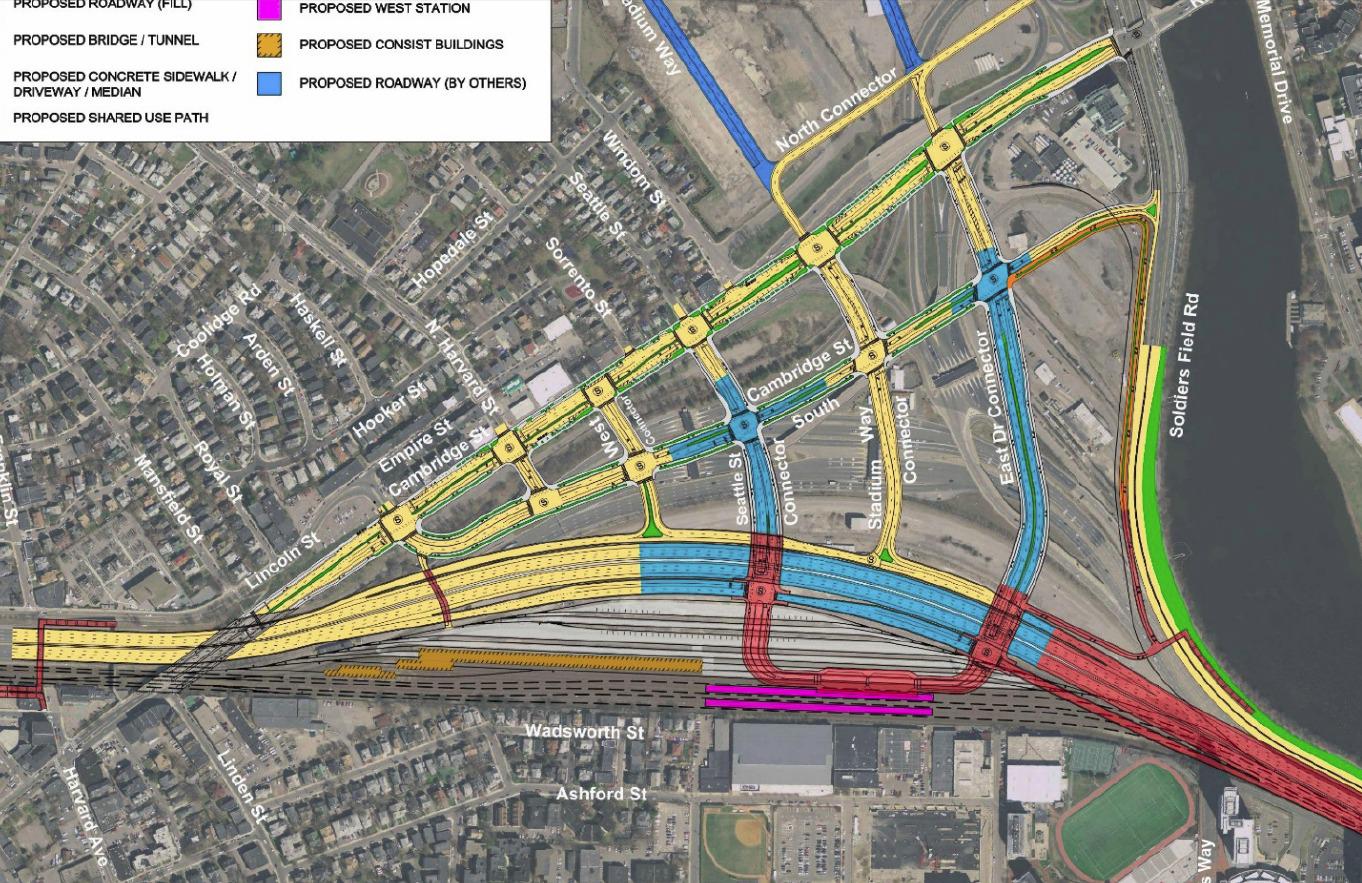

In the past year, the DOT design team told us often that they "don't do city planning" and it appears that they don't intend anyone else to do so either. It's hard to imagine anything neighborly fitting between those massive connectors (that will rise on earthen berms above grade, by the way). West Station is included, but can you imagine making the connection to or through that while walking precariously on a pathway above 10-12 lanes of roaring highway and some number of railyard tracks? This design is a highway design, engineered for the comfort of drivers first, and everyone else second. Yes, it's an improvement over the old ways, in that it will all satisfy accessibility regulations, and there are connected sidewalks and protected bike lanes. But with this car-first design, it seems that those facilities will only be used by necessity, not by choice.

We have often been told that "the computer models" require this many lanes, or that size an intersection, etc. The models, of course, have been programmed by engineers to try and predict the future. They say that they can tell us what the behavior of people in the year 2035 will be, with precision. They will tell us that unless they build all of this road space, we will be threatened by some kind of 'traffic armageddon'. It's a bullying tactic, plain and simple. Common sense should tell anyone that trying to predict the future is impossible, much less making precise predictions about conditions on a particular road 20 years from now. The models that they create are nothing but a set of equations and parameters chosen by the people who designed it. These models are as fallible as the people behind them, and can be used to say anything at all. Usually, they are used to say whatever it is the people who hired the modelers want them to say.

In this case, the powerful have spoken, and they have said that they want more automobile capacity in our neighborhood, at our expense. Whenever you hear an engineer say "the models predict increased traffic by X" what you should translate that to is "automobile interests want increased capacity by X, and nothing else matters."

Let's contrast this situation with what it might be like if MassDOT took the other side and tried to help provide space for a new neighborhood with good connections to the surroundings. Then the street network would be laid out at a human scale, with smaller blocks, smaller streets, and a collaboration with city planners in Boston. When it came time to talk about automobile capacity, instead of sending us an ultimatum that "we must tolerate a massive additional influx of vehicles or else", they would calculate the maximum capacity that is compatible with the city planning goals, and work to keep demand for the highway under that level. For example, perhaps it could be considered that commuter bus or train tickets should not be more expensive than paying the toll on the highway. Or that all employers that offer parking benefits must also offer 'parking cash-out' as a benefit for people who chose not to drive.

The reason that this way of working is so tough for them to do, politically, is because it requires that they go to the powerful automobile-promoting interests and tell them: there is a limit, and beyond that, demand for the road is going to have to be managed somehow. An ever-increasing level of traffic on the Mass Pike is not an inevitability. That will only happen so long as more capacity is forced on us, so long as officials are too timid to use the tools of transportation demand management to control the problem at its source, and so long as might makes the right-of-way.

Sunday, March 22, 2015

Comm Ave Phase 2A public meeting: Tuesday March 24th


March 24th, 6 p.m.
565 Commonwealth Ave (Kenmore Classroom Building)
Room 101

The city is holding their long-awaited Comm Ave Phase 2A public meeting on Tuesday. This deals with the segment of Comm Ave between Packard's Corner and the BU Bridge (non-inclusive). One of the biggest topics of contention has been whether or not the bike lanes would finally be fixed on Comm Ave to match the Boston Bike Network plan for having a protected bike lane on Comm Ave.

The status quo
Good news seems to be that they will be presenting some kind of protected bike lane option at the meeting, so that represents a major step forward for the city. The precise details remain to be seen.

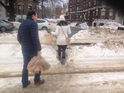
Another one of the major problems on the street is the lack of a crosswalk at Alcorn Street and Naples Road. On one side is a densely populated residential area, on the other side is the neighborhood supermarket. Most people simply wait and cross the street over the tracks when clear. But, the engineers believe that people should be walking over 1,000 feet out of their way, traversing 6 extra traffic lanes and waiting through extra cycles of the traffic light, simply to get across the street. While carrying heavy bags. This is a clear case of a disconnect between the planning department -- who only see this street on paper -- and the people who live here.

Even in the heavy snowfall, people would still rather cross here than go around the long way.

(source)
So, while there has been a great deal of progress made on the design, compared to where it was 3 years ago, there is still some more to go.

Finally, I would like to mention that although the MBTA has finally put out a plan for much-needed station consolidation, it is not clear that they will be ready to go before the city starts the reconstruction project. That will put us in the absurd situation of rebuilding the street around the 4 old stations. Then, presumably, the MBTA will come along and cut those out, and rebuild 2 properly accessible stations, but at that point they will simply leave the old station locations as dead space. That's a terrible waste, and a lot of extra pain too -- as the time period of construction would be lengthened. It seems to make a lot more sense to simply get both projects done simultaneously, so that the new street doesn't have to waste space, and so that the station construction can proceed in parallel with the street reconstruction, in a fully integrated fashion.

Saturday, May 17, 2014

About the upcoming annual Green Line forum on May 28th: recommendations and a call for action


Senator Brownsberger is hosting another Green Line forum this upcoming May 28th, 6pm, at the BPL Copley Rabb Lecture Hall. Hopefully the room will be packed with riders able to demonstrate the importance of the Green Line and fixing its numerous problems. In past years, the experience has been interesting. A good sized crowd showed up last year. Several of the speakers made some very good comments. I remember the first person to speak was a father, who brought his young son, they both stood up at the front of the room and he called upon the MBTA officials to implement signal priority: why should a train filled with hundreds of people have to wait for a few cars?

On the other hand, several of the speakers made some truly bonkers comments. Like one older gentleman, who said he had been riding for forty years, but for some reason was upset at the fact that he saw empty 2-car trains sometimes. The MBTA official who responded actually handled this one correctly, and she pointed out that an empty train in Brighton could easily be a full train further down the line.
"off-peak"

Unfortunately, the MBTA did not handle it correctly when another crazed speaker whined about seeing one or two people sneaking in the rear doors. The MBTA continues to punish all riders collectively, despite having no evidence to back up their reprehensible "front door only" policy. Refusing to open the rear doors causes massive delays and train bunching, but the MBTA clearly has no respect for the paying customers, nor for their own wasted money on overtime as delays pile up. The correct response would have been to say something like: "the importance of following schedules and keeping dwell times low far outweighs the possibility that someone might sneak in the rear door, and anyway, we are going to implement proof-of-payment soon!"


Ultimately, what came out of the process last year was a letter from Dr. Scott that briefly responded to a few issues but made very few changes. The real headline grabber was the announcement of Green Line tracking in 2015. There were a few passive changes to signalization: I noticed the change at Packard's Corner before I read the letter, actually, so I suppose it has helped a tiny bit. But that was it. We are still waiting for the public process on station consolidation, although I have heard more rumors of it brewing lately. There has been no movement on the signal priority front, despite its great potential, and despite the fact that Huntington Ave is fully modernized and ready to go anytime the T wants to try (unlike Comm Ave). And all-door boarding/proof-of-payment seems to have disappeared off the agenda entirely, although it has huge potential for accessibility and schedule-keeping improvement.

Commonwealth Ave reconstruction phases
For this year, I think we can do better. Phase 2A of the Comm Ave rebuild is going to be funded starting in October, and that will open up all kinds of possibilities, because it involves reconstructing a segment of the "B" branch that has the most closely spaced stations. I would say that the items we need to focus on pushing the MBTA to consider are:

  • Station consolidation, as described in this blog post. We need to bring the station spacing up to modern standards, which is closer to 1200-1400 feet than the current 725 feet. This will help improve speeds and simplify operations. It also reduces the number of stations the MBTA has to bring up to ADA standards, and it also frees up space for use by pedestrians and bicyclists on Comm Ave.
  • Signal priority to help reduce the schedule unreliability caused by capricious traffic signalization. This does not have to be as preemptive as Houston's in order to have a positive effect, although it would be appreciated!
  • All door boarding, if not full blown proof-of-payment. There's a few ways to go about this that don't require proof-of-payment to be implemented. For example, fare inspectors could stand in the back of random Green Line cars and ask to see the pass of anyone who steps in the rear. I know this is feasible because they used to do it on a regular basis! In the future, I think the T would be best served by implementing MUNI-style proof-of-payment, though, which basically is cash-up-front and CharlieCards-at-all-doors. Then the T should also encourage the purchase of monthly/weekly passes as much as possible. This approach is the best for both revenue protection and schedule protection, in my opinion.
  • Easy access to stations and platforms. Unfortunately, the MBTA has a terrible habit of destroying accessibility whenever they "modernize" a station. If you look at the rebuilt stations on the Green Line, many of them are harder for a pedestrian to access than the older asphalt strips. So, while they abide by the ADA legal requirements, they do so in a manner that is as obnoxious as possible. This is insane. The MBTA needs to recognize that station access time is part of every rider's journey, and optimizing it is just as important as getting signal priority or other improvements done right. In short: every MBTA platform should have at least two exits/entrances: one at either end of the platform, with crosswalks (signalized or not) to the sidewalk. Walking to the station from any direction should be achievable with as straight-line a path as reasonably possible. Nobody should ever be forced to walk 200 yards out of their way to access a station because of a stupidly placed fence. That's valuable minutes wasted (and even worse for seniors or the disabled) that could determine whether someone misses a train, or even bothers to ride at all!

The Commonwealth Ave jail: the punishment inflicted by the MBTA on riders
My suggestions spring from a simple philosophy: riding the Green Line should be as easy, accessible, and reliable as possible. Everything I advocate for comes from that principle. I know that people like to dump on the Green Line, but it actually has a lot of potential that is simply wasted by the MBTA. Fact is, the Green Line has a major advantage over buses and streetcars: it has dedicated lanes (mostly). And the Green Line has a major advantage over subways and elevated trains: it is on the surface, which should make access easy if the MBTA would only allow it, no stairs nor elevators required! If you consider door-to-door journey time, then with signal priority, all-door boarding, and station consolidation combined with convenient station accessibility, the Green Line could be quite competitive with full blown subways.

I hope that people will show up on May 28th and advocate positively for improvements to the Green Line; improvements that will truly benefit the 30,000+ people who ride it every day. You are welcome to use any of my suggestions, and I look forward to hearing some of yours as well.

Wednesday, January 15, 2014

Follow up to Jan 14th public meeting about Cambridge Street overpass


Yesterday was the third and, we believe, final public hearing about the Cambridge Street overpass repair project (MassDOT #606376). I would estimate that close to a hundred people showed up to hear about some major changes were made after the second meeting back on Nov 19. The Boston Globe summarized some of the changes, also shown in this cross-section:


MassDOT engineers decided to create the crosswalk at Mansfield Street but in order to build the accessible ramps, they realized that the bike lane would need to be raised onto the sidewalk. So they decided to create what may become Boston's first sidewalk level cycle track. I believe that the crosswalk and the cycle track are both positive changes, but there still remain issues to be addressed. Many of them were covered by people who spoke up at the public meeting, for a solid two-and-a-half hours of testimony:


  • The fence in the median is bad, unsafe, and ugly, and it must go. People want to cross the street, and will do so anyway by skirting the fence, but less safely than they do now. Plus, crossing at Linden Street is not illegal, therefore the fence is blocking a legal movement in favor of an illegal movement: speeding. MassDOT: we think our current design is safer.
  • 99% of 30 mph streets do not have a fence down the middle. Fences will inspire speeding.
  • We love the crosswalk. Can a temporary one be installed as soon as possible? We don't want to have to wait until 2017 to have a crosswalk there. MassDOT: difficult because of bridge joint.
  • The cycle track is a great step forward, but it changes the worry from car-on-bike to the possibility that there might be too much contention between pedestrians and cyclists.
  • The shoulders are now 3' wide in the new design. Could some of that space be reallocated to the sidewalk so that pedestrians have more space? Wide shoulders encourage speeding. MassDOT: we want that for breakdown space.
  • Revisit the shoulders, narrow the lanes, find more space for pedestrians. The outer lane feels like it is effectively 14' which promotes speeding.
  • The new lanes are 11' but on the River Street bridge you have small shoulders and only 10.5' lanes. Why not here? Wide lanes encourage speeding. MassDOT: we obtained exceptions for River Street bridge and don't want to do that here since there is room.
  • Speed is the main issue on this street: how do we bring it down to 25-30 mph?
  • There is a street light that juts into the cycle track every 100'. Can that be avoided? MassDOT: light poles must be outside of crash barrier.
  • The Lincoln Street intersection has a bike box in the new design, but it seems to be awkward and unlikely to be used. That intersection is barely functional for pedestrians and needs to be fixed. BTD: will take a look.
  • How will you prevent moped riders from using the cycle track?
  • Will you ensure that no gray boxes or other typical obstructions block up the sidewalk?
  • Cambridge Street shouldn't be a barrier for the community.
  • If you're going to put a fence, can you open up the Allston "subway" under the Pike, at least?
  • Expect 2-way travel on both cycle tracks, because of limited opportunities to cross the street.
  • MassDOT claims that the Franklin Street footbridge is going to be redone starting in about 3 years.
  • A bunch of trees were cut down from the embankment. Will they be replaced?
  • We need a snow clearing plan for sidewalk level cycletracks (and sidewalks).
  • The city intersections at either end of the scope need to be fixed -- ASAP.
  • How often are vehicles disabled? Does it really justify a 3' shoulder when most of the time it's not going to be used?
  • Hold off on the fence until after complete, then do a study to see if it is really necessary.
  • Will MassDOT promise not to use this "repair project" as an excuse not to redo the entire overpass if the $250m Mass Pike Interchange Improvement project decides that is necessary?
  • MassDOT: commits to study replacement of entire overpass as part of larger project, and will not use anything on this project as a hindrance to rebuild.
  • Will the crosswalk really work when traffic is going 40-50 mph? MassDOT: claims that new crosswalk strobe lights are studied and certified by FHWA for this purpose.
  • Business owner has seen numerous crashes and deaths on this street because of cars going too fast. Must re-envision this street as a city street, no more than 30 mph. Add traffic light at Linden Street, one that is timed with Harvard Ave.
  • MassDOT: commits to work on temporary traffic calming measures at dangerous entrance to Mass Pike (out of scope though).
  • Harvard/Franklin/Cambridge Street intersection needs to be calmed down. It is very aggressive as designed.
  • This current design is very utilitarian. This is a gateway. Consider public art and better lighting. MassDOT: this is fanciest fence we have, but we will look again.
  • How long will the crosswalk be given? MassDOT: 26-30 seconds on pushbutton activation.
  • Have you considered additional traffic generated by New Balance? MassDOT: Cambridge Street is massively over capacity as it is right now, and maintaining the right-turn lane at Franklin Street is intended to help New Balance traffic.
  • If you must keep the median fence, consider a 4' fence instead of 6' one. End the fence 3' before the end of the median, just for safety of people who will cross anyway. Consider a blinking yellow overhead light that says "Traffic Light Ahead" to try and warn people speeding over hill.

Comment period ends January 24th, 2014. Please reference "Project #606376 Cambridge Street bridge over I-90, Allston, Boston" and write an e-mail to dot.feedback.highway@state.ma.us. Or snail-mail:

Patricia A. Leavenworth, P.E., Chief Engineer,
Attention.: Bridge Project management, Project File No. 606376. 
MassDOT
10 Park Plaza
Boston, MA 02116

The engineers expect to submit final design for review by the end of this month and to put it out for bid so that construction can begin this spring.

Monday, January 13, 2014

Final Cambridge street overpass public meeting Tuesday Jan 14th


Please come and offer comment on the Cambridge street overpass repair project: Tuesday, Jan 14th, 6pm, at the Jackson Mann school 500 Cambridge street in Allston.

See also the website FixCambridgeStreet.org.

The new plans still call for a fence down the median of the overpass, and no crosswalk near Linden street.

Take offense to the fence, come and tell the officials what you think.

Monday, November 11, 2013

Help make the Cambridge Street overpass safer and better

MassDOT has called a second public meeting on the Cambridge Street overpass replacement with some updates. They intend to issue the notice to proceed in the early winter.


Despite some changes, the plan still calls for a fence down the middle of the street, blocking pedestrian crossing for over a quarter-mile. The plan does not address any of the existing ADA incompatibility issues, and it still calls for mixing of walkers and multiple streams of bikers by the Franklin Street pedestrian overpass.

Several advocates and community members have written a new public letter to the agency calling for more changes to the design. I encourage everyone to check it out and sign it, particularly if you live in the area. I also encourage everyone to come to the public meeting on November 19th, at 6 p.m., in the Jackson Mann school's auditorium.

Thursday, June 20, 2013

The replacement of the Cambridge Street overpass of I-90

MassDOT has decided to expedite project 606376 to replace the deck of an overpass of the Mass Pike that is located in Allston, along Cambridge Street. The plans are already in 100% design state because they have been sitting around for a few years. However, they are offering a chance to comment over the next ten days, and at Tuesday's public meeting, they pledged to incorporate suggestions if possible. This is probably a once-in-a-generation opportunity to help fix a blight that has plagued Allston since the construction of the Mass Pike extension in the mid-60s.
[The comment period for all this is now, ending by July 3rd. Please e-mail dot.feedback.highway@state.ma.us and reference the Cambridge Street overpass over I-90 project number 606376. You may also read more on http://cambridgestreetoverpass.blogspot.com/.]


View Larger map (final design bus stops shown as blue markers)

The project scope extends from the intersection with Harvard Avenue in the west, to the intersection with Lincoln Street in the east. It also includes several minor repairs to the pedestrian footbridge across the pike at Franklin Street, but nothing more significant. MassDOT has suddenly gotten interested in this plan after it languished for several years, because the deck is deteriorating to the point where replacement must happen within the next couple of years. Conditions above the deck have been nearly intolerable for the past few years as well.
The sidewalk is fenced off because it has gaping holes
Dangerous conditions

A little history: prior to the construction of the Mass Pike extension in the mid 1960s, Cambridge Street had a smaller overpass of the Boston and Albany railroad. Lincoln Street, Mansfield Street, and Royal Street all connected directly to Cambridge Street.


Cambridge Street in 1925

The construction of the highway meant widening the right-of-way. Homes along the south side of Lincoln Street were taken (including Fred Salvucci's grandmother's home), as well as some homes on Mansfield and Royal, and the streets were reconfigured. Lincoln Street was redirected to curve to the northeast, paralleling the new highway. The ends of Mansfield and Royal were chopped off and reconnected to Lincoln Street. Then, Lincoln Street was rerouted over the Empire Street right of way and re-attached to Cambridge Street where Mayflower Street is shown on the map above. The net effect was to sever the street grid and create an overly long, uninterrupted block from Linden Street to the new Lincoln Street intersection. Motorists treat this stretch as if it were part of the highway, racing at high speeds along the excessive capacity, and creating a scary environment for anyone not surrounded by 2 tons of steel.

Eagle-eyed readers will notice there is a "tunnel" marking by Franklin Street. This was the location of a 19th century grade-separated walkway under the tracks. This was covered over and replaced in the 1960s by the current Franklin Street pedestrian overpass, which connects a point opposite Highgate Street on the south side, with Franklin Street on the north side.

The Cambridge Street berm
There is also a ramp at Mansfield Street, to replace the street connection that once existed. It climbs the berm so that people walking from Mansfield Street can reach Cambridge Street directly.

The Cambridge Street overpass of I-90 was given six lanes of automobile travel, small sidewalks, and no safe means of crossing, over 45 years ago. It has remained so since, but the bridge deck has reached the end of its lifespan and must be replaced.

Both MassDOT and BTD have shown a willingness to improve conditions on the bridge for walking and bicycling. They have recognized that six travel lanes is massive overkill: the feeder streets only have one lane in each direction, so there is simply not enough connecting capacity to fill six lanes anyway. As a result, they have drawn up buffered bike lanes and wider sidewalks into the current plans.

Crossing Cambridge Street
Unfortunately, in the same plans, they have decided to place a quarter-mile long fence right down the middle of Cambridge Street, from end-to-end of the scope. The claim is that they are concerned about "safety":  many people trying to get between North and South Allston are unwilling to walk a half-mile out of their way to use one of the intersections. So, instead of providing safe places to cross the street, the state agency is simply try to block all crossing. But that's unacceptable to the community. We need north-south permeability here. The sheer number of people willing to walk down the center median and climb the current concrete barrier attests to that. Many of these people live in North Allston and need to access jobs, shopping or bus stops in South Allston. Others live in South Allston and want to reach neighborhood resources in North Allston. MassDOT needs to accept that north-south travel is just as valid as east-west travel on this city street.


Now, MassDOT wants to stick to their scope and their schedule because they feel hurried to get this done. I also agree that this project needs to get done as soon as possible. So this comment period will likely be the last chance to ask for improvements in the final design.

What's exciting about this project is that the city has apparently been making plans quietly for a kind of "corridor to the river" from Allston to the Charles that uses Cambridge Street. For many decades, this street has been a barrier to walking and biking, with dangerous highway ramps and speeding trucks, but it could be transformed into a gateway instead.


View Cambridge Street corridor to the river in a larger map

The River Street Bridge replacement project (shown in blue) will be underway right after the Anderson bridge is complete. So, after that, the missing piece is in the middle: Cambridge Street.
  • Cambridge Street is a city street, and should look and feel like a city street, not a "mini-highway."
  • MassDOT and BTD are both onboard, in principle, with fixing Cambridge Street and building this "corridor to the river" but they seem to be fragmented in planning. Management of the corridor is split between the two agencies. We need them to be on the same page so that the final outcome is coherent.
  • A quarter-mile long fence with no crossings is not acceptable to the Allston community. There needs to be a safe place to cross. Some possibilities include the Linden Street intersection, or the Mansfield Street stairs. It should be possible to put a coordinated traffic signal at Linden Street which helps crossing with no impact on motor traffic.
  • During construction, a 2 year period, portions of the bridge will be closed. There will be three phases: each third of the bridge will be shutdown and replaced, from north to south. Although I understand that there will be unavoidable impacts, MassDOT needs to ensure that non-motorized access is considered seriously during this time-frame.
  • The Franklin Street overpass attracts heavy foot and bicycle traffic, which must share a narrow sidewalk along the north side of Cambridge Street near Harvard Avenue. The MassDOT plans call for directing the bicycle lane up a ramp and onto that same sidewalk. It will be widened to 13 feet, but, it turns MassDOT engineers had not anticipated that there currently is (and will be) 2-way bicycle traffic on this segment because of the overpass. Luckily, there is a grassy strip adjacent to the sidewalk which could be taken for a sidewalk-widening easement. That needs to be considered.
Two bicycles take up all the space already; but look at that potential width!

The comment period for all this is now, ending by July 3rd. Please e-mail dot.feedback.highway@state.ma.us and reference the Cambridge Street overpass over I-90 project number 606376. Or you may write a letter to:
Thomas F. Broderick, P.E., Chief Engineer
MassDOT - Highway Division
Attn: Bridge Project Management
10 Park Plaza
Boston, MA 02116-3973
You may also read more, including the 100% design plans, on http://cambridgestreetoverpass.blogspot.com/.


Monday, March 4, 2013

Against the proposed widening of Melnea Cass Boulevard

The Friends and Neighbors of Melnea Cass Boulevard have put out an excellent op-ed piece: Widening Melnea Cass a bad idea.
As concerned members of Friends and Neighbors of Melnea Cass Boulevard, we write to highlight an urgent situation that many Roxbury residents may not be aware of. On Wednesday March 6, 2013 [at the Boston Water & Sewer Headquarters] an important public meeting will be held by the Boston Transportation Department to discuss its plan to widen Melnea Cass Boulevard (MCB), an ill-conceived project that will be detrimental to Lower Roxbury. The project would widen MCB by about 40 feet to add bus lanes, providing little public benefit because there are currently no plans to augment existing MBTA bus routes. The proposed project is at best a knee-jerk response to the availability of federal monies designated for such planning, which might be withdrawn if not used in the near future.
A little history: the land through which MCB now runs was once a neighborhood, but it was bulldozed and cleared as part of "urban renewal" and in preparation for the never-built Inner Belt expressway.

Comparison of the urban fabric in 1955 and the desolation found in 1995 (thanks to HistoricAerials)
The Inner Belt was stopped, but not in time to save this portion of Roxbury. Since then, for whatever reason, the land has lain underused. You can see in the pictures that a crosstown boulevard was established where none was before. The land around this boulevard is largely vacant or some sort of truck or car parking lot. For an area which is just over 2 miles away from downtown Boston, this seems strange and unnatural. The nearby Dudley Square has also suffered since the Orange Line was relocated to the Southwest Corridor about half a mile west. The question weighing on everyone is: what can be done about this situation?

Here are BTD's primary talking points for this project:
Transportation should work well for all modes:
  • Safe, efficient, calmed traffic
  • Lower speeds
  • Good bicycle and pedestrian connections
  • Effective transit
And one of the proposed cross-sectional designs:
And here's a sample of a proposed intersection:
I'm having a great deal of trouble reconciling these pictures with the notion of "safe, efficient, calmed traffic", "lower speeds" and "good pedestrian connections."

You're looking at 7 lanes of traffic just to get across the street. That's on the order of 80 feet of pavement. If you want to know how that will feel, just go to the corner of Melnea Cass Boulevard and Tremont Street currently. MCB widens out to about 77 feet at this point, and to make matters worse, Tremont is also really wide. It's not pleasant to be a pedestrian there. This plan looks a lot like Commonwealth Avenue just east of the Mass Pike bridge. That was rebuilt not too long ago. It used to be even more dangerous. It's been improved, but it's still pretty nasty. And that's with a much wider transit reservation.

Also, just in case you didn't have enough pavement, there's actually 9 lanes with parking. Those sidewalks are looking awfully tiny. Unfortunately, tiny sidewalks are a widespread problem in Boston, but why perpetuate that on what is supposed to be a "Complete Streets" design?

Where did those tall buildings come from in the rendering? Always fun to see what the artists imagine. But let's think about it. Suppose that kind of investment was attracted and allowed to flourish along MCB? What are the possibilities?

  1. Large parking lots are built under, around or behind those buildings; as current zoning dictates. The street environment stays car-oriented. Therefore everyone drives, all lanes of traffic are jammed, and the bus ridership is anemic. Nobody is happy, but drivers stare hungrily at those bus lanes and commence the "empty lanes attack" through political channels. Eventually, the bus lanes get turned over to general traffic, just like so many trolley lanes before them. The greenspaces become neglected and dangerous.
  2. A thriving transit-oriented development corridor is created. The bus lines function smoothly and efficiently so people use them and don't feel the need to use their car for every trip. Heck, suppose it even gets used for the Urban Ring! But still plenty of traffic is attracted to those lanes. Either they're uncongested and traffic flows at dangerously high speeds, or enough through-traffic is induced to jam them anyway. Either way, the majority of people making use of the corridor are on foot and yet they are squeezed into a small amount of the space, and put at risk.
BTD's plan is to take the existing 120' right-of-way and re-arrange it in such a way that it adds an extra 24' of pavement in the center for the bus lanes. This implies shifting the north side of the road further north onto the current bike path and line of trees. If they intend to keep MCB as a car-oriented corridor while adding a set of dedicated bus lanes, this is probably the best way to go about it, although it does sacrifice a lot of trees.

Is there a better way? I think so. If the neighborhood wants to become more walkable, more bike-friendly, and more transit-friendly, then I think the best solution is not to widen the pavement at all. Instead, if BTD really wants to show its dedication to "Complete Streets" then they will take two of the existing travel lanes, and convert them into dedicated bus lanes.

Some might argue the old trope that this will cause "gridlock" and traffic jams as drivers senselessly pile into one another without thought. That's nonsense. If the corridor is going to be reimagined and reinvented, then it will also change the way people travel along the corridor just as radically. People respond to their environment. If you want to have a highway, then by all means, keep the road wide. But if you want it to be a walkable place to build a neighborhood around, then you'll want to keep the lane count down.

My plan also saves the trees and costs a whole lot less money. It can be implemented with paint. Then, the city needs to allow the development of the vacant lots and the parking lots. Lower or outright remove any minimum parking requirements in the zoning code to help ease traffic. This area has been neglected by the city for far too long. It's time to clean up the mistakes of the 1960s, not repeat them.

Sunday, January 20, 2013

Back to the future: building homes for people, not cars

Image from presentation (source): top-left is a map of parking asphalt vs parks in the vicinity

A developer has proposed an interesting concept for an apartment on 37 North Beacon Street in Allston. The land area is approximately 18,000 square feet and is currently a used car lot and a single family home. His two main stated goals are to provide 18,000 square feet of greenery, and to avoid adding to the traffic congestion in the nearby Union Square. The first will be achieved with an array of courtyards, patio and rooftop gardens. The second will be achieved by not building parking spaces and by attracting car-free tenants.

Although Allston desperately needs more housing units for the growing population, with witheringly low vacancy rates and deteriorating housing stock, there has been some resistance to growth due to concern over traffic congestion and free on-street parking availability. Some of the more influential residents believe that every newcomer will bring more traffic and more competition for parking to the area, and these residents are willing to sacrifice the good of the neighborhood to protect themselves from that perceived menace. They have encoded their fear into a zoning code which requires 2 parking spaces to be built per habitable unit. However, the numbers do not support their case.

As we can see, Allston is one of the major car-free living areas of Boston. The American Community Survey results indicate that approximately 50% of the residents of this area do not have access to a car. In addition, traffic counts have actually declined in the vicinity of this project. This particular section of Allston/Brighton is due for some major changes in the near future: the New Brighton Landing project is already under way. The nearby Guest Street planning corridor was established to consider the future of the currently light industrial zone. The New Brighton Landing at Everett Street commuter rail station is going to be built. It's going to look much different, not too long from now.

In light of those facts, it's positively unfair to the 50% of Allston residents who live without a car to drag them down with zoning strangleholds that prevent the growth of much-needed housing units in the area.

So let's take a look at the plan for 37 North Beacon Street: 44 units, a few retail spaces at ground floor, a public courtyard and garden, and a basement storage area with room for bicycles and a few car-sharing spaces. The developer has pledged to manage the apartment building and to seek car-free tenants. I honestly don't think he'll have trouble finding any such folks, as that market is quite ripe in Allston. The location is pretty good too: 5 minutes walk from a Stop'n'Shop, 5 minutes from the new commuter rail station, 2 minutes from the key bus routes 57 and 66, 2 minutes from the thriving Union Square commercial district, and the Hubway station already in operation there.

I think the concept being proposed is very intriguing and I hope discussion improves it. I noticed several of the long-time residents warming to it, as they began to understand it. It's become clear that we need more residential units in the area, but it's also understandable that more traffic congestion is not desired. If this idea works out, it could become a model for future development which provides local vitality without the cost of increased congestion. It's a return to some of the ideas behind the housing stock which was constructed pre-Depression: a focus on the needs of people instead of the needs of cars.

More info: Floor plans.

Update: From what I've heard so far, looks like the BRA and other unknown forces are attempting to force the construction of 35 parking spaces on-site. Probably in lieu of the bicycling parking.

Saturday, January 19, 2013

Green Line to get real-time tracking in 2015

Slide from presentation

I'm surprised this hasn't shown up elsewhere yet, but at the Green Line public information meeting on Thursday, the presentation included a promise to install the necessary AVI and GPS tracking hardware to offer the same real-time tracking capabilities of the other lines on the Green Line as well, by 2015.

I haven't had much time the last couple days so I will have to see if I can follow up on this with any further information. I also have other notes from the meeting that I'll have to get back to later.

Update. The slides from the meeting. Upcoming improvements listed:

  • Government center modernization
  • Green Line extension
  • Green Line tracking


Update. The meeting began with a presentation from the T, the slides of which I will try to upload once I get a chance to scan it in from the printout I received. Amusingly enough, the presentation slides were being projected from a laptop which broke down halfway through, and we had to continue without it.

  • Commissioner Timlin was present as well as a representative from the Town of Brookline and they both said they were looking at integrating traffic signal priority.
  • The new plan for transportation could include $750 million for a replacement fleet of Green Line cars and upgrades to the power infrastructure, equipment which dates back to the 1940s and is currently insufficient to run more 3-car trains.
  • They have to stagger the arrivals of 3-car trains in the Central Subway to prevent overloads.
  • Proof-of-payment stalled because of problems with deployment of fare equipment to all the stations.
  • The reason that the T instituted the front door-only policy was explicitly due to anecdotal complaints of fare evasion, not actual data.
  • The scheduling department has run simulations of station elimination to determine changes in travel time for riders coming from the station and those coming from further up the line, they may revisit it again.
  • One participant suggested an extension of the Heath Street "E" branch from its current terminus another half-mile down to Hyde Square, a thriving neighborhood that was formerly on the Arborway route.
  • They are unable to run more routes to Lechmere because there aren't enough trains (approximately 155 in working order).
  • The remaining underground stations which need to be retrofitted for accessibility are Government Center, Hynes Convention Center, Symphony and Boylston. Only Government Center is programmed.
  • The installation of a crossover at Park Street to make the second track usable for through-service is now no longer being considered due to cost.
  • A representative from Longwood Medical Area noted that of their 45,000 employees approximately 44% use the T and the "D" branch is becoming problematically overcrowded.
  • A suggestion: Needham ought to be a branch of the "D" line. Also, the new developments near Riverside station are cut-off from decent pedestrian access to the station.
  • The current state of accessibility on the Green Line is unacceptable. Brookline Hills is listed as "accessible" but it is not. Oftentimes operators don't know how to use the lifts and they complain of "rust" which isn't the case. It seems to take a minimum of 20 minutes to use the lift when it does work. Better answers are needed.


Wednesday, December 12, 2012

Government Center station closure: public meeting

Here are my notes from the meeting which took place today (hopefully slides will be on the website soon, some images posted here meantime):

  • The speaker for the presentation was Don Schwartz of HDR.
  • The new glass head-house will have entries on 3 sides with 6 doors.
  • The old, closed-down Blue Line mezzanine will be turned into an emergency exit only.
  • There will be a smaller head-house to accommodate that emergency exit.
  • This will require shifting Cambridge Street slightly north:
  • They will cut the median strip from 20 feet down to 6 feet in order to preserve existing parking and travel lanes
  • They will also take the opportunity to paint bike lanes and widen the sidewalks
  • The Scollay Square intersection will be redone to be more pedestrian friendly
  • Curb extensions, exclusive pedestrian phase, fix it from being "just a road that happens to have pedestrians" to one that is friendly to walking
  • The stairs outside the station head-house will be eliminated and the plaza will be flattened out for easier accessibility
  • Inside they plan to have about 9-10 fare gates
  • Two elevators going from street to Green Line, two separate elevators going from Green Line to Blue Line (site too constrained to combine them)
  • There will be some sort of precast concrete floor that is "less slippery" and the stairs will "allow daylight" through to the station beneath
  • There will be two sets of stairs and two escalators, so you can go left or right as you enter the station
  • It looks like the stairs are aligned and adjacent with the Haymarket-bound track
  • They intend to widen the Haymarket-bound platform from the current (less than) 3 feet to 10 feet.
  • The power substation will be replaced in order to power the elevators

The "keep it open" alternative was considered and rejected:

  • An extra year would have been devoted to constructing entirely temporary platforms and access
  • 32+ weekend diversions of the "entire" Green and Blue Lines would be needed
  • All Green Line trains would need to be double-stopped to let off passengers, due to construction blocking the platform
The "total closure" alternative they claim saves 18 months and $20 million. They project an additional 9-10 minutes of travel time for all passengers who were using the station and are now diverted.

  • The Blue Line Bowdoin station will be open full-time on a trial basis: they will monitor usage and decide if it is worthwhile
  • The Green Line "B" and "D" service will terminate and loop at Park Street station, except during the off-peak when service on the "D" branch will be sent further to turn back at North Station.
  • As a result of the shorter trip-time, a single train in service on the "B" branch will be shifted to bolster the "C" branch instead.
  • There will be a shuttle bus that loops between Haymarket, Bowdoin and State.
A lot of people came along to comments, and many were not happy at all about the closure:

  • One of the biggest concerns from multiple East Boston residents was the crowding on the Orange Line, making it nearly impossible to perform the one station hop between State and Park during rush hour. The platforms at State are too small and overcrowded. It's already really bad on the Orange Line, this will make it worse. One of the responses from the MBTA Project Manager Tom Nee was that they had simulated the platform issues, using AFC data, and that it was feasible.
  • Will there be out-of-system transfers? The answer: nothing more than is currently supported. They are "unable to reprogram" the AFC system to be more flexible.
  • Along those lines several called for answers on the Red/Blue connector which should have been at least designed as part of the Big Dig mitigation. "Many of our concerns would fade away if that existed." Of course this was brushed off as out of scope.
  • Someone asked why the Blue Line mezzanine wasn't being used as a proper entrance. The given reason was that it would require the relocation of many more utilities and have more impacts on the street. The cost was too high. The current plan only requires the relocation of one utility.
  • It was estimated by one commenter that this would add at least 7 hours to every East Boston/Government Center commuter's trip time per week.
  • Would the Blue Line platform gain additional ventilation? It seems that the answer was "no."
  • Some suggestions: install a Hubway at Bowdoin, allow bikes on the Blue Line at all times, and set up a trial shuttle bus from East Boston to Charles/MGH and see if that helps alleviate some of the problem.
  • The pavers they are choosing for the station came under criticism as being tough on disabled folks using wheelchairs. She also asked for more of the wider faregates because during rush they become monopolized by able-bodied folks in a hurry. Quote: "this is a station being built for the past."
  • A few residents asked the project management to please go stand at State and the other downtown platforms during rush hour and see what it was like before they return to other public meetings.
  • Nina Garfinkel from Livable Streets asked if they would consider "priority bus lanes" for the shuttles, more Hubway stations, and whether they had considered a good plan to guide people around the closure?
  • A couple of people were wondering why the head-house was 2 stories tall and if they were considering sight-lines to the harbor and various landmarks (someone even claimed to like seeing City Hall!)? The answer was that the station fit into the BRA master plan and was intended to be a landmark itself, and that it was the smallest structure in the vicinity.
  • A Blue/Red commuter said "it is bad NOW" and then asked if they could consider that shuttle between East Boston and Charles/MGH or South Station, or alternatively, work on making the Silver Line useful to East Boston residents.
  • Is it possible to shorten the closure, 2 years is unreasonable? Fill station with workers, get it done, don't waste money on a glass cathedral.
  • Would they confirm that there will be work done 24/7 for 2 years to get this done ASAP? Some nodding, but no firm answer.
  • Granite stairs are difficult for those with poor vision to see when walking down on darker days, consider something more visible.
  • Have new GM meet with the community before anything.
  • The State Street platform is too narrow, did they account for baby strollers, carts, carriages, bikes and other obstacles in their simulation? It's a public safety hazard as is.
  • Will there be a further walk from City Hall to the station? It seems as if it would only be very slightly, if at all, and the new path will be fully accessible and rebuilt all the way from point to point.
  • Will the intersection be improved in the earlier phases in order to promote walking from Park Street to Government Center? No, they said that the street-level improvements will be one of the last things to happen.
  • Can there be a shuttle from State to Park? The answer seemed to be "no" because there was no easy way to run a shuttle on that route due to one-way streets and congestion.
  • Will there be a down escalator? Yes, one of the escalators will be going down.


Saturday, December 1, 2012

Your Vision, Our Future: A Transportation Conversation

A couple months ago, MassDOT began promoting a series of statewide public meetings called: Your Vision, Our Future: A Transportation Conversation. I attended the Boston meeting on Thursday. Secretary Davey stated at the beginning that they are listening to people from around the state in anticipation of January's finance plan. He said that we are "destined for a renaissance or a rollback." Then he turned the floor over to public comments.

I didn't have time to stay for the whole session, but here's the notes for what I said in my 3 minutes:
  • Agencies must work together: BTD, BRA, MBTA, etc
  • Transportation policy and land use are inseparable, is anyone from the BRA or city planning here? [no, it turns out]
  • The T must work together with the city to eliminate minimum parking requirements particularly near MBTA stations
  • Minimum parking requirements are a direct subsidy to automobile usage
  • They create traffic congestion, hurt walkability through sprawl
  • Every dollar of parking subsidy causes T ridership and revenue to drop
  • If people don't pay true cost of driving, then the rest of us pay for it
  • Turning to BTD, buses and trains carry more people than cars, but BTD treats buses as worth less than cars in road design.
  • The T must work with BTD to change this attitude, get bus lanes and signal priority.
  • For example, the Silver Line should have dedicated lanes all the way through Chinatown. It's not BRT if you don't do the important parts where it's "hard" to get done.
  • Finally, improvements in service can save operational costs.
  • Faster trip times mean fewer vehicles needed to operate the same service.
  • The "front door only" policy on the Green Line must be ended
  • It costs more money by slowing down trips than it saves in stopping fare evasion
  • Sometimes trains easily sit for 5 minutes at a single station because of the bottleneck, people pushing in and out of the small front door
  • It's not helping the T, it's just a form of collective punishment of the riders
  • The T should treat customers as people, and have some pride in their work


Monday, October 1, 2012

Barry's Corner Parcel A


View Larger Map

Harvard, the BRA, and the hired developers came by to discuss plans for Parcel A in Barry's Corner. That's the one on the northwest corner of Western Ave and N. Harvard St. I wish I had some pictures to show, but they don't seem to have posted them online. In any case, the plan is to bring activity and diversity to the corner. The building will be mixed-use with 40,000 s.f. retail first-floor and residential above. It will range in height from two, to six, to nine stories. It seems they are leaning towards fully underground parking. There will be a new street created, Grove Street, along the northeast edge of the building, between 175 N. Harvard St and the new building. One slide placed the corner in the context of public transportation, with the 66, 70, 86 and Harvard Shuttle shown. Upgrades to transit access, they say, are forthcoming. They do plan to alter the Harvard Shuttle's route to take advantage of one of the new roads, and eliminate the extremely sharp curve it currently has to navigate.

So far I'm liking what I'm seeing, for the most part. Still need to see specifics in the upcoming institutional master plan PNF, but the presentation was good. All of the people in the room seemed to agree that Harvard did a good job this time with the presentation. They were also happy to see some changes made in response to comments earlier in the summer. Unfortunately, one of those changes was to reduce the maximum height from 11 stories to 9 stories. I'm not quite sure what's driving the community opposition to height, except that it might be rooted in some desire to see Harvard Stadium be the tallest structure in the area. Admittedly, I personally find this to be a weak reason. Anyway, one person asked if going to 8 stories was a make-or-break request. It strikes me that this was testing the developers. If they were willing to concede 8, then would someone else come forward and request 7? This could get out of hand.

There was a long discussion about the economics of building a project like this. The developers are interested in 275-325 units, and have proposed 300 for the time being. So far, they are holding firm on that, which is a good thing. The parcel is 2.4 acres so that works out to about 125 dwelling units per gross acre, which is a decent density for a city block. Interestingly, one of the finance guys spoke about some of the economics of the plan, saying basically that it cost 30-50% more money to build in the city than outside of it. He said that this construction cost is the main driver behind the cost/benefit analysis. He also claimed that pretty much all development in the city has razor thin margins in the first year, but the goal was to achieve decent profitability in the long run, over the course of decades.

Harvard envisions that the blocks surrounding Barry's Corner will also grow up in similar fashion, outside of the preserved open space areas. They showed some of this in several conceptual art images. Although you do have to take those visions with a large grain of salt, I do hope they're right.

Friday, September 21, 2012

The Cleveland Circle Cinema site public meeting

Current conditions at the Circle; Reservoir station is behind the camera

Thursday night was a very packed public meeting with the BRA and the developers from BDG. The initial presentation was fairly flat and boring, same as before, mostly a presentation of the PNF. The transportation presentation was especially blithe. Apparently, they feel that even level-of-service is too informational, so they have reduced that to a 3-color system. The lady presenting it asserted that the study did not show significant traffic impact on the area, which received a chorus of boos from the audience. There was no mention of how the 3 nearby MBTA stations figured into their plans.

I did learn that they believe the cost of the project will be $75 million, that they have made some changes including increased residential space and underground parking, that they will widen sidewalks, and that they are intending to create a crosswalk at the lower entrance to the Reservoir station area.
The busway at Reservoir station in front of the site;
existing crosswalk is to the right, proposed crosswalk is to the left.

The questions started out innocuous enough, with some questions about visual impact, how they would make it more inviting, whether the terrace had seats, how the height compared to nearby buildings, and would they address issues of light pollution. Then a local resident from the Waterworks began some heavy fist-waving at the developers. It was hard to follow, but the gist was mostly that he did not like anything: not the amount of floor space, not the amount of parking, not the look of the building, etc. He went on for a very long time and refused to yield the floor even when asked nicely. Sadly, he got a good amount of support from the audience despite the fact that he was making little sense. One notable claim he made was that "nurses won't ride the subway" which I thought to be a particularly snotty statement, especially given Longwood Medical Area a few stops away.

I attempted to keep my comments shorter than originally planned, due to time constraints. The main focus for me was impressing upon BDG the importance of incorporating the use of the MBTA and walking access into their plan; to take advantage of the unique context of Cleveland Circle having the confluence of the "B", "C" and "D" branches of the Green Line available at their doorstep. I also noted that MassDOT traffic counts at Chestnut Hill Avenue there have measured a remarkably flat, slightly declining trend since 2003 (but there was an uptick in 2011), a fact that BDG also confirmed later that evening. I told them that if they are interested in maximizing the potential of the site without running into the basic geometric constraints of automobile infrastructure, they needed to leverage the MBTA as much as possible. I made some suggestions which might help:

  • learn from Kendall Square and their success in reducing traffic while growing,
  • additional walking improvements to help attract local residents as well as transit riders,
  • consider adopting a walking/biking/transit mode share target with measures to enforce it,
  • and consider finding a consultant with expertise in developing transit access, much like they already have hired someone to do traffic studies and driveway design.
The final point I made was that increasing the amount of parking is going to increase the amount of traffic coming to and from the site.
Looking towards Cleveland Circle along Chestnut Hill Avenue

After that, people went off on various tangents, mostly negative. A major focus was the secondary access road behind the site. The developer has agreed to make use of it to try and take load off of Chestnut Hill Avenue. But many local residents are angry and want the road to be effectively closed. 

Other residents went off about the parking, that it was still insufficient, even though the developer has already increased it from previous plans. One man even stood up and yelled something about that they were planning to open 14,200 s.f. of retail with 6 parking spaces! The plan actually calls for 90 parking spaces to be available to those retail shops, which is far too many, in my opinion. Another local woman was upset that she already has difficulties finding parking in Cleveland Circle, and that she is "forced to walk" to the businesses there. It apparently did not occur to her that if there were more parking spaces, and if she did drive, that would constitute a perfect example of an "induced automobile trip" causing additional congestion on Chestnut Hill Avenue.

If they weren't complaining about the lack of parking, then they were upset about the possible traffic impacts of the development. One woman claimed that the traffic model was dishonest. She's probably right, but only because all traffic models are dishonestly oversimplified and overly certain in their projections. Sadly, nobody else seemed to notice the contradiction of demanding more parking space at the same time as demanding more congestion relief.

One resident inadvertently invoked the spirit of Yogi Berra by claiming, based on his 30 year experience of riding the Green Line, that nobody would ride the T because the trains are too crowded at rush hour. Another insisted that the shops would be upscale and upscale customers simply do not use public transportation.
Abutting the tracks

There was some concern about the medical offices. One man pointed out that there was a glut of medical office space on the market, though I am not sure if the properties he listed are as convenient to Longwood Medical Area as this would be. I found it rather striking that people would be so heated about medical offices, actually. Well, I also find it a little silly that the zoning code forces medical office into a separate category than any other kind of office, but it's far from the silliest thing. On the topic of zoning, we had some input from the local guy who always seems to show up at these meetings to demand excessively large (40+ foot) setbacks to every project. I shudder to think of the damage he may have done to this community over the years by inspiring this kind of wasteful setback. Hopefully the BRA doesn't cave on this; the lack of setbacks is one of the more positive things about this project as it is currently.

There was also a palpable fear of density in some folks, the kind you might expect in a suburban area, but really strange in Cleveland Circle which has census blocks on the order of 100 dwelling units per net acre, and has had so since the 19th century. Not everyone was completely unaware: one woman absurdly complained that the project was "too large for a dense neighborhood." There were other, repeated demands to scale down the project, despite the constraints of the site, financing and zoning.  One particularly strange aspect of the zoning laws is that the portion of the site in Brookline must have 40 hotel rooms. Since that portion is small, the building must be at least 4 stories to meet that requirement. I am actually hoping that means there will be no lowering of the height any further, but we'll see. Apparently, there was some recent talk of waiving that requirement over in Brookline, just to appease this fear of "tall" buildings.

After a night of contradictions and strange demands, perhaps the most ridiculous moment of all came when a man requested the the BRA reject the current plan and that BDG should abandon hope of finding profit in this site. Instead, they should work diligently to design something that made everyone in the community happy, and proceed with that. Then, once that occurred, they should return to the community and the residents would try to find some changes that made the project minimally profitable. Frankly, even if this meeting didn't prove it impossible to make the community happy, I highly doubt any sane businessman would take up that kind of risk.

Not all reaction was negative. A few people did chime in that they liked the project, or that they liked the idea of bringing more business and residents to the neighborhood, and maybe could stand to see a few minor changes. In particular one local businessman was excited about the possibility of bringing more customers into the area. And notably, no local business owners mentioned a word about lack of parking.

The main conclusion from the BRA at the end was simply: this is still just the beginning of the public process. I think they understand the importance of getting these vacant spaces in the community filled. But it seems like this one will remain empty for a long time to come, at this rate. This is unfortunate, and extremely irresponsible on the part of the community. Land this close to Cleveland Circle, this close to T stations, and this accessible, needs to be put to use, and needs to help bring additional variety and life to the neighborhood.