It's been a bit over a week since Anita Kurmann was killed in a crash with a turning truck that then drove off without stopping. Few details are available but there are two things that we can be certain about: first that it is a terrible tragedy, and second that little to nothing will be done to prevent such tragedies in the future. There are possible alleviating measures that exist and could be required by proper regulation, including truck side-guards, or restrictions on the size, weight, number of axles, and length of trucks that are allowed on certain city streets. Our public street rights-of-way were laid out long before the concept of a 5-axle, 40 ton, 53-foot long truck was ever conceived. And it is difficult to imagine how a human-friendly environment could ever be compatible with such behemoths.
Although technically receiving more oversight than the personal car, the trucking industry is remarkably regulation-free compared to other transportation sectors. No other form of transportation allows size, weight and maneuverability concerns to be so radically dismissed in the same way. Air traffic control would never allow an oversized jumbo jet to land at a tiny airport. Railroad companies would never tolerate oversized freight cars that slammed into bridge abutments. Yet, for some reason, when it comes to the road, we simply shrug when oversized trucks cause death and destruction on a daily basis. It is curiously ironic that city planners have spent the past century meticulously separating people's homes away from industry, but still continue to design extremely dangerous, high-speed roads carrying heavy industrial truck traffic right next to those very same homes.
When it comes to regulation of motor vehicles, all the furor seems to focus around taxicabs vs Uber, where the regulations have no safety purpose, but are just one piece of a tug-of-war between the few dirty 1970s-style dirtbags who run the taxicab business and the slick B-school douchebags who run Uber. And when it's not about profits, it's about traffic speeds, because the only thing, besides money, that seems matter to people in power is convenience for suburban drivers. Such regulation has nothing to do with safety and everything to do with privileging the powerful. Meanwhile, some drivers manage to keep their license long enough to score four OUI offenses and kill someone. Or even when the police determine that a driver is an "immediate threat" the antiquated system cannot process the paperwork in time to prevent him from killing. Those are some real examples of problems that could be fixed with proper rules, procedures and regulations. I wonder if it will ever happen.
The trouble is, of course, that regulations are not created solely based upon merit in achieving objective goals such as safety. Regulations are a product of politics, a swirling morass of money, culture, personal vendettas, and tribalism. 149 people were killed by motor vehicle crashes in the first 6 months of this year. But no politician is going to be held accountable for that carnage. Few voters even spend much time thinking about it. So the perverse story doesn't change from year to year. I won't pretend to have an answer, but I will note that if the problem is politics, then the solution has to be too.
Showing posts with label traffic. Show all posts
Showing posts with label traffic. Show all posts
Monday, August 17, 2015

Monday, June 15, 2015
Might does not make right
Years ago, when I was learning how to drive, my mother made sure to emphasize the fact that a motor vehicle is a lethal weapon. Nearly two tons of steel and plastic, moving at speed, is dangerous when misused or mishandled. That's not cause to be passive, but rather, to be cognizant of the consequences and continually vigilant. As a teenager, it was easy to get excited about the new power available to me, while not considering the risks, nor giving thought to others in the world around me -- except as obstacles. And like most Americans, I managed to make it through those years without serious incident, despite some mistakes, with the help of a few lucky breaks here and there. Because I was okay personally, I didn't think much beyond that, at the time.
Having spent several years on walking, bicycling and transit advocacy, I have a different, "outside-the-windshield" perspective on these matters nowadays. The power of the motor vehicle I can still appreciate, but I can also see how it is too easily abused. With one barely perceptible pedal push, a driver can blast past a child waiting at a crosswalk, and hardly notice at all. Or seeing brake lights ahead, a driver swerves to pass the one car that had yielded, and barely skims past a person crossing the street. The noise, grit, and grime caused by the passage of fast-moving motor vehicles is out-of-sight, out-of-mind to those drivers that create it. Even if nobody is physically harmed, the physical characteristics of living environments that facilitate speeding, heavy vehicles are unfriendly to human beings.
To behave humanely behind the wheel takes hard work, and a commitment to consider the other people around you. "Might does not make right" is the ethical principle that I believe is most applicable to transportation projects in our cities and towns. My feeling is that we have an obligation to protect the vulnerable from the powerful, and not only to protect, but to promote and serve. That is what forms the ethical basis of what I try to do.
The coalition of people who promote automobile interests are usually very strong, very rich, and very powerful. Motor vehicles are expensive to own, to maintain, and are highly wasteful of space. Any available room on the roads is quickly consumed by even a small increase in the number of vehicles. The resulting congestion can be enraging to drivers, as their expensive and powerful machines are trapped in a mire of their own making. At both home and destinations, without a readily accessible 300 square-foot piece of land for storage, these machines become a enormous burden on their owners, who then proceed to lash out in frustration.
Automobiles can provide convenient and quick transportation when everything works out, but when the systems quite frequently fail, the problems that stack up are often 'solved' at the expense of other people, especially the most vulnerable. Sidewalks are narrowed. Trees are cut down. Crosswalks eliminated. Bike facilities are completely omitted. Fences are put up. Transit is dis-invested. Highways are blasted through neighborhoods. Children aren't allowed to walk to school, or the park. Desperately needed housing development is canceled for imagined fear of "parking problems." Economic growth is stifled because "it might cause traffic." We can no longer properly build cities for people because all of our modern rules and regulations are designed to produce cities that only a machine could love.
Motor vehicles are powerful, and many of the people who own them are powerful. Motor vehicles are also very useful, and are a great boon to our civilization when used safely and prudently, within reasonable limits. But that does not make it right to give in to their every need. Without check they would take away our land, our natural resources, and the quality of our air. Thankfully, over the past several decades, the work of countless citizens has produced some legislative and political help, through endless community organizing. It's a continuing effort, and it's very important that everyone participate. Being obstructive is not enough: a great deal of damage was done by the Utopian automobile idealists of the 1950s who never gave any thought to the communities that were harmed by their schemes. That damage has yet to be repaired in many cases.
To give a concrete example: on June 17th, MassDOT will present the latest installment in the ongoing saga to rebuild the Allston Mass Pike interchange (6:30 pm, Jackson-Mann school). Fifty years ago, the Mass Pike extension widened the railroad right-of-way, taking houses, and leaving behind a huge scar across the Allston/Brighton neighborhood that has never been properly managed. The crossings are decrepit and crumbling, and not accessible to many people with disabilities. The streets that were rebuilt back then were given designs that had almost no consideration for people on foot, much less on bicycle. Dangerous highway ramps cut in at sections that seem to be designed to interstate highway-spec, despite being city streets.
 |
| Some bike lanes were painted in an effort to try and do something, anything at all, but despite the well-meaning effort, the street remains a major problem. |
Two years ago, the Patrick administration announced a project that had the potential to fix all kinds of problems with the interchange. A dangerous curve in the highway would be straightened. The old-fashioned tollbooths would be replaced with modern, automated systems. The whole mess of city streets left behind by the 1960s extension project could be reworked, finally reuniting North Allston with south, and building a whole new neighborhood in between. And to top it off, a new 'West Station' on the Worcester line would finally give Allston back a railroad station somewhat near the site of the original station around which the community was founded.
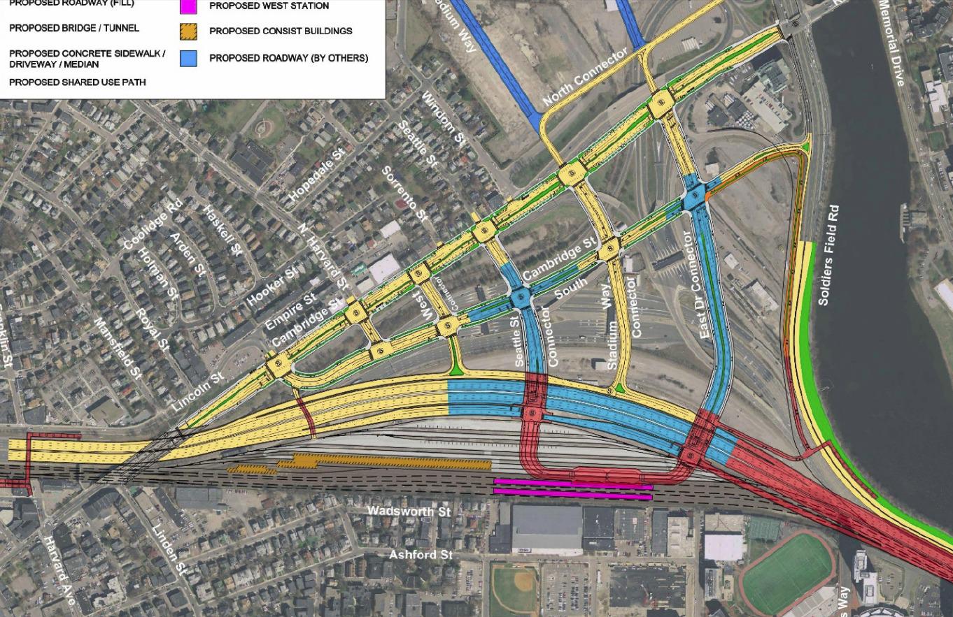
But it seems that potential is being squandered. Despite months of community engagement and a professed commitment to "multi-modal thinking", the design team went off for the winter and nothing came out until finally this June meeting was announced with this plan shown, that seems to have more space allocated to roadway than non-roadway:
In the past year, the DOT design team told us often that they "don't do city planning" and it appears that they don't intend anyone else to do so either. It's hard to imagine anything neighborly fitting between those massive connectors (that will rise on earthen berms above grade, by the way). West Station is included, but can you imagine making the connection to or through that while walking precariously on a pathway above 10-12 lanes of roaring highway and some number of railyard tracks? This design is a highway design, engineered for the comfort of drivers first, and everyone else second. Yes, it's an improvement over the old ways, in that it will all satisfy accessibility regulations, and there are connected sidewalks and protected bike lanes. But with this car-first design, it seems that those facilities will only be used by necessity, not by choice.
We have often been told that "the computer models" require this many lanes, or that size an intersection, etc. The models, of course, have been programmed by engineers to try and predict the future. They say that they can tell us what the behavior of people in the year 2035 will be, with precision. They will tell us that unless they build all of this road space, we will be threatened by some kind of 'traffic armageddon'. It's a bullying tactic, plain and simple. Common sense should tell anyone that trying to predict the future is impossible, much less making precise predictions about conditions on a particular road 20 years from now. The models that they create are nothing but a set of equations and parameters chosen by the people who designed it. These models are as fallible as the people behind them, and can be used to say anything at all. Usually, they are used to say whatever it is the people who hired the modelers want them to say.
In this case, the powerful have spoken, and they have said that they want more automobile capacity in our neighborhood, at our expense. Whenever you hear an engineer say "the models predict increased traffic by X" what you should translate that to is "automobile interests want increased capacity by X, and nothing else matters."
Let's contrast this situation with what it might be like if MassDOT took the other side and tried to help provide space for a new neighborhood with good connections to the surroundings. Then the street network would be laid out at a human scale, with smaller blocks, smaller streets, and a collaboration with city planners in Boston. When it came time to talk about automobile capacity, instead of sending us an ultimatum that "we must tolerate a massive additional influx of vehicles or else", they would calculate the maximum capacity that is compatible with the city planning goals, and work to keep demand for the highway under that level. For example, perhaps it could be considered that commuter bus or train tickets should not be more expensive than paying the toll on the highway. Or that all employers that offer parking benefits must also offer 'parking cash-out' as a benefit for people who chose not to drive.
The reason that this way of working is so tough for them to do, politically, is because it requires that they go to the powerful automobile-promoting interests and tell them: there is a limit, and beyond that, demand for the road is going to have to be managed somehow. An ever-increasing level of traffic on the Mass Pike is not an inevitability. That will only happen so long as more capacity is forced on us, so long as officials are too timid to use the tools of transportation demand management to control the problem at its source, and so long as might makes the right-of-way.
Tuesday, January 20, 2015
False pretexts: motorists only pretend to care about ambulances when doing so happens to be convenient
Two bits of news hit recently that may seem unrelated, at first: Lawmakers seek crackdown on highway protests:
Rep. Colleen Garry, a Democrat from Dracut, proposed making it a felony to block highways. She told the Lowell Sun she was furious about the Thursday morning protests that blocked two sections of the heavily traveled highway through Boston, one north of the city and one south.
"I'm just outraged that people would be that reckless," Garry said. "Everyone has a right to protest, but to do that kind of thing in a highway or a roadway?" [...]
Nearly 30 protesters were arrested and arraigned on charges including trespassing, disorderly conduct, resisting arrest and willfully obstructing an emergency vehicle.
State police said an ambulance transporting a seriously injured car crash victim to a Boston hospital was forced to divert to a hospital outside the city that did not have a trauma unit. The man survived.
State Sen. Richard Ross, a Wrentham Republican, filed legislation that would impose a minimum $5,000 fine and allow a jail sentence of up to six months for willfully trespassing on state highways. Current law allows for a maximum $50 fine and a jail term of no more than three months.And the same week, State to propose opening S. Boston Bypass Road to all drivers:
State transportation officials will file a notice in February with Massachusetts environmental regulators to allow cars coming into South Boston to use the Bypass Road, which is currently restricted to trucks and other commercial vehicles. The pilot program would last six months and could begin as soon as March. [...]
The 1.1-mile road was built to accommodate trucks during the construction of the Central Artery, and when the tunnels were done, the road remained restricted. But as traffic becomes heavier in the fast-growing Seaport District, there has been pressure to open up the road to everyone. [...]
As part of its filing, the state will also propose letting all drivers use the high-occupancy vehicle lanes outside of South Station and the South End.These two pieces of news are, in fact, related: because together they illustrate the hypocrisy and insincerity of our Commonwealth's transportation policy with regard to emergency vehicles. If our elected officials truly cared about emergency vehicle response time -- which they should -- then they would put a quick end to this proposal that will destroy the efficacy of both the South Boston Bypass Road as well as the HOV lanes outside of the South End. If not, then it is quite clear that these politicians, Rick Ross and Colleen Garry, are merely posturing and mouthing platitudes, all while silently sticking it to emergency responders. By far the most common obstacle for emergency vehicles on our roads is not protesters: on a daily basis, emergency vehicles are obstructed by other motorists and the traffic jams created by motor vehicles.

First, a little background: it is quite common for ordinary motorists to believe that the exact same facilities that enable their own travel at high speeds are also beneficial to emergency vehicles. A related objection to certain traffic-calming measures is that they will slow emergency response. However, in reality, the truth is much more complex and requires context-specific analysis. More car capacity might help emergency vehicle response time, under some circumstances. In other scenarios, additional car capacity might harm emergency vehicle response time. An additional, open, free-flowing lane can help emergency vehicles -- but if that same lane jams up with private automobiles then that lane just becomes an obstacle: an overall detriment to response times. In that scenario, removal of a jammed travel lane -- a reduction in car capacity -- can give emergency vehicles the maneuvering room they need in order to avoid the obstacle created by other motorists.
 |
| BU Bridge under renovation (source) |
But none of those safety issues were important to motorists such as Stanley Spiegel, who was quoted in the Boston Globe, in February of 2009, making this threat:
"There's going to be road rage," predicted Stanley Spiegel, who lives across the bridge in Brookline. "If you're going to spend public money to go for an improvement, you don't predictably make things worse.This kind of attitude shows zero concern for the safety of anyone else, but it is sadly all too common among entitled motorists of Mr. Spiegel's ilk. Whenever safety or emergency response goals conflict with increased car capacity, we can see quite clearly where motorists like him stand. Thankfully, in the case of the BU Bridge thus far, MassDOT has not capitulated to the bullies who would remove the shoulder space and turn it back into a fourth congested travel lane.
 |
| The South Boston Bypass Road (source) |
For a number of years, pundits such as Shirley Leung have been campaigning to allow private cars on it. She has quoted old-school 'highwaymen', such as Frank DePaola (who coincidentally is the interim Secretary of Transportation right now), with statements like this: "If you have traffic, and you want to relieve it, you have to find road capacity." As a result of this kind of short-sighted thinking, the South Boston Bypass Road will be jammed up with private cars and will not be able to serve its former purposes any longer. And it goes to show, that when the political push comes to shove, concerns about emergency vehicles suddenly disappear, in favor of a temporary band-aid covering up much deeper, systemic problems with South Boston transportation.
HOV lanes are also a popular target of attack by privileged motorists. It's so common that it's even got a name: the "Empty Lanes Attack", so called because drivers will often claim that the HOV lanes are "mostly empty" or not being used, and therefore should be given over to single-occupancy vehicles. What they (intentionally) fail to realize is that the relative emptiness is what gives the HOV lane its value: it is passable. If it were congested, then it would not be useful. Too bad, then, that even our Boston MPO doesn't seem to understand that most basic of concepts. And because such lanes are designed not to be congested, they are also useful for emergency vehicles that need to bypass major traffic congestion. Thus, the proposal to 'open' the HOV lanes outside of South Station to general traffic will result in degradation of emergency response times.
Where is the outrage? Why, of course there is none: because motorists only pretend to care about ambulances when doing so happens to be convenient. The "Empty Lanes Attack" trumps their false concern about emergency vehicles: the allure of additional single-occupancy vehicle road capacity takes precedence over safety principles.

If officials really cared about emergency response times, then I-93 would have full-width shoulders and/or HOV facilities/zipper lanes extended all the way from end-to-end: taking existing lane space where necessary. It's the only responsible way. But, in fact, the current configuration of the highway that excludes such safety features from much of its length, especially where most constrained. This shows where the true priorities lie: always pushing for 8 lanes of general travel no matter what the consequences are to emergency vehicles or highway safety. Convenience for drivers of single-occupancy vehicles is more important than safety, to our decision-makers.
The fact is that it's easy for officials to claim that they care about emergency vehicle response times when doing so also means more capacity for drivers. But real courage would be shown by officials who show that they care about emergency response even when it's not politically convenient to do so. That means support for restricted lanes such as HOV or bus lanes. That means supporting safety features within the existing right-of-way of roads, without requiring costly expansion. And that means not playing these insincere political games in which 'concern' for safety only arises when it is useful for pursuing another agenda; when that same 'concern' suddenly vanishes the moment it is no longer useful.
Sunday, November 2, 2014
Induced demand is a real problem and it makes congestion relief nearly impossible
For some reason, contrarian articles on "induced demand" seem to be the topic du jour. While they are right to point out that induced demand is a more subtle and nuanced concept than the way it is sometimes popularly handled, both articles seem to err too far in the other direction. Induced demand is a real problem, even if some people sometimes misuse it when making arguments.
Reliability, frequency, and speed
I want to take a quick detour to talk about goals in transportation investment. People tend to make decisions about transportation based on many factors, which I will boil down into three: reliability, frequency, and speed. Reliability encompasses factors such as predictability of trip time, probability of vehicle breakdown, and in general, the ability to make a confident statement about your location at a future time. Frequency is a metric of opportunity: the number of chances that will you have to undertake your trip in the window of time that you have available. And speed is the cost of the trip in time. To be sure, there is some crossover: frequency affects average speed and predictability, for instance. But let's roll with this for now.
There are two major categories: scheduled transportation and unscheduled transportation. Scheduled transportation is largely mass transit, whether public or private. Unscheduled transportation includes modes such as walking, biking and most driving. Frequency is obviously a huge deal for transit; there is also a frequency limitation on unscheduled transportation caused by things like traffic signals, but it is usually small enough to go without notice.
For many people, reliability is the most important characteristic. Walking and biking tend to have the most reliability because they are the least complex modes. Transit with a dedicated right-of-way is also supposed to be highly reliable: a properly run railroad should operate like clockwork (the MBTA on the other hand...). Modes such as driving are very susceptible to being caught in unpredictable and chaotic traffic congestion because they are highly inefficient in terms of space. Cars are also complex pieces of machinery that can easily break down. And mixed-traffic transit gets the worst of it because it has to contend with traffic congestion as well as passenger loading.
Speed should be broken down into average and top speed. Walking is obviously the slowest in average and top speed. Biking does not have high top speed (for most people) but can often maintain decent average speed comparable to a local city bus or a slow train. Transit can vary depending upon quality of right-of-way and maintenance. Driving is usually the mode with highest top speed but in typical traffic conditions can have significantly slower average speeds; possibly even slower than transit or biking.
The speed and reliability of walking is almost always independent of the number of people walking, except in the extreme cases (important as they are). Biking is also mostly able to enjoy that same feature. Transit in a dedicated right-of-way has the capability of operating reliably independent of the number of people attempting to ride it -- up to a point. Once the number of people reaches a certain "crush" capacity then dwell times can be impacted if the operator takes no further action. Finally, driving and mixed-traffic transit are most clearly the modes that are bothered the most by other vehicles on the road. As a driver, or as a mixed-traffic transit rider, the reliability and speed of your trip is highly dependent upon the decisions made by thousands of other people.
Perception and reality don't always match. For example, many people perceive to be in "more control" when driving. But in fact, they're highly dependent on the behavior of other people. Another: many transit riders don't perceive slowness because they are absorbed in some other activity such as reading or working; whereas drivers traveling at the same average speed might be seething and pounding the steering wheel in frustration. And of course: "There is a very strong element of psychology behind traffic patterns."
So, when considering a transportation investment, there are multiple ways to increase capacity. But they do not all have the same effect, even when viewed in such an abstract fashion.
Induced demand
Halloween just passed, so let's talk about candy. Prior to Halloween, there is a high, and one might say inelastic, demand for candy. Many people want to buy candy for Halloween, almost no matter what. This usually shows up in stores as an increase in both supply and prices. Luckily for kids (and the young at heart), supply of candy is relatively easy to increase.
Post-Halloween, the demand drops off. People remember why they don't binge on candy, or let their kids do so, all year. Excess supply is sold off as prices drop in response to the lower, much more elastic, demand. Then the market returns to normal, at least, until the next spike in demand.
Normally, I don't eat much candy. I try to avoid too much sugar for health and personal reasons. And I don't want to spend money on something like that. I could easily go for weeks and months without having a piece of candy. But if you put a bowl of chocolates in front of me, I'll probably take one sooner or later. The low price and ready supply has literally induced my demand. But not every type of candy will have this effect. I'm mostly not a fan of hard candy and will probably just ignore it. And perhaps I've generated economic activity by consuming a piece of chocolate, but I may also be ruining my diet and harming my health.
You probably guessed where I'm going with this. One major difference between candy and transportation is that the supply of the latter is much, much harder to increase. With transportation, very large, very expensive fixed investments are usually expected to accommodate all fluctuations in demand over time. Furthermore, in the United States, people generally do not expect the nominal monetary cost of everyday transportation to vary based on supply and demand, even though prices regularly change for commodities such as candy, food and other items. Instead, the cost fluctuation of everyday transportation is usually expressed as traffic congestion or overcrowding.
When a transportation investment is made, it can both increase the supply and possibly lower the overall cost of travel (either perceived or real) in that corridor. And the way that travel patterns change is hard to predict, despite many efforts.
Former Bostonian, and now Los Angeles transportation blogger VamonosLA writes:
In a large city, there’s almost always going to be trips that people want to make but don’t because of large travel times. This is especially true in large US cities, where we underprice road capacity to the point that new lanes are almost always quickly filled. We misinterpret the construction of the new lane as having caused the demand, but it was there all along.
This is true but is only part of the story. To be sure, some trips generated do represent increased economic activity. Other trips might represent less efficient usage of the now-cheaper resource. For example, you might make multiple trips where one would have sufficed in the past. Or, it might be due to drivers who were enticed into giving up existing car-pools, or who ditched transit. They might even have switched from walking or biking in cases where the distances were feasible (perhaps not in LA).
For a rather stark example, suppose you live in a neighborhood with sidewalks and you are able to walk for many trips. Suddenly, the DOT decides to "improve transportation" by taking away your sidewalks and replacing them with additional car travel lanes. Most people would then choose to stop walking and start driving everywhere. Nowadays it seems unimaginable that such a thing would happen, but it has in the past, and continues to a lesser extreme: oftentimes it is not that sidewalks are removed entirely, but rather, walking is made more unpleasant for the benefit of motor vehicle traffic.
An unknown contributor to the Transportationist named JW writes:
I hate the term “Induced Demand”. I hate the idea that induced demand is something bad; something to be avoided.
[...] From the individual’s point of view, access provides opportunities to more jobs, more entertainment and social options, and more alternatives for consumption of goods and services. From a business’ point of view, access provides a larger pool of labor and more raw materials. From a retailer’s point of view, access provides a larger pool of consumers. From a municipal government’s point of view, access allows more efficient provision of police protection, fire protection and ambulance service by reducing the number of facilities necessary for a given response time.
[...] Transportation improvements that provide greater access per unit of time lower transaction costs. Lower transaction cost lead to great efficiency in the economy and a higher standard of living.
Although JW is careful to couch it in terms of access, which is a good thing, this otherwise sounds like an argument that could be lifted straight out of a 1950s highway builder's manual: new highways lead to greater efficiency and higher standard of living! According to this logic, the congestion on the new highway facilities justifies the construction of even more highways. Clearly something is broken in this reasoning.
The mistake that JW is making is that not all transportation improvements are equal, and that there are more considerations than just raw "access per unit of time", which itself is a difficult thing to measure in practice. For one thing, the increase in access by one mode (say, private car) can lead to the degradation in access by another mode (such as walking, or emergency vehicles). For another, some modes lead to far more pollution and other bad side effects like poor urban planning decisions (e.g. minimum parking requirements, urban renewal, pro-sprawl zoning laws, etc).
Congestion relief
But I think that by far the biggest confusion stemming from the debate around induced demand comes because people are often talking about different things. When highway builders are trying to sell expansion, and when the general public is getting excited about it, they often refer to "congestion relief" as the major feature of the proposal. But what is "congestion relief?" Is congestion relief equivalent to the fact that more people can travel more miles by car? Is congestion relief the possibly increased economic activity and higher standard of living that JW talks about? Is congestion relief the fulfillment of "latent demand" as described by VamonosLA?
I would argue that congestion relief is none of those things in the popular understanding of the term. Instead, congestion relief is generally understood to be an increase in reliability of travel and a subjective decrease in the frustration that each individual has when using the transportation facility. Highway builders sell highway expansion to a public that is hungry for predictable travel times and less stress behind the wheel. However, that sort of congestion relief is largely a false hope, precisely because of the phenomenon that has come to be known as induced demand. It doesn't matter whether that comes from latent demand, or even that it might represent increased economic activity: if the typical driver still experiences large variance in travel times, and high levels of stress, then the congestion relief was a mirage as far as he or she is concerned.
Even the level of spending associated with projects like the Big Dig did not make it immune from this effect. From the Globe:
A Globe analysis of state highway data documents what many motorists have come to realize since the new Central Artery tunnels were completed: While the Big Dig achieved its goal of freeing up highway traffic downtown, the bottlenecks were only pushed outward, as more drivers jockey for the limited space on the major commuting routes.The new tunnels may have been able to handle the flow coming into them, but those outer links themselves were not able to live up to the induced demand.
Ultimately, many motorists going to and from the suburbs at peak rush hours are spending more time stuck in traffic, not less. The phenomenon is a result of a surge in drivers crowding onto highways - an ironic byproduct of the Big Dig's success in clearing away downtown traffic jams.
[...] The findings also call into question the promises made when ground was broken in 1992. At the time, state officials said in a promotional mass mailing to the public that, when it was all done, "people will find the commute to their jobs faster and easier than ever."
Conclusion
So what can be done about congestion, then? It has rightly been pointed out that transit improvement and biking facilities do not "reduce congestion" in this sense. Actually that point should be clarified further: those improvements do not "reduce congestion" when the travel demand is virtually inexhaustible. However, it is possible that in some cases demand is actually exhaustible: for example travel along Comm Ave in Allston, in which case those kinds of improvements can be very effective at real congestion relief. But for destinations such as downtown Boston, there will almost always be another driver willing to replace a trip that is mode-switched away from private vehicle.
All that does not make transit, walking and biking improvements worthless. Jarrett has discussed several reasons why transit is still very worthwhile even without "congestion reduction" and I won't reiterate, but I will add that dedicated-lane transit, walking and biking facilities all increase the supply of "reliable transportation" that boosts accessibility without the harmful side effects imposed by increased car travel. Walking and biking also have great implications for the health of urban neighborhoods and are worthwhile goals on their own.
The idea behind congestion relief is to try and make personal motor vehicles as reliable as walking, biking, or riding a well-run railroad. There are only two known ways to make that actually happen: (a) rigorous scheduling, or (b) decongestion pricing. Railroads avoid congestion and conflict by imposing very strict discipline and heavily analyzed schedules on the movement of trains. To try and apply that same discipline to private cars on roads is politically and practically unfeasible. Therefore that leaves decongestion pricing as the only known way to make private motor vehicle travel reliable, and it works by allowing the price of travel to vary based upon the supply and demand for travel. This is, of course, standard procedure for allocating just about every other resource in our society, but for some reason is completely ignored when it comes to roads. In any case, this article is about induced demand and I have already gone on too long, so I will leave discussion of pricing to others.
Saturday, January 18, 2014
Walk audit of Union Square, Allston and suggestions for the future
 |
| Union Square, Allston. The view from the Twin Donuts shop, facing east. |
(Updates in bold posted 12th November 2015).
Let's take a look at Union Square in Allston, a vibrant neighborhood of the city of Boston. This is the convergence of several busy streets, a transit hub for buses, a retail district, with an elementary school and plenty of nearby residents living within a few minutes walk. I will call this a kind of "audit" because it is based on my observations, as an outsider. The audit uses timings from a weekend study. The main difference between a weekend and a weekday here is length of the full cycle: 90 seconds on the weekend, 110 on the weekday. Adjust accordingly.
 |
| Union Square, landmarks and street names. All satellite imagery courtesy Google. Click on it for larger view. |
- The "level of service" given to the Union Square intersection, by the New Balance transportation study, is "D" (35s to 55s average delay/vehicle) during weekday a.m. peak and "E" (55s to 80s delay/vehicle) during p.m. peak and Saturday peak. "D" is considered normal in cities.
- Traffic levels have declined by about 5-6% here since 2002.
- An examination of the signal schematic (below) shows that for cars, no direction of travel has to wait more than 72 seconds to be given a green phase, on a weekend.
- Yet, the minimum time for a pedestrian to cross Union Square (north/south), legally, is about 100 seconds, if you happen to arrive at the intersection at the optimal moment in the cycle.
- For the less lucky, the expected crossing time is about 145 seconds with a worst case of about 190 seconds.
- For the less capable walkers, the worst case is about 258 seconds. If you happen to be elderly, or a young child. the city expects you to wait 4.3 minutes to cross 95 feet. That's a rate of 0.25 mph.
- The green right turn arrow given to traffic moving eastbound from Cambridge Street is in direct conflict with a walk signal for people crossing between the school and the fire dept station (see picture below).
- The 21 seconds of walk phase given to the 110' crosswalk of Cambridge Street between the Jackson Mann school and Twin Donuts is not enough time for a healthy adult, much less a person with disabilities or a child going to the school.
- There is no crosswalk marked at the Hano Street bus stop, despite heavy ridership. Instead, the city put up a new sign telling pedestrians not to cross there, in response to a tragic crash.
- In the long-term, a Poynton-style redesign should be seriously considered, with a shared space design such as a single-lane roundabout (or similar) completely replacing the traffic signal-controlled intersection. All users of the intersection would benefit, as would the surrounding neighborhood.
Sunday, October 20, 2013
Conservative traffic studies are radical, part 2
Last year I wrote an article entitled "Conservative traffic studies are radical" about the New Balance project traffic study that presumed, as usual, an increase in traffic volume of 0.5 percent per year. I pointed out that this assumption was untrue for the past ten years, using data from MassDOT. At a public meeting, I was able to confirm this data with the consultant that was hired to do the study. But he labeled the 0.5 percent per year assumption as a "conservative" one.
I believe it is disingenuous to call this a conservative estimate because the implications are radical. These kinds of predictions can be used as a weapon to justify deadly street widenings at the expense of the neighborhood. Historically, many widenings were brought about due to fear of increased traffic. Of course, we know that wider roads may induce additional traffic, so no problems were typically solved this way, and the result was usually more dangerous to pedestrians.
With this in mind, as I was reading through the Hotel Commonwealth expansion project PNF, I noticed this very interesting table and quote:
I believe it is disingenuous to call this a conservative estimate because the implications are radical. These kinds of predictions can be used as a weapon to justify deadly street widenings at the expense of the neighborhood. Historically, many widenings were brought about due to fear of increased traffic. Of course, we know that wider roads may induce additional traffic, so no problems were typically solved this way, and the result was usually more dangerous to pedestrians.
With this in mind, as I was reading through the Hotel Commonwealth expansion project PNF, I noticed this very interesting table and quote:

As shown in [Table 2-4], traffic at the specific stations has decreased within the given timeframe. In order to remain conservative, this study assumed a traffic volume increase of 0.5 percent per year.I suppose that this represents progress, in a small way. In the past, I had to push for the project consultant to admit, in person, that traffic volumes were actually declining. Here, it is written in print. However, the evidence presented has not stopped them from making the strange leap to the usual assumption: "0.5 percent per year."
I find this to be a very strange definition of "conservative." Shouldn't that mean expecting an existing trend to continue? If traffic volumes are declining in recent years, then might they not continue to decline? Especially since we know that traffic volumes are largely a function of provided roadway space. Instead, it seems that traffic "experts" have redefined the term "conservative" to mean "does the exact opposite from the trend."
Well, all I can say is: they wouldn't be the first people to redefine "conservative" to mean something much more radical.
Friday, March 15, 2013
"There is a very strong element of psychology behind traffic patterns."
I checked back in on the so-called "Carmageddon" of late 2012 -- the closure of one lane of the Alexander Hamilton Bridge from Manhattan to the Bronx -- to see how it panned out. From the Bergen Record, Warnings staved off traffic gridlock from George Washington Bridge. Quote (italics added):
It was supposed to be a traffic nightmare. It turned out to be a dream.
Predictions of five-mile backups and unprecedented delays on the New Jersey side of the George Washington Bridge appear to have scared thousands of daily commuters away from the span. Except for the recent congestion caused by superstorm Sandy’s assault on the region’s transit system, motorists have seen faster-than-normal rush-hour commutes ever since the July start of a major construction project in New York City, according to transportation officials, experts and traffic data.
“We see this time and time again,” said Jim Bak, director of community relations at INRIX, a company that collects data on traffic along the Interstate 95 corridor and other highways throughout the country. “There is a very strong element of psychology behind traffic patterns.”
In the last few years, he said, similar worst-case warnings in Los Angeles, Seattle and London have had the same effect — actually reducing traffic to below-normal levels on roads that were expected to be clogged. It’s a public relations strategy that state transportation officials in New York, who aired the predictions in media outlets throughout the region before the July 15 start of the project, acknowledge opens them to “cry wolf” criticism. But they say there was no effort to mislead the public and that the backups might have matched predictions if people hadn’t changed their routines.They called it "crying wolf," I called it "Henny Penny." Same difference. More:
At 8 a.m. on a typical weekday, it takes 11 to 13 minutes on average for a vehicle to travel eastbound from the intersection of Routes 80 and 95 in Hackensack to the deck of the George Washington Bridge, according to INRIX. But in the months from the start of the Alexander Hamilton Bridge project until Sandy struck, that drive took an average of between four and six minutes.I'll note that while the original over-hyped, alarmist coverage of the closure was widespread, the follow-up report was buried and barely noticed.
There were nearly 6,400 fewer daily Manhattan-bound trips on average in the 2.5 months after the July 15 start of construction, compared with the period in 2011, according to officials at the Port Authority of New York and New Jersey, the agency that operates the GWB. They also said the warnings appeared to be the cause.
The Lincoln and Holland tunnels, the Port Authority’s other Hudson River crossings, meanwhile, saw no appreciable increase in traffic over that time, said Steve Coleman, a spokes¬man at agency.
Obviously this fits well with their public relations strategy if they are intentionally raising the alarm in an effort to manipulate traffic patterns. It wouldn't do for the public to grow wise to their scheme, would it?
 |
| The Casey Overpass (source) |
But as a result, the public still believes in doomsday predictions when it comes time to discuss the closure of collapsing highways and outdated overpasses. Cries of "gridlock!" and "nightmare!" fly at public meetings. Local residents form a sort of "Stockholm Syndrome" attachment to the 1950s era infrastructure which mutilated their community. There's a great fear of bringing the roadways back to human scale because the supposedly trustworthy officials have spent so many years scaring the public with outlandish claims of impending disaster.
At other meetings, folks stand up and protest against new development -- housing that is so desperately needed, commercial space to attract more jobs -- because they were told it would "worsen congestion." The consultants are stifled by their very own ridiculously oversimplified "level of service" metric which labels intersections with "A" to "F" letter grades. The residents want to know why the wonks aren't doing their homework well enough: surely they could get a better grade if only they put in the effort?
In both cases, we need more honesty from traffic engineers and city officials in charge of transportation. The first step is to make it clear that "Traffic is NOT like water." There is no "strong element of psychology" dictating how water flows, so that analogy simply breaks down. The honesty starts when traffic engineers stand up and admit that motorists adapt to real world conditions, that there are complicated feedback processes which are extremely difficult to model, and that it is not an exact science.
 |
| The use of "level of service." Credit: Andy Singer (source) |
Traffic engineers need to admit that the letter grades given out by "level of service" are extremely misleading. What the grades really measure is the volume of cars using the roads and intersections, not the amount of "work" that an engineer does. They can tinker around the margins but the core cause of an "F" grade is that there are too many cars trying to get through that space. There is only one way to accommodate all those cars: increase the number of lanes. This is how "level of service" was often used in the past: to justify the widening of roads, the creation of grade separations, and the destruction of the communities around them. In many cases, the road widening induced even more demand than before, leaving the area just as congested and more miserable than ever.
Since road widening is no longer acceptable in urban communities, there is only one other choice available: to manage demand. Instead of holding communities hostage to dictated traffic projections, often based on false premises, the communities need to turn that around and stake out what street design is acceptable and what is not. Then the traffic engineers come in as public servants, not masters, and make the safest, best use of the allotted space. Streets are supposed to connect communities, not divide them.

Demand management goes further than that. Unintentionally, the officials in New York have demonstrated a certain principle: If you increase the perceived cost of a particular route, then traffic will decrease on that route. In the case of the Alexander Hamilton Bridge closure, the officials went out of their way to scare people into thinking that there would be an increased "time cost" for going over the George Washington Bridge. It worked. But we don't need to create crises to manage demand. There's a natural way to do it, the same way we manage demand in nearly all other contexts: putting a price to valuable road space. It's been demonstrated to work well in London, Stockholm, and Singapore, as well as other places. And it's the only real solution to congestion.
There's other tools in the demand management box: designing streets so that people feel comfortable walking or biking instead of getting into a car; improving public transportation; building communities where distances are at human-scale instead of at automobile-scale; and reducing the number of parking spaces. These strategies don't directly attack congestion the way road pricing does -- and may not appear to reduce congestion at all. But they do enable more people to live and get around without struggling constantly against congestion.
It is generally not possible to "solve congestion" non-destructively without demand management, in an urban environment. The reason is simple geometry. In a city, most any destination of significance will attract more people than roadways could handle if they all came in cars. There just isn't enough space. The cars that do attempt to come will quickly fill up the available space, and people will call it congestion. It will be congested if few people walk there, and it could still be congested even if most people walk there. Because as long as the demand exists, available slots will be filled with cars, no matter how well the roadways are designed.
 |
| The geometry problem, illustrated (source) |
But that can only go so far. Real action has to be taken at a larger level; maybe community-wide, maybe city-wide, maybe even region-wide. This is because the key factors driving road demand are coming from those levels. For example, zoning rules which dictate "minimum parking requirements" cause traffic to increase in the vicinity of new developments. Zoning rules which force communities to sprawl cause people to use their cars more. Zoning rules which make for miserable streets discourage walking. The construction or widening of a nearby highway induces additional demand on the roads leading to that highway. The deterioration of public transportation forces people to resort to automobiles. And the implementation of road pricing will have to come about through action by elected officials and activism by local advocates.
The first step is honesty from the experts and the transportation officials serving us. The answers are not easy. Many won't want to hear them. But we should demand them.
Thursday, March 14, 2013
Boston MPO memo fails to understand purpose of HOV lanes
The preferential lanes envisioned in this study would usually constitute specialized, separate lanes, generally constructed in the median of an expressway. The adjacent main travel lanes could continue to accommodate their full lane capacities, up to around 2,200 vehicles per hour, depending on the design standards of the roadway. With preferential lane eligibility set to allow fewer vehicles, perhaps 1,500 per hour, buses and other users of the preferential lane would be able to travel at posted speeds. Depending on traffic conditions, users of the general-purpose lanes would continue to experience delays either as a result of heavy traffic or from queues forming at bottlenecks.
It is sometimes suggested that an HOV lane could be implemented by converting a general-purpose lane for the exclusive use of HOVs. Since it is assumed that any preferential lane eligibility rules would result in fewer vehicles in the preferential lane than in the general-purpose lanes, the result would be a reduction in total expressway capacity. Reducing the capacity of a congested expressway would seriously worsen congestion and queuing within and leading to the capacity-reduced corridor, as well as on nearby surface roadways.Here's the author's reasoning:
- General purpose lanes have a capacity of 2,200 vehicles per hour
- HOV/preferential lanes should be limited to 1,500 vehicles per hour
- 1,500 is less than 2,200
- Therefore, general-purpose lanes should never be converted to HOV lanes.
Monday, March 11, 2013
Guest Street and the 64 bus
 | |
|
The recently proposed car-free apartment building on North Beacon Street happens to fall within the Guest Street planning area which was re-zoned last year by the BRA and a local group of residents in the production of the Guest Street Planning Study. The main feature of this area is going to be the $500 million investment by New Balance to rebuild their headquarters and create a mixed-use district. The planning study features many forward looking ideas in an attempt to tackle the difficult problem of building a brand-new neighborhood on formerly industrial land. For example, it will permit heights up to 150' and FARs of up to 4.0 in an effort to bring life and vitality to an area devoid of anything currently. Unfortunately there are some problems, which the study readily admits:
Factors that are detrimental to its attractiveness include the area’s relative lack of public transportation access to downtown and the western suburbs, lack of identity and visibility from major streets in the area, access that is less than clear, and a public realm that is lacking.There are two bus lines which can be said to pass through the study area, both of them infrequent and unreliable: the 64 and the 86. However, two key bus routes are nearby, both of them top-5 in ridership: the 57 and the 66. The study says:
Preserve and expand bus service. In order for the Study Area to develop at all, it is imperative that MBTA bus service be improved to provide access to Downtown, the Back Bay, Longwood/Fenway, and Cambridge.But it does not have any specific recommendations, beyond the new commuter rail station which is now slated to be built. There are also New Balance employee shuttles to Harvard and Kenmore, which will be upgraded according to the PNF, but they do not seem likely to be usable by the general public.
The chart at the top of this post shows the permitted heights and FARs for new development in the planning area, overlaid with the public transit infrastructure currently available. The location of the future commuter rail station at Everett Street is also shown. The yellow stipples reaching out from Union Square trace a walking path of approximately one quarter-mile (~400 meters) from the center of the square. The key problem can be easily observed: almost none of the higher density parcels can be reached within a short walk from Union Square. This seems to be the result of an unfortunate compromise which means that the existing transit resources will be furthest from the developments which need them most.
A quarter-mile is a bit of an arbitrary choice but it's a commonly cited rule of thumb when trying to figure out how far people are willing to walk to transit. What's also as important is frequency: the kind of high frequency that the key bus routes 57 and 66 provide will attract people to walk to them for many purposes. But the infrequent (and often unreliable) 64 and 86 buses will probably only be tolerable for rush-hour commuting purposes, if even that. The commuter rail station, while a net benefit, will also only provide infrequent commute-oriented service.
At this point, the question is: will the Guest Street area evolve into a car-dependent insular subdivision, or will it be able to integrate into the city's transit network in a way that reduces demand for automobile travel? In the former vision, the density will come paired with enormous parking garages (in addition to what's already being planned) and will be stifled by the already jammed capacity of North Beacon Street and Union Square. But if good alternative transportation options are supplied, then we can avoid that fate while adding much needed housing and commercial space.
I believe that to achieve good public transportation in the Guest Street area, the 64 bus route will have to be boosted and remade from a meandering coverage route into an efficient ridership-oriented line. The 86 could also stand to see some improvements. And New Balance should consider coordinating their shuttle operations with the MBTA.
Let's take a closer look at the 64 bus as it currently exists:
View in a larger map
The dark blue line is the route of the 64 bus between Oak Square in Brighton and University Park/Central Square/Red Line connection in Cambridge. The bus travels another 2 minutes to Kendall Square at rush hour. In Cambridge there is a one-way pair formed by the Western Avenue and River Street bridges. The translucent blue strips are connecting bus routes. The yellow areas on the map are sites that have been identified for development in the near or long-term future. In Allston/Brighton we have the Guest Street area, the Harvard IMP area, the Beacon Park area, and in Cambridge the K2C2 study area. The nice thing about the 64 is that it can help connect these new developments with access to the existing jobs and activities in Kendall, Central, Union, Oak Square and Allston Village, and an easy link to the Red Line and all that implies.
Nowadays, there is no consistent frequency of the 64 bus, its schedule is largely dictated by the time it takes for the assigned vehicles to complete their roundtrips. At the weekday peak, there are four buses providing approximately 23 minute headways, which reduces to two buses on 30 minute headways off-peak. In practice the headways vary from as little as 15 minutes to as much as 30 minutes during the peak, and can reach 45 minutes off-peak. The weekend service was recently reduced and features hour headways and nearly non-existent service on Sundays. It is the portrait of a bus route in decline, although the ridership is surprisingly resilient in my experience.
If the Guest Street area is going to develop as a real neighborhood instead of an island in a sea of parking lots, then the 64 bus is going to have to change. There is a mutually reinforcing positive relationship that needs to be jump-started: transit oriented development requires good transit, but the cost of providing that good transit needs good development to justify it. The service improvements will probably have to be phased and given a chance to build up ridership. Here's a few suggestions
- The Hobart Park jog needs to go. The route forms an S-shape just north of Oak Square, where the bus suddenly turns away from Faneuil Street and sweeps around Hobart Park and under the Mass Pike. This could be accomplished in two ways, either by turning directly onto Brooks Street from Faneuil Street, or by just staying on Faneuil Street all the way to Market Street, which has the benefit of shortening the trip. This change saves resources, makes the route more sensible, and avoids tiny Hobart Street which is really not well suited to carrying buses.
- A decision needs to be made about the current Guest Street segment, which now serves the Stop-n-Shop supermarket. Either it needs to be eliminated in favor of a pure North Beacon Street trip, or the Guest Street-running portion should be lengthened all the way to Market Street in order to serve the new developments more closely.
- Cambridge may need to reconsider the design of the Central Square bus station, which accommodates the 64 bus. The geometry of that intersection is the reason why the 64 bus must currently divert onto Magazine Street before arriving at Central Square, instead of the more intuitive River Street approach. Increased frequency may require shuffling things around.
- It should be possible to provide consistent 20 minute off-peak headways by adding a single bus to the route. This starts to bring it within the reasonable range for all-day usage, at least for the initial phase.
- If the other suggestions are adopted and the route is shortened, then using the T's current assumptions, it should be possible to provide 15 minute peak headways by adding only two buses to the peak hour fleet. Again, not ideal, but getting better.
- Other ideas could include: a 64A which short-turns at Market Street and heads back to Kendall Square; or, split the route into a coverage-oriented route 64 and a ridership-oriented route 63 (to pick an available number),
View in a larger map
In conclusion, the Guest Street planning study recommendations have a lot of potential to revitalize a lifeless piece of Allston/Brighton. It is unfortunate that the greatest intensity of planned development is far away from the existing transit resources, and perhaps that should be addressed directly in a revision to the study. But regardless of that, there will be a significant amount of new development taking place outside the quarter-mile "walk shed" of existing frequent transit lines. The commuter rail station will help a little bit but it is no substitute for a frequent route. The 64 bus route must see significant upgrades if this area is going to be able to reach its full potential.
Sunday, March 3, 2013
Light rail and traffic
 |
| Streetcars on Brighton Avenue 1940 |
Public transit in dedicated lanes can enable more people to travel despite congestion on the roads. If you want to actually tackle the congestion itself, then as Brad points out, road pricing seems to be the only option that has been proven to work. But I want to get to his last point which is this:
The other point is that mass-transit systems can lessen road traffic, but only if they’re part of a broader shift by a city to move to denser development. Researchers have found that people living in more compact cities with better transit options do drive less overall. But that shift doesn't happen overnight. And not all light-rail systems are even built with this sort of development in mind.Boston happens to be one of those places with "light rail" and denser development built up along those corridors, thanks to the fact that most of it was built before zoning became a weapon used against cities. So if you take a look a Commonwealth Avenue you find something interesting. Despite the fact that the road has 6 lanes of travel (4 inner, 2 outer), MassDOT records very low traffic levels on the order of 12,000 AADT. By comparison, Washington Street in Brighton Center carries 14,500 AADT with only 2 lanes, and Harvard Avenue is all the way up at 18,100 AADT with only 2 lanes as well. Why isn't Commonwealth Avenue more like Brighton Avenue which has 4 lanes and sees volumes of 23,000 to 28,000 AADT?
First, for a variety of reasons, Commonwealth Avenue (in Allston/Brighton) is not a heavily used through-route, unlike Harvard Avenue or even Washington Street, so the traffic on it is largely coming from or going to nearby places. Second, although the development along the avenue is at city levels of density (~80-120 dwelling units/acre), because it grew up around the streetcar, there's not as much parking as such quantities of units would bring under current zoning codes. So trips are much less likely to be made by automobile. This seems borne out by the fact that the current "B" line is the busiest branch (~30,000 boardings/weekday) and that just over 50% of residents who live along this corridor get by without access to a car.
So in congruence with Brad's point, I think that you have here an example of how a century of streetcar service, combined with the long-ago shift to denser development, has lessened road traffic in the present day. Now the question for many developing light rail systems is: can you also achieve that, and perhaps on a shorter timescale?
Thursday, February 21, 2013
Transit signal priority
Following onto my last post about station elimination and consolidation: The topic of transit signal priority comes up frequently when discussing improvements to the Green Line. It was prominently discussed at last month's Green Line meeting. I went and did some background research on it.
Transit signal priority is the application of subtle changes to traffic light timing in order to assist the passage of transit vehicles. Broadly speaking, there are two categories: passive and active. Passive priority is static and predetermined: for example, changes to the timing of traffic light phases, or to the transit schedules. Active signal priority occurs dynamically, triggered as the system detects the approach of a transit vehicle. I will be focusing on active TSP.
TSP should not be confused with "preemption" which is the abrupt interruption of normal traffic signal functioning. Preemption is used for safety purposes primarily: to assist emergency vehicles, or to clear a railroad grade crossing. The key difference is subtlety: traffic signal priority should be almost completely unnoticeable to observers.
Some examples in other countries include: Zürich, Paris, London, Sheffield (UK), Amsterdam, Hannover (Germany), Sapporo and Curitiba (Brazil).

To see that, you must think about a transit route as a loop -- even linear routes must double back and return vehicles to their starting position somehow. Normally, after a vehicle returns to the beginning, it is allowed to rest for a certain period of time called the "layover." The driver gets a break, or changes out. If the vehicle is running late, but not too late, then the layover is shortened in order to "recover" the schedule.
Agencies build substantial "recovery time" into the layover time of a route, usually by tacking on a "padding" percentage of the round trip time. The percentage depends upon the reliability of the route: the goal is to minimize the probability that a vehicle finishes its round trip so late that it has exceeded the layover time allotted. So if TSP makes the route more reliable, then the layover time can be reduced.
 Whether through increased reliability, or reduced round trip time, if the overall time can be reduced by enough, then fewer vehicles and fewer drivers are needed to operate it -- a major cost savings. To give an example: the MBTA Blue Book 2010 reports that in morning rush hour the "B" branch of the Green Line requires 20 trains which are supposed to be spaced at 5 minute headways. This means that trains can leave Boston College over the course of 100 minutes until a returning train must be reused. The Blue Book also states that the scheduled time to reach Government Center is 45 minutes, and the scheduled return time is 43 minutes, for a scheduled round trip time of 88 minutes and a layover of 12 minutes. That implies a 13.6% padding.
Now suppose that the padding could be reduced to 7% which happens to be the Swiss standard. That would imply a 6.2 minute layover, and at 5 minute headways, only 19 trains would be needed to provide morning rush hour service on the Boston College line. The NTD factsheet says that light rail costs $216/vehicle hour to operate here, so removing just that one train from just that one shift saves approximately $120,000 a year.
Even if 7% is considered to be too little padding for other reasons, the combined travel time and layover time savings could easily add up to 5 minutes or more, producing the same operating cost reduction. And applied to all shifts you might even see savings add up to millions of dollars per year which can be put into other operating improvements.
The North American systems studied in-depth by the FTA did not find any significant delay experienced by the non-priority traffic, but systems in the past have failed due to improper planning, so it is important to study the design. However, even if there were significant delay to vehicles, that is not the correct metric to be using. Traffic engineers infamously use "level of service" to grade intersections by vehicle-seconds of delay even though this kind of thinking is notoriously unsuitable for city streets with many different kinds of users. Instead, transportation departments ought to be thinking about optimizing the safe "movement of people" instead of the "movement of vehicles." And in that respect, even if a signal priority system does cause some measurable delay to non-priority vehicles, it needs to be evaluated by the overall effect it has on people, not vehicles.
For example, suppose the installation of TSP at an intersection causes an average of 5 seconds additional delay to 36,000 non-priority vehicles, but also manages to reduce average delay by 15 seconds to the transit vehicles carrying 30,000 people a day. Assuming an occupancy rate of 1.2 persons per car, that's 216,000 person-seconds of delay to non-priority traffic. That sounds pretty significant until you realize that it is massively outweighed by the 450,000 person-seconds saved by the riders. And 36,000 non-priority vehicles is very high; in most cases along the Green Line the number is much, much less.
A transportation department with its priorities straight would consider person-seconds the metric by which to optimize, not vehicle-seconds. And "level of service" is not a valid metric to use on city intersections because it does not make consideration for people, traveling in all modes, with or without vehicles.
What is transit signal priority (TSP)?
 |
| Example phases in a traffic light cycle (simplified) |
TSP should not be confused with "preemption" which is the abrupt interruption of normal traffic signal functioning. Preemption is used for safety purposes primarily: to assist emergency vehicles, or to clear a railroad grade crossing. The key difference is subtlety: traffic signal priority should be almost completely unnoticeable to observers.
Who is using TSP?
In the United States and Canada, over twenty agencies report using TSP, including but not limited to: Los Angeles Metro, Houston MTA, Sacramento RT, Pierce Transit (Tacoma), TriMet (Portland), SEPTA (Philadelphia), PVTA (Springfield, MA) and Calgary Transit.Some examples in other countries include: Zürich, Paris, London, Sheffield (UK), Amsterdam, Hannover (Germany), Sapporo and Curitiba (Brazil).
Why do TSP?
The primary benefit of TSP is enhanced reliability of schedules: better maintenance of headways and less bunching. One of the biggest causes of variability is the unpredictable delay caused by traffic signals, compounded over the course of many intersections. TSP makes it possible to avoid the worst-case delay. A secondary benefit of TSP is a slight reduction in average trip time: less waiting at intersections. Another benefit is a potential reduction in operating costs for the route; saving money or boosting resources elsewhere.
To see that, you must think about a transit route as a loop -- even linear routes must double back and return vehicles to their starting position somehow. Normally, after a vehicle returns to the beginning, it is allowed to rest for a certain period of time called the "layover." The driver gets a break, or changes out. If the vehicle is running late, but not too late, then the layover is shortened in order to "recover" the schedule.
Agencies build substantial "recovery time" into the layover time of a route, usually by tacking on a "padding" percentage of the round trip time. The percentage depends upon the reliability of the route: the goal is to minimize the probability that a vehicle finishes its round trip so late that it has exceeded the layover time allotted. So if TSP makes the route more reliable, then the layover time can be reduced.

Now suppose that the padding could be reduced to 7% which happens to be the Swiss standard. That would imply a 6.2 minute layover, and at 5 minute headways, only 19 trains would be needed to provide morning rush hour service on the Boston College line. The NTD factsheet says that light rail costs $216/vehicle hour to operate here, so removing just that one train from just that one shift saves approximately $120,000 a year.
Even if 7% is considered to be too little padding for other reasons, the combined travel time and layover time savings could easily add up to 5 minutes or more, producing the same operating cost reduction. And applied to all shifts you might even see savings add up to millions of dollars per year which can be put into other operating improvements.
How does TSP work?
There are a few techniques that are generally applied to achieve active signal priority. Any combination of them may be deployed, depending on the conditions at each intersection. Vehicle detection methods must also be selected which are capable of providing enough notice of arrival to the traffic light controller. Such methods can be as simple as an induction loop in the ground, an optical sensor, or even information obtained from GPS satellites used to model the real-time schedule. |
| Green extension keeps the signal green for a short while longer to allow a detected transit vehicle enough time to pass a light that was about to turn red. |
 |
| Early green hastens the expiration of the red light so that the detected transit vehicle can get moving as soon as possible. |
 |
| Phase insertion waits for the next moment in the cycle that all conflicting traffic is stopped and then takes a few seconds for a special "phase" which gives the detected transit vehicle an opportunity to proceed. |
 |
| Phase rotation changes the ordering of interchangeable phases so that the detected transit vehicle can proceed sooner rather than later. The best example is a left-turn-only phase which normally occurs before straight-through traffic goes: it can easily be "rotated" to occur after the straight-through phase instead. |
What are the downsides?
Deployment of TSP should be transparent to the typical road user. Unless they are looking closely, they shouldn't notice anything different; although some techniques are more obtrusive than others. Green extension is probably the least noticeable intervention. On the other hand, early green has to allow enough time to safely clear the intersection: which can be difficult in the case of pedestrians. Phase insertion may be noticed by those waiting for the next phase, but it is a fairly short delay. Phase rotation may confuse those who have memorized the light patterns; but so would any change (Zürich chose to randomize such phases before implementing signal priority, to prepare the public in advance).The North American systems studied in-depth by the FTA did not find any significant delay experienced by the non-priority traffic, but systems in the past have failed due to improper planning, so it is important to study the design. However, even if there were significant delay to vehicles, that is not the correct metric to be using. Traffic engineers infamously use "level of service" to grade intersections by vehicle-seconds of delay even though this kind of thinking is notoriously unsuitable for city streets with many different kinds of users. Instead, transportation departments ought to be thinking about optimizing the safe "movement of people" instead of the "movement of vehicles." And in that respect, even if a signal priority system does cause some measurable delay to non-priority vehicles, it needs to be evaluated by the overall effect it has on people, not vehicles.
For example, suppose the installation of TSP at an intersection causes an average of 5 seconds additional delay to 36,000 non-priority vehicles, but also manages to reduce average delay by 15 seconds to the transit vehicles carrying 30,000 people a day. Assuming an occupancy rate of 1.2 persons per car, that's 216,000 person-seconds of delay to non-priority traffic. That sounds pretty significant until you realize that it is massively outweighed by the 450,000 person-seconds saved by the riders. And 36,000 non-priority vehicles is very high; in most cases along the Green Line the number is much, much less.
A transportation department with its priorities straight would consider person-seconds the metric by which to optimize, not vehicle-seconds. And "level of service" is not a valid metric to use on city intersections because it does not make consideration for people, traveling in all modes, with or without vehicles.
Further reading.
Subscribe to:
Posts (Atom)