It's been a bit over a week since Anita Kurmann was killed in a crash with a turning truck that then drove off without stopping. Few details are available but there are two things that we can be certain about: first that it is a terrible tragedy, and second that little to nothing will be done to prevent such tragedies in the future. There are possible alleviating measures that exist and could be required by proper regulation, including truck side-guards, or restrictions on the size, weight, number of axles, and length of trucks that are allowed on certain city streets. Our public street rights-of-way were laid out long before the concept of a 5-axle, 40 ton, 53-foot long truck was ever conceived. And it is difficult to imagine how a human-friendly environment could ever be compatible with such behemoths.
Although technically receiving more oversight than the personal car, the trucking industry is remarkably regulation-free compared to other transportation sectors. No other form of transportation allows size, weight and maneuverability concerns to be so radically dismissed in the same way. Air traffic control would never allow an oversized jumbo jet to land at a tiny airport. Railroad companies would never tolerate oversized freight cars that slammed into bridge abutments. Yet, for some reason, when it comes to the road, we simply shrug when oversized trucks cause death and destruction on a daily basis. It is curiously ironic that city planners have spent the past century meticulously separating people's homes away from industry, but still continue to design extremely dangerous, high-speed roads carrying heavy industrial truck traffic right next to those very same homes.
When it comes to regulation of motor vehicles, all the furor seems to focus around taxicabs vs Uber, where the regulations have no safety purpose, but are just one piece of a tug-of-war between the few dirty 1970s-style dirtbags who run the taxicab business and the slick B-school douchebags who run Uber. And when it's not about profits, it's about traffic speeds, because the only thing, besides money, that seems matter to people in power is convenience for suburban drivers. Such regulation has nothing to do with safety and everything to do with privileging the powerful. Meanwhile, some drivers manage to keep their license long enough to score four OUI offenses and kill someone. Or even when the police determine that a driver is an "immediate threat" the antiquated system cannot process the paperwork in time to prevent him from killing. Those are some real examples of problems that could be fixed with proper rules, procedures and regulations. I wonder if it will ever happen.
The trouble is, of course, that regulations are not created solely based upon merit in achieving objective goals such as safety. Regulations are a product of politics, a swirling morass of money, culture, personal vendettas, and tribalism. 149 people were killed by motor vehicle crashes in the first 6 months of this year. But no politician is going to be held accountable for that carnage. Few voters even spend much time thinking about it. So the perverse story doesn't change from year to year. I won't pretend to have an answer, but I will note that if the problem is politics, then the solution has to be too.
Showing posts with label planning. Show all posts
Showing posts with label planning. Show all posts
Monday, August 17, 2015

Tuesday, July 28, 2015
The subversion of fair housing law by pernicious zoning ordinances, part 2
[continued from part 1]
Massachusetts has, in the past, attempted to address the problem of snobbish, exclusionary zoning. The section of law known as Chapter 40B was passed in 1969:
The law happened to go into effect not long prior to Boston's school busing crisis, an era that exacerbated the divide between city and suburb, as 'white flight' brought many new residents to the suburban towns, eager to shut the door behind them as they arrived. From Common Ground:
Massachusetts has, in the past, attempted to address the problem of snobbish, exclusionary zoning. The section of law known as Chapter 40B was passed in 1969:
This law was seen as one of the earliest recognitions of the racial and economic segregation often imposed by exclusionary zoning practices such as minimum lot sizes and bans on multi-family housing. The purpose of the law is to “address the shortage of low and moderate income housing in Massachusetts and to reduce regulatory barriers that impede the development of such housing.”
Often referred to as the “Anti-Snob Zoning Law,” the “Comprehensive Permit Law” and the “Massachusetts Affordable Housing Law,” Chapter 40B is seen as a “one-stop” permitting process for developers proposing low and moderate-income housing projects. Rather than applying to many local boards, the developer applies for a “comprehensive permit” to one local authority—the Zoning Board of Appeals (ZBA).
Chapter 40B is significant in that it was one of the first instances in which a state exerted authority over local control in land use zoning.4 Therein also lays its controversy. Under 40B, a developer has the right to appeal to the state Housing Appeals Committee (HAC) if it is denied a comprehensive permit for a qualified project, or if it is granted one with conditions making the project uneconomic. Under 40B, ZBAs are able to approve projects with higher density than current zoning allows, making it more economically feasible to develop affordable housing.Chapter 40B only applies to municipalities that have less than 10% of their housing stock designated as 'affordable', and it does not apply to Boston at all (due to the Boston Redevelopment Authority). It's success has been limited: 48,000 units were created from 1969 through 2008, of which 26,000 were designated as affordable. That's an average of 1,230 units per year, or 666 affordable per year -- far lower than the demand. And only 55 municipalities (of 350) had met the 10% requirement after nearly 40 years of the law.
The law happened to go into effect not long prior to Boston's school busing crisis, an era that exacerbated the divide between city and suburb, as 'white flight' brought many new residents to the suburban towns, eager to shut the door behind them as they arrived. From Common Ground:
Indeed, barely a month after Garrity’s ruling on the constitutional violation, the Supreme Court effectively cut off one possible avenue of remedy. In Milliken v. Bradley, it over-ruled a district court which had required cross-busing between Detroit and its surrounding suburbs. Since the lower court had found de jure segregation only within the city and not in the suburbs, the Supreme Court held that a metropolitan-wide order “would impose on the outlying districts, not shown to have committed any constitutional violation, a wholly impermissible remedy.” Milliken marked an important turning point in the Court’s approach to school segregation. Albeit by the narrowest margin (5–4) in any major school case yet, the Court halted the advance of school desegregation at the city line. Although many students of the matter believed a clear pattern of “state action” could be detected in the suburbs—notably in government housing loans and highway construction policies which operated to keep them predominantly white—the increasingly conservative Court majority declined to push its broadened doctrine of de jure segregation that far.The anti-busing protesters could no longer maintain segregated schools in the city; instead, they moved to the surrounding towns where they could promote segregation through the use of regulatory tools such as zoning codes. The borders of municipalities acted as effectively as segregated neighborhood boundaries had before. Since then, a common complaint of town NIMBYs opposed to residential development is that it might bring 'too many' students to the public school system, thereby 'overwhelming' it. Such 'pseudo-engineering' of the school system by laypeople -- as if they were engineers designing a waterworks -- is more likely to be a cover story for their true motivation: the exclusion of people unlike themselves. And this effect may partially explain why the Chapter 40B requirements have not been met by the majority of towns in the Commonwealth, even after nearly half a century has passed.
Sunday, July 26, 2015
Affordable housing money wasted on pointless parking spaces
Just a quick blog post on something I noticed yesterday. A quote from a letter filed with the BRA regarding a new project on Telford Street:
At the recently constructed Charlesview project across Western Avenue from the Telford Street project site, the fully occupied 240 unit residential development has about 180 spaces of its 248 space parking garage used. Since there is no additional fee for parking above monthly leases at Charlesview, these numbers represent a true parking demand of about 0.74 spaces per unit.Think about how much affordable housing money has been wasted on these luxurious accommodations for automobiles -- which aren't even being utilized.
Sickening.
Thursday, July 23, 2015
The subversion of fair housing law by pernicious zoning ordinances, part 1
I'm not a religious person but I think there is genuine evil in this world. And one of those evils is the persistence of segregation fifty years after the Civil Rights movement of the 1960s.
One of the more important Supreme Court decisions of the year was handed down last month. Texas Department of Housing and Community Affairs v. The Inclusive Communities Project, Inc. ruled that 'disparate-impact' claims are valid under the Fair Housing Act of 1968. This ruling ensures that an important tool in the fair housing toolbox continues to be usable: the notion of 'disparate-impact', or that government policies can have an unstated yet implicit racially-biased effect.
 |
| 2010 Census Block Data showing distribution of population by race in Boston (source) |
The Inclusive Communities Project brought suit over how the Texas Department of Housing and Community Affairs distributes tax credits for low-income housing. The Department’s policy, the group claimed, causes almost all affordable units to be built in racially segregated low-income areas, providing minorities with few opportunities to move to integrated or wealthier areas. Though the creators of the tax credit policy had no racial intent, according to the Inclusive Communities Project the results of the policy confined minorities to segregated areas.From the opinion:
Recognition of disparate-impact claims is consistent with the FHA’s central purpose. See Smith, supra, at 235 (plurality opinion); Griggs, 401 U. S., at 432. The FHA, like Title VII and the ADEA, was enacted to eradicate discriminatory practices within a sector of our Nation’s economy. See 42 U. S. C. §3601 (“It is the policy of the United States to provide, within constitutional limitations, for fair housing throughout the United States”); H. R. Rep., at 15 (explaining the FHA “provides a clear national policy against discrimination in housing”). These unlawful practices include zoning laws and other housing restrictions that function unfairly to exclude minorities from certain neighborhoods without any sufficient justification. Suits targeting such practices reside at the heartland of disparate-impact liability. See, e.g., Huntington, 488 U. S., at 16–18 (invalidating zoning law preventing construction of multifamily rental units); Black Jack, 508 F. 2d, at 1182–1188 (invalidating ordinance prohibiting construction of new multifamily dwellings); Greater New Orleans Fair Housing Action Center v. St. Bernard Parish, 641 F. Supp. 2d 563, 569, 577–578 (ED La. 2009) (invalidating post-Hurricane Katrina ordinance restricting the rental of housing units to only “‘blood relative[s]’” in an area of the city that was 88.3% white and 7.6% black); see also Tr. of Oral Arg. 52–53 (discussing these cases). The availability of disparate-impact liability, furthermore, has allowed private developers to vindicate the FHA’s objectives and to protect their property rights by stopping municipalities from enforcing arbitrary and, in practice, discriminatory ordinances barring the construction of certain types of housing units. See, e.g., Huntington, supra, at 18. Recognition of disparate impact liability under the FHA also plays a role in uncovering discriminatory intent: It permits plaintiffs to counteract unconscious prejudices and disguised animus that escape easy classification as disparate treatment. In this way disparate-impact liability may prevent segregated housing patterns that might otherwise result from covert and illicit stereotyping.
This is an important ruling if and only if the Federal government backs it up by strengthening and enforcing the regulations based on the Fair Housing Act. Unfortunately, over the past four decades, successive administrations including the current one have largely done nothing or acted to undercut the law. That might change now, with the Supreme Court's fresh ruling.
This is significant if it is used to reverse some of the most pernicious and widespread zoning code techniques that effectively cause economic and racial segregation through disparate-impact. Zoning has long been about exclusion, even continuing after explicitly racial zoning was struck down by the courts. From Dead End, a book about the history and effect of sprawl, by Benjamin Ross:
That is not the only type of regulation that is used to make land and housing unaffordable. For example, onerous requirements for front yard, back yard, and side yard ensure that only those people wealthy enough to afford 'conspicuous waste' can live there. Minimum parking quotas force residents to pay for parking spaces whether they use them or not. And, most infamously, the prohibition against apartments or multi-family housing in many zones makes it impossible to divide the cost among several families. Generally, the net effect of these regulations is either implicitly or explicitly intended to lower density. One glance at the population distribution map above should confirm that there is more than a passing correlation between 'low density' and 'overwhelmingly white'. That is disparate-impact at work: it is subtle in the wording of zoning codes, but the net effect over time is clear. The question now is: will the government begin to tackle the inequities created by local zoning codes? And how?
[continued in part 2]This is significant if it is used to reverse some of the most pernicious and widespread zoning code techniques that effectively cause economic and racial segregation through disparate-impact. Zoning has long been about exclusion, even continuing after explicitly racial zoning was struck down by the courts. From Dead End, a book about the history and effect of sprawl, by Benjamin Ross:
[Euclid v Ambler, 1926] moved quickly beyond the specifics of Ambler’s property; from the beginning, the principle of zoning was at stake. And the main principle was the exclusion of people, the people who lived in apartment houses. “In the last analysis,” Judge Westenhaver wrote perceptively in his opinion, “the result to be accomplished is to classify the population and to segregate them according to their income or situation in life.” The Supreme Court saw the issue similarly. The village’s power to keep out factories was not really in doubt, it observed: “The serious question in the case arises over the provisions of the ordinance excluding from residential districts apartment houses, business houses, retail stores and shops, and other like establishments.”And The Racial Origins of Zoning in American Cities:
"What began as a means of improving the blighted physical environment in which people lived and worked," writes Yale Rabin, became "a mechanism for protecting property values and excluding the undesirables." The two interest groups that were regarded as the undesirables were immigrants and African Americans.While instances of explicit racial exclusion through zoning and restrictive covenants are generally overturned by the courts, that has not been the primary mechanism through which segregation is created and maintained. Instead, the racially biased effect is engineered through neutral-seeming zoning codes that provide an aura of plausible deniability. For example, a zoning code might mandate a minimum lot size, such as a quarter-acre, for construction of housing, while forbidding anything larger than a single-family home to be built. None of the language used has any explicit mention of race or class, but the net effect is to restrict residency on that property for only a single family capable of affording a quarter-acre of land. In any reasonably attractive neighborhood, the price of that 10,860 square feet of land is beyond the reach of low- or middle-income families, thus effectively excluding all but the wealthy.
That is not the only type of regulation that is used to make land and housing unaffordable. For example, onerous requirements for front yard, back yard, and side yard ensure that only those people wealthy enough to afford 'conspicuous waste' can live there. Minimum parking quotas force residents to pay for parking spaces whether they use them or not. And, most infamously, the prohibition against apartments or multi-family housing in many zones makes it impossible to divide the cost among several families. Generally, the net effect of these regulations is either implicitly or explicitly intended to lower density. One glance at the population distribution map above should confirm that there is more than a passing correlation between 'low density' and 'overwhelmingly white'. That is disparate-impact at work: it is subtle in the wording of zoning codes, but the net effect over time is clear. The question now is: will the government begin to tackle the inequities created by local zoning codes? And how?
Tuesday, March 10, 2015
The scourge of single-story retail
I'm sifting through some of my pre-snowpocalypse photographs for this post, so we can remember Boston as it once was.
 |
| The Fenway is a densely populated vibrant neighborhood with a strange dichotomy between retail buildings and residential buildings, like many other streetcar suburbs built around the same time. |
 |
| Another example from the Fenway. |
 |
| Double-whammy of bad 20th century planning: surface parking and single-story retail immediately adjacent to major Green Line station in Brighton. |
 |
| Same place, across the street. Typical of Comm Ave, there's a strip of single-story retail adjacent to 5-story or more apartment buildings. Some parts of Comm Ave do have ground-floor retail below residential, but it's the exception, not the rule. |
 |
| Union Square, Allston, with lots of great little shops and restaurants. But almost all of them are in single-story retail buildings. The tall building behind is from the 1980s, and does have a little bit of ground floor retail included, but is separate from most of the shops you see. |
 |
| Single story retail from the early 20th century. But as you can see, it used to be a whole lot better. Nowadays the building is used for storage of automotive supplies, and the intersection is a motor vehicle-dominated nightmare. In 1889, the first electric trolley line in Boston departed from the Allston depot along those tracks. Now, the Allston depot is a pizzeria with a giant surface parking lot. |
 |
| In the mid-1960s this theater was torn down to be replaced by a nearly featureless single-story retail building with surface parking out front. As the zoning regulations of the time would dictate. |
 |
| Single-story retail in the center of Hyde Park's business district. |
 |
| Single-story retail in triple-decker Dorchester, along Blue Hill Ave, where trolleys once roamed, and where frequent buses ply today. |
 |
| Single-story retail and massive surface parking near Forest Hills, a major MBTA subway, bus and commuter rail station. |
 |
| Single-story retail on Comm Ave next to a Green Line station. |
 |
| Tall residential, short retail, MBTA station: Brookline is no exception. |
In a city with an acute housing shortage, where space is at a premium, why do we allow so much waste to take place? It seems like there are hundreds of thousands of people who would like to be able to live in these neighborhoods with decent local shops, and in some cases, places that are only steps away from frequent MBTA service. Multistory buildings with ground floor shops and upstairs residences are not new in Boston -- they were quite commonly built in the 18th and most of the 19th centuries. The oldest neighborhoods in Boston: Beacon Hill, the North End, even the Back Bay, all have streets lined with buildings that have ground floor retail and homes above. Yet, starting around 1890 or so, it seems, some kind of insanity gripped America: suddenly, neighborhoods started being developed with apartment buildings on one block and single-story retail on another. Sometimes even on the same block.
I don't have a definitive answer, but there are several pieces in play:
- The criminally incompetent, so-called "City Planning" movement started around the turn of the 20th century, and these new planners were notoriously blind to the actual sources of city vitality and diversity. In some cases, they were opposed to city life, and actively sought to destroy it. Records from the City Planning Board of Boston show that many early discussions focused around choosing which buildings to destroy in order to widen roads. No doubt, they probably saw mixed uses as being "messy" and falsely perceived them as a source of traffic congestion.
- Property tax laws in this country can be counterproductive: they effectively penalize landowners who invest in their properties. In some cases, building owners may have chosen to cut down floors off their own buildings to save on tax expenses. In a sane world, such crazy outcomes would result in legislative self-examination and reform of the tax laws: for example, by repealing property taxes and replacing them with something less harmful like a land-value tax. In this world, well... no.
- In New England (and NY) it was common to quickly erect buildings that became known as "taxpayers" in order to generate some value quickly for the land without much effort. These taxpayer buildings were just enough to house some retail and then got locked into place when zoning came into effect around the mid-1950s. Many of the featureless boxes plaguing our landscape seem to fall into this category, but there are also plenty of examples of single-story retail with the kind of fine architectural detailing that seems out-of-place on a taxpayer.
- The economics of redevelopment seem to require a significant density boost in order to replace a revenue-generating property with a new one. If floors cannot simply be added to the top of the single-story building, and if the construction requires a shutdown of the business operating within, then the end result of construction has to be much taller than what previously existed. In the case of single-story successful retail, that probably means going up to 4-6 levels.
- And this discussion wouldn't be complete without mentioning the nefarious effect of mid-20th century zoning regulations. It is quite possible that many single-story retail buildings were intended to be temporary. But once zoning kicked in, redevelopment -- already difficult -- became near impossible. The density boost required to make redevelopment financially palatable was now illegal or required expensive variance hearings. In many cases, even the existing property was made illegal by unreasonable zoning requirements that demanded excessive amounts of parking that simply could not be provided in a space-constrained city neighborhood.
So, as a result, we have a bunch of neighborhoods where, if you somehow transported some people from 1915 one hundred years into the future to 2015, they might ask: "Why do you still have all these same crummy, single-story buildings that existed in my time?" ... After, of course, catching up on the past hundred years of history.
If we are serious about tackling the problem of rising housing costs and creating a better, more vibrant city that is accessible to all, then we will need to find a way to deal with these squat, inefficient, single-story structures. I often hear people complain that Boston is space-constrained, that we don't have room for development. That's not really true, as there are too many vacant parcels. But there are also many underutilized parcels in locations that can easily support much more. The replacement of single-story buildings that are located adjacent to frequent transit ought to be a high priority for all of the cities and towns in the region.
Sunday, August 3, 2014
Fifty years of the MBTA: where is the vision?
Yesterday, I was riding the T towards home with a friend who lives nearby me, and I mentioned that I had canceled my monthly pass for the remainder of the summer. The value proposition just isn't there for me anymore. At least, so long as the weather remains decent, I'm not sure I will be able to use up $75 in stored value. He said that he was mulling the same issue, because at $75, it was more of a struggle for him to afford. But then he surprised me: "the fares go up regularly now, but the MBTA has no vision, no plan for improvement, no sense that things are going to get better in the future." This is coming from a person who is just a regular user of the system, not someone who probably spends too much time thinking about urban transportation issues. And, I have to admit that I am forced to agree with him.
Today is the fiftieth anniversary of the formation of the Massachusetts Bay Transportation Authority from the ashes of the Metropolitan Transit Authority, on August 3rd, 1964. The new authority was intended to unify mass transportation operations in the greater Boston area under one umbrella, a much larger scope than the old MTA. And in some aspects, it has been successful, or at least, impactful. The iconic Ⓣ logo, the famous color-coding of rapid transit lines, the death and rebirth of commuter rail, the consolidation of management, the expansion of the Red Line, the controversial Orange Line relocation, and many other things.
The long term vision for the MBTA is called the Program for Mass Transportation (and yes, there is a broken link on their website, and this is where it's supposed to go). If you look through the Progress document, you'll see that most of the accomplishments are things like replacing vehicles, doing maintenance on right-of-way, improving accessibility, etc. I do not want to disparage any of those activities: they are very important for the proper functioning of the system. But they are not the kind of accomplishments that are going to constitute a "visionary step forward" for transportation in the Boston region, as seen by ordinary users. Actually, most of what's listed under progress are fixes that should be taken as a matter-of-course: yes, stations should be accessible, vehicles should be in working order, and tracks in good repair. That goes without saying, really.
But what has actually been accomplished in terms of expanding the "good transit" system in the past fifty years? Much of what was done was proposed, in at least a similar form, on this 1945 map from the old Boston Elevated Railway:
There are some things on this map that are dead letters: such as the configuration of the Red Line past Harvard, which was later designed to curve north towards Davis and Alewife instead of through Watertown. But much of what was accomplished is represented here, in a plan from 1945. Several extensions were built prior to the formation of the MBTA: what we now know as the "D" branch of the Green Line, and what we now know as the Wonderland extension of the Blue Line. After 1964, the MBTA built: the Braintree branch of the Red Line, and the extension of the Orange Line through Malden. They also attempted to build the Red Line to Arlington via a different route than shown, but were blocked by NIMBYs and cut short to Alewife. Since then, most expansion ideas have focused on what's shown above:

The difference is simple: the MBTA primarily sees itself as a means for getting 9-to-5 commuters from parking lot to downtown office building. Their decisions make a lot more sense when viewed in that light. Of course, not everyone thinks like that, and there are good folks there trying really hard to make things better. But institutionally, the agency was born in 1964 and still thinks like it is 1964.
Going back to the big-ticket items listed in the PMT:
So that's where we stand with the MBTA's vision. Parking garages, dinky diesel powered traincars, insanely expensive commuter rail expansions, and a lot of pie-in-the-sky proposals. Mostly a collection of pet ideas and political footballs, really.
I think part of the problem is that the MBTA only sees itself as a transportation agency. It's a part of MassDOT now, which makes it part of a larger transportation agency. The same problems occur at the higher level too; we have seen, as MassDOT works on redesigning the Mass Pike through Allston, they insist on compartmentalizing themselves with the "we only build roads" attitude.
The transportation-only focus is broken: transportation and land use go together and must be considered together when making plans or changes. If I were to give a set of principles for the MBTA (and MassDOT) to use when considering their vision over the next fifty years, it might look something like this:
But the idea was to create a vision of where the MBTA and the city could work together in creating strong urban corridors, mostly based on existing bus routes. If the MBTA published a vision in this mold and said that "by 2024, here's where we want you to be able to catch a bus or a train within 10 minutes of showing up," that would be exciting. And if the city came along with a similar plan that said, "here's where we're going to focus on bringing economic development, on increasing housing supply, on fostering diversity, on walking, biking and safer streets," and that plan largely concurred with the MBTA's plan, then that would be exciting. And perhaps, it would represent a realistic vision that regular residents and riders could appreciate.
Today is the fiftieth anniversary of the formation of the Massachusetts Bay Transportation Authority from the ashes of the Metropolitan Transit Authority, on August 3rd, 1964. The new authority was intended to unify mass transportation operations in the greater Boston area under one umbrella, a much larger scope than the old MTA. And in some aspects, it has been successful, or at least, impactful. The iconic Ⓣ logo, the famous color-coding of rapid transit lines, the death and rebirth of commuter rail, the consolidation of management, the expansion of the Red Line, the controversial Orange Line relocation, and many other things.
The long term vision for the MBTA is called the Program for Mass Transportation (and yes, there is a broken link on their website, and this is where it's supposed to go). If you look through the Progress document, you'll see that most of the accomplishments are things like replacing vehicles, doing maintenance on right-of-way, improving accessibility, etc. I do not want to disparage any of those activities: they are very important for the proper functioning of the system. But they are not the kind of accomplishments that are going to constitute a "visionary step forward" for transportation in the Boston region, as seen by ordinary users. Actually, most of what's listed under progress are fixes that should be taken as a matter-of-course: yes, stations should be accessible, vehicles should be in working order, and tracks in good repair. That goes without saying, really.
But what has actually been accomplished in terms of expanding the "good transit" system in the past fifty years? Much of what was done was proposed, in at least a similar form, on this 1945 map from the old Boston Elevated Railway:
 |
| West is up. Also see: Larger version. |
- The MBTA has been dragged, kicking and screaming, to build the Green Line extension to Somerville and Medford, and it seems to be finally happening, 70 years after it is proposed on the above map. One difference: a second branch will be included, to Union Square.
- The Orange Line was relocated, by the MBTA, to the Southwest corridor as part of the highway moratorium deal. I can hardly blame the Boston Elevated Railway company for not foreseeing the destruction of all elevated railways within Boston. But they did plan for a West Roxbury extension of the Orange Line, which the MBTA abandoned when blocked by NIMBYs, and is now sorely needed.
- The shown Reading extension of the Orange Line was planned and abandoned by the MBTA, leaving a vestige third track alongside portions of the Haymarket-North route.
- The Blue Line extension to Lynn, abandoned by the MTA in the 1950s due to lack of money, but not forgotten.
- A rapid transit expansion along the Framingham commuter rail tracks/I-90 right-of-way that passes through Brighton. A small portion of this is covered by the Orange Line today.
Actually, the last proposal is somewhat similar to something that showed up earlier this year:
 |
| DMU proposal, MBTA 2024 (source) |
Although this looks something like a "visionary plan" (hey, it says "Vision"), it's actually rather disappointing, despite the busyness of the map. In 1945, the transit commission envisioned vast sweeping expansion projects that would unite the region. In 2014, MassDOT envisions dinky diesel powered traincars that, at best, come every 15-20 minutes and only cover a small amount of territory. Also, several of the proposals are dead on arrival. Cambridge won't tolerate frequent closings of crossing gates on the Grand Junction, they even rejected infrequent commuter rail. The Track 61 connection between Back Bay and the Seaport is completely absurd, as it crosses just about every south-side railroad line at-grade. West Station is still hot air, despite recent commitments to plan it as part of the Allston I-90 Interchange Improvement Project.
The Program for Mass Transportation from 2010 lists several projects that are opportunities for system expansion and enhancement:
- Implementing energy efficiency policies: yay, but again, not visionary.
- Continuing to fix accessibility problems: necessary, and should go without saying.
- Bus Rapid Transit-like service on key bus routes: interesting, but they sink themselves by saying things like this, "a careful study of roadway geometry and traffic congestion is needed...," which makes it clear what the priorities are. Hint: cars are still considered more important than buses, in the eyes of the transit agency.
- Access to stations, which according to the MBTA, boils down to building more and more parking spaces. Sigh. That's how you end up with crazy stuff like this:
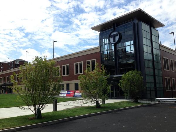 |
| In Beverly, a brand new $34 million palace for 500 cars: $68,000 per parking space. And the MBTA claims that they have no money. (pic source) |
While, in the meantime, people who walk to stations are treated to this:
The difference is simple: the MBTA primarily sees itself as a means for getting 9-to-5 commuters from parking lot to downtown office building. Their decisions make a lot more sense when viewed in that light. Of course, not everyone thinks like that, and there are good folks there trying really hard to make things better. But institutionally, the agency was born in 1964 and still thinks like it is 1964.
Going back to the big-ticket items listed in the PMT:
- The Red-Blue connection at Charles/MGH. An essential item if looming passenger capacity problems at Park Street are to be tackled. The Big Dig mitigation agreement required merely the design of the Red-Blue connection. Yet, the MBTA has now successfully dumped it. Even though doing the design would be cheaper than building the parking palaces on the North Shore.
- The Silver Line Phase III, which would unite the two halves of the Silver Line with a superstation underneath Boylston Station. SL-Waterfront is currently only connected to the Red Line at South Station. That was not intended to be the final state, and the line struggles as a result. Yet, Phase III was completely insane, and would have cost many billions of dollars to build, while digging up and throwing into disarray some of the most sensitive parts of historic Boston. As a result, it will never happen, and the Silver Line continues to look like one of the worst ideas in MBTA history (although it is an example of a non-BERy-planned expansion).
- The North/South Rail Link between North and South Stations. This was supposed to be part of the Big Dig and was deferred due to the collapse of that project's budget. If done correctly, the North/South Rail Link can be combined with a radical transformation of the commuter rail system to produce express rapid transit similar to the RER. That would be visionary and transformational to the region. Naturally, the MBTA has no interest in that, and may have actively sandbagged the proposal.
- Things like South Coast Rail, now costing $2.3 billion, to serve 4,500 people. You know how I feel about this one.
So that's where we stand with the MBTA's vision. Parking garages, dinky diesel powered traincars, insanely expensive commuter rail expansions, and a lot of pie-in-the-sky proposals. Mostly a collection of pet ideas and political footballs, really.
I think part of the problem is that the MBTA only sees itself as a transportation agency. It's a part of MassDOT now, which makes it part of a larger transportation agency. The same problems occur at the higher level too; we have seen, as MassDOT works on redesigning the Mass Pike through Allston, they insist on compartmentalizing themselves with the "we only build roads" attitude.
The transportation-only focus is broken: transportation and land use go together and must be considered together when making plans or changes. If I were to give a set of principles for the MBTA (and MassDOT) to use when considering their vision over the next fifty years, it might look something like this:
- What you build is what you get: “If you plan cities for cars and traffic, you get cars and traffic. If you plan for people and places, you get people and places.” -- Fred Kent
- Models are almost entirely useless, because the interaction between human beings and their built environment is too complex for us to reliably predict most things, especially decades in the future.
- Instead of trying to predict the future, focus on providing strong urban corridors that can adapt to any conditions. For the transportation side, that means safe, walkable, bikable streets with frequent, reliable, convenient and accessible transit service (of any mode). For the land use side, that means mixed, intense, diverse use that keeps the human scale in mind.
- To MassDOT: uphold the GreenDOT principles, the Mode Shift Goal, and the Healthy Transportation Compact.
- To MBTA: strengthen your frequent bus network through expansion and upgrades. Use "BRT" features on every bus route: off-board payment, all-door boarding, level-boarding, signal priority, bus lanes, etc. Stand up for your customers: don't be afraid to confront the automobile lobby when it's stealing resources away from bus riders. When designing and rebuilding suburban rapid transit and commuter rail stations, they should, as much as possible, be the core of a walkable town center -- not a parking lot desert.
- To MBTA commuter rail: it's time to stop operating like it's the 19th century. Start moving towards reliable frequency, all-day, supporting two-way travel wherever possible. Don't be just a parking lot shuttle, be a connection from the small, walkable town center to the larger region's opportunities.
- To urban/land use planners in the region: don't zone yourselves out. There's huge demand for nice places to live where it's not only safe to walk and bike, but also convenient and enjoyable. We used to build such places, until mid-century zoning made it illegal to do so, instead choosing to chase the impossible dream of automobile travel everywhere, all-the-time. Help build strong urban corridors through walkable neighbohoods, corridors that can be effectively served by transit, and work together with the MBTA to make it a reality.
At the beginning of this year I started to outline what a set of key urban corridors might look like for Boston. It's a rough draft and limited:
But the idea was to create a vision of where the MBTA and the city could work together in creating strong urban corridors, mostly based on existing bus routes. If the MBTA published a vision in this mold and said that "by 2024, here's where we want you to be able to catch a bus or a train within 10 minutes of showing up," that would be exciting. And if the city came along with a similar plan that said, "here's where we're going to focus on bringing economic development, on increasing housing supply, on fostering diversity, on walking, biking and safer streets," and that plan largely concurred with the MBTA's plan, then that would be exciting. And perhaps, it would represent a realistic vision that regular residents and riders could appreciate.
Sunday, April 6, 2014
Contrarianism gone wild: the over-hyping of a study about car access and poverty
It's good to consider different ideas and opinions that go against the usual thinking. But it really helps when those different ideas have at least an ounce of common sense or consideration for why they are not widely accepted. This recent study and article by Rolf Pendall, et al, is one such example. The authors found that housing voucher recipients who owned cars were more likely to retain employment and have better outcomes than recipients without cars. Not a terribly surprising or interesting result when considered in context as a correlation. But the authors seemed to have decided to get more juice out of it by slapping a controversial title on an article, "How Access to Cars Could Help the Poor", and then somehow implying that their study produced that result (while mincing words in the actual text). They also sucked in a journalist who really ought to know better, Emily Badger.
What's so bad about creating more car subsidies for the poor? Well, if you don't think any further, then it might be hard to find an objection. But anyone with a moment's thoughtfulness should ask this question: What about the young, the elderly, and the disabled?
Pushing and subsidizing cars just leads to worse conditions for the people who cannot drive; the people who are most often harmed by automobile-oriented policies. This so-called "solution" coming from Pendall and Badger is simply inequitable. Furthermore, it completely ignores the fact that we already give A LOT of subsidies for car ownership in this country, as it is. Cheap gas, cheap parking, free highways, etc. How is it possible that more subsidies are going to help? And what is the plan to help those who cannot drive at all?
Just look at what happens in other countries that accept subsidies and promote car ownership. It's more stark in countries that are not as rich as the United States, and where corruption rules. Mass motorization in the developing world is leading to nightmarish congestion, a hideous death toll, choking amounts of smog, and growing population that is being excluded from opportunity because they do not have a car or are unable to drive. Trying to force more cars onto people just exacerbates all these problems.
Deep in Pendall's article is buried this paragraph that walks back the headline assertion:
Advocates trying to help people lift themselves out of poverty will no doubt consider all sorts of means. In some cases, that might include helping people gain access to vehicles. But it would be the incredibly irresponsible to lean on a general policy that depends upon getting everyone into a private vehicle. First, and foremost, it excludes a large segment of the population. Second, it is very expensive, a burden on both parties. And finally, it does not solve the actual problem: it is just a band-aid for the distressingly inhuman public space and transportation policies of the past.
What's so bad about creating more car subsidies for the poor? Well, if you don't think any further, then it might be hard to find an objection. But anyone with a moment's thoughtfulness should ask this question: What about the young, the elderly, and the disabled?
Pushing and subsidizing cars just leads to worse conditions for the people who cannot drive; the people who are most often harmed by automobile-oriented policies. This so-called "solution" coming from Pendall and Badger is simply inequitable. Furthermore, it completely ignores the fact that we already give A LOT of subsidies for car ownership in this country, as it is. Cheap gas, cheap parking, free highways, etc. How is it possible that more subsidies are going to help? And what is the plan to help those who cannot drive at all?
Just look at what happens in other countries that accept subsidies and promote car ownership. It's more stark in countries that are not as rich as the United States, and where corruption rules. Mass motorization in the developing world is leading to nightmarish congestion, a hideous death toll, choking amounts of smog, and growing population that is being excluded from opportunity because they do not have a car or are unable to drive. Trying to force more cars onto people just exacerbates all these problems.
Deep in Pendall's article is buried this paragraph that walks back the headline assertion:
More research is needed to determine if the relationship is causal or associative, that is, whether the car is the catalyst or if there is something deeper at work, of which the car is simply one manifestation. Cars are expensive to purchase and to maintain, even more so for families with severely limited resources. A low-income household that is somehow able, inclined, or afforded the opportunity to buy a car might also do many other things to get ahead. Motivation, opportunity, or both could be key.Well, guess what. It doesn't take a genius to realize that a family stranded in an automobile-oriented environment is going to benefit from an automobile. But the cause of that problem is the automobile-dependency of their neighborhood. And nothing you do to promote car ownership, or even car access, is going to help the third of our population here in America that simply cannot or should not drive.
Advocates trying to help people lift themselves out of poverty will no doubt consider all sorts of means. In some cases, that might include helping people gain access to vehicles. But it would be the incredibly irresponsible to lean on a general policy that depends upon getting everyone into a private vehicle. First, and foremost, it excludes a large segment of the population. Second, it is very expensive, a burden on both parties. And finally, it does not solve the actual problem: it is just a band-aid for the distressingly inhuman public space and transportation policies of the past.
Tuesday, February 4, 2014
Boston's narrow streets are safest for walking and riding a bike: wide streets are the most dangerous.
 |
| A wide street, Brighton Ave: 80 feet wide. Chung-Wei Yang was killed by a bus here. |
But urban biking does present risks, especially in Boston with its narrow streets and aggressive drivers. In 2012, five cyclists were killed in accidents — though none in winter.This false, lazy sentiment about Boston's streets is unfortunately somewhat widespread. In fact, Boston doesn't really have many narrow streets. But, the narrow streets that Boston does have are one of its greatest advantages over other American cities.
In general, narrow streets are safer. From that study in Colorado:
“The most significant causal relationships to injury and accident were found to be street width and street curvature,” according to the report. “The analysis illustrates that as street width widens, accidents per mile per year increases exponentially, and that the safest residential street width is 24 feet (measured from curb face).”Even 24 feet is fairly wide (enough for two fast-moving traffic lanes), but that town did not have any smaller streets to study. Even without the research, it's easy to see that the main purpose of wide roads is to make it easier to drive faster -- and speed is the biggest danger to life and limb. One of the reasons New York City is having so many problems with street injury is because, other than a few, relatively small areas of Manhattan and Brooklyn, that city is cursed with extremely wide streets.
 |
| Huntington Ave (courtesy: Google): about 95 feet wide. Kelsey Rennebohm was killed by a bus here. |
 |
| Beacon St and Charlesgate West: at least 100 feet wide. Kanako Miura was killed by a dump truck here. |
 |
| Comm Ave at St Paul St (courtesy: Google): about 110 feet wide. Chris Weigl was killed by a tractor trailer here. |
Here's some more data. BPD identified several intersections which had the most crashes involving a bicyclist in 2012:
 |
| From Cyclist Safety Report 2013: most problematic intersections |
- Beacon St at Massachusetts Ave: 50 feet
- Massachusetts Ave at Beacon St/Comm Ave: 60 feet
- Harvard Ave at Brighton Ave: 50 feet
- Brighton Ave at Harvard Ave: 80 feet
- Comm Ave at Harvard Ave: 160 feet
- Huntington Ave at Belvedere St: 95 feet
- Belvedere St at Huntington Ave: 60 feet
- Columbus Ave at Cedar St: 70 feet
- Cedar St at Columbus Ave: 26 feet
All of those streets are very wide except for Cedar St; a small side street that is one of the only ways to walk or bike between two densely populated residential sections of Roxbury, and requires crossing the very dangerous Columbus Ave between two very long blocks.
 |
| Columbus Ave (courtesy: Google): about 65 feet wide. A woman was struck and killed here on Christmas Eve. |
I could keep going on and on, but I think I've made my point quite clear: wide streets are dangerous. Unfortunately, Boston has many wide streets, and it is very difficult to fix them once they are created. The best way to create safer streets is to build them narrower from the beginning. But in the rare cases where we have that opportunity, we are still building wide streets because people do not know or understand the danger. Engineers claim to try and anticipate future traffic growth, and they do not consider the costs of the wider streets at all. Fire marshals want wider streets and turning radii for their trucks, but they don't think about the people who will be killed or injured by those design choices. Architects like wide streets because it feeds their egos: they're always trying to build the next "grand Parisian boulevard" and, at least in the bad old days, they could care less about the human cost. Even the new planners, with their "complete streets", tend to favor wider streets: to squeeze more stuff onto. That is unfortunate. Complete streets should be seen as a way to reduce the danger of overly wide streets, not as an excuse to make the mistake of building wider streets from the start.
If we want streets to be safer in the future, what we really need is a program which encourages narrow, human-scaled streets, and also celebrates the narrow streets that we have inherited from the past.
Saturday, January 25, 2014
weMove Massachusetts: A disappointing, flawed plan for performance metrics that will repeat the mistakes of the past

This month, MassDOT announced a new plan called "weMove Massachusetts" which introduces the idea of using performance metrics to help plan investment in transportation. Sounds good, right? I was looking forward to reading about a scientific approach towards selecting projects that help people access the opportunities in their lives, while steering towards overall goals like "GreenDOT." But instead of that, when I read the report, I found the same bad old attitude that you also find at the Texas Transportation Institute. The main automobile measure is regressive. The sole metric for bicycle usage is almost completely useless. The transit metrics range from irrelevant, to poorly designed, down to outright worthless. There are no walking metrics in the report. Many of the metrics don't even involve actually measuring anything in the real world!
Metrics have consequences
Before I go into the specifics, let's take a quick step back and think about what we actually want out of our transportation metrics. There are two main ways of looking at transportation broadly, and both have their uses, depending on context: mobility vs accessibility.Mobility measures the amount of traveling you are able to do: e.g.
- How fast can you go?
- How far can you go?
- How easy is it to move around?
Accessibility measures the amount of opportunity that is open to you because of transportation: e.g.
- How many jobs/needs/activities can you reach in a reasonable amount of time?
- How many choices do you have about getting to your destinations?
- How is your quality of life improved by transportation?
These are not completely distinct viewpoints. For example, you could increase the number of jobs available to you by improving the speed of transportation. On the other hand, you could also achieve the same by having the economy add more jobs within your existing range, or by moving to a region with more job density. The latter is, broadly and superficially, the way cities form.
However, choice of viewpoints does matter when trying to put together cost/benefit analysis for new transportation projects, and it is very important to choose carefully. A metric is a convenient number which tells you something useful, but it is also an intentional oversimplification which can lead you astray if not used judiciously. Unfortunately, our MPO has a history of abusing metrics, and traffic engineers are infamous for applying the wrong tools to our cities, causing terrible destruction in the process.
Is there an ideal general metric at all? I don't think so, but the closest one I believe is the last example I cited above: "How is your quality of life improved by transportation?" Ultimately, transportation is about giving you the ability to live your life as you see fit, to take advantage of the opportunities open to you, and to keep you safe while doing it. The problem with this formulation is that it is very vague and broad, making it difficult to quantify. That's intentional: "quality of life" means as many different things as there are different people, so there really is no one way to interpret this. Instead, when designing performance metrics that are more easily quantifiable, this principle is what you should be striving to justify your decisions by: how does your work help people live the life that they want to live?
Without further ado, I will jump into the "weMove Massachusetts" report and its many flaws:
Pavement, Bridges

I've grouped these two together because they have a similarity: obviously you don't want roads to crumble or bridges to collapse. But, the metrics assume that the status quo is sustainable and desirable, and all that is needed is an influx of money to repair what we have. A very, very large influx of money: $544 million a year on Pavement and $447 million a year on Bridges. That's a billion dollars a year for what will basically only benefit motor vehicle modes. This is not to deny the need for such repairs or such infrastructure. We need some of it. But do we need ALL of it? There should be some cost/benefit analysis applied to the two largest line items in the transportation budget. These metrics do not enable that. There is no consideration given to whether a lane diet might be a better way to go, for safety and money-saving purposes. And there is no consideration given to whether an overpass should be removed instead of rebuilt, even though 1950s traffic levels on it long ago disappeared. Is every square inch of asphalt sacred? Must we continue to perpetuate the mistakes of our forebears, at any cost, without thought?
Mobility

This metric is one of the worst in the document. It's basically lifted straight from the highway-crazed Texas Transportation Institute. Sure, this metric is fairly easy to quantify, but it reduces the whole notion of "mobility" down to one, highly confounded number: hours of delay per 1,000 miles traveled in a private vehicle. To understand why this is a bad metric, even from a driver's standpoint, consider the following tale of two commuters, Alice and Bob:
Alice lives in Waltham and works at an office near Rt 128 in Waltham, about 2 miles away. Under ideal conditions, her commute travel time is 5 minutes by car. However, under typically congested circumstances, it usually takes her about 10 minutes by car.
Bob lives in West Stockbridge and works at a shop in Westfield, about 40 miles away. Thanks to the sparse population, Bob can almost always drive 60 mph from start to finish, for a commute travel time of 40 minutes each way.
I cannot speak for the relative happiness of Alice and Bob, since it would depend on their (fictional) personalities. However, I can point out that Alice only spends 20 minutes a day commuting, while Bob spends 80 minutes a day just getting between home and work. Yet, according to this "mobility" metric of MassDOT, Alice is suffering terribly from delays, while Bob is doing great. Assuming 250 working days per year, Alice puts in 1,000 VMT/year for her commute, and experiences "delay" of 41.6 hours/year.
Viewed through the prism of this mobility metric, the DOT would rate Alice's commuting experience as being miserable, slow, and hellish. But that doesn't make sense from a common sense perspective. Alice only has a 10 minute commute! I bet most people would love to be in her situation, rather than being stuck in a car slogging it out 40 minutes each way. The DOT's metric is completely at odds with the principle of "improving quality of life." Not only that, the metric completely ignores all other modes of transportation. Two miles is not that far. That could even be walkable on a daily basis. It's easily bikeable within 15 minutes. If Alice is the sort of person who values getting exercise to and from work, it could easily be made possible. Or perhaps she would rather take a bus, the 70A, and do some reading on the 15 minute trip. Bob has none of those options: he is a captive car commuter. The only option he has is to car pool with someone else. But the metric doesn't even care about that: since it measures vehicle-delay rather than person-delay, your passengers may as well not exist.
The story of Alice and Bob is a bit too neat, obviously: in the real world, there are many other factors. But it's meant to illustrate a point: the mobility metric chosen by MassDOT is aimed in the wrong direction. The metric of "delay per vehicle-mile" is not designed to produce good transportation outcomes for people, but rather, to produce more funding for expensive road-widening projects which line the pockets of connected contractors and please the egos of highway engineers. The footnote to this metric tells it all:
Funding for mobility projects includes any projects that will increase roadway system capacity such as additional lanes, bottleneck removal, intersection improvements, etc.
MassDOT will claim that Alice is "suffering" from tremendous delay as justification for widening the streets in her neighborhood, installation of fancy traffic engineering techniques such as grade separation and complicated traffic signal phases. All of which will degrade the quality of life in her neighborhood. To be fair, in this day and age most of that will be shouted down by commuter opposition, but this is the same kind of metric that was used to shove these kinds of "improvements" down the throats of our communities in the past. More insidiously, planners will use this delay metric as justification for furthering suburban sprawl, instead of creating compact, walkable neighborhoods. The "delay per vehicle-mile" metric is complete garbage and thoroughly inappropriate for an agency which claims to be about promoting "smart growth" and "green travel" mode shift.
Safety

Safety is important. Everyone knows that. But, this particular way of doing it is an example of a metric which sounds good at first, but is actually quite mediocre, or downright dangerous, when you look at the details of how it is actually implemented. Why is there a focus only on intersections and interchanges. That seems strange. Although those are certainly higher risk locations, crashes can happen at any place. Why the restriction? The answer is found in another section which fills in some of the details:
Roadway safety is typically measured by the number of crashes. Crash rates cannot be easily projected into the future using the types of performance curves applied to other highway metrics. Therefore, safety performance was measured by the number of high-crash locations that can be improved over time for an average cost of $500,000/intersection.So basically, they claim that they cannot get a good metric for "crashes prevented per dollar" and therefore, as a proxy, they will just count the number of intersection projects that can be funded, assuming half-million dollars each. Here's a litany of problems with this approach:
- There's nothing about "intersection improvements" which necessarily implies better safety.
- DOTs have a history of making "improvements" that make streets more dangerous for walking and biking. For example, street widening is sometimes considered a "safety improvement" even though it will end up producing more injuries, particularly to vulnerable road users.
- The real danger to safety comes from speeding vehicles. Again, "intersection improvements" says nothing about this, and the metric is completely mum about speeding elsewhere on the street.
- The metric encourages spending money on intersections and interchanges, but it does not actually measure whether that money was spent in a worthwhile way.
- It assumes that spending a half-million dollars is all that you need to do to "fix" an intersection.
- Severity of crashes is not considered at all. If you had to pick a design based on safety consequences, which would you select? (a) One person will die each year in a severe crash, or (b) ten people will be slightly injured a year in minor crashes. Obviously, zero injuries or deaths is best, but if you had to choose, then I think that (b) is a much better outcome. The metric considers none of that.
If you are going to adopt performance metrics, then you should actually go out and measure something in the real world. This so-called "safety metric" does not do that: instead it simply divides the amount of money available by the number of intersections, and calls it a day.
Bicycling

Behold, the only bicycle-focused metric in the entire report. The main mobility metric only focuses on cars, so this one should partially make up for that, right? Right? Yeah right. This metric is the first one in the report where you start to think that this whole document is really just a long, boring joke. If you try to consider it, there are a variety of ways you might go about quantifying bicycle performance (not endorsing any particular one): bicycle-miles traveled, % mode share bicycling, % population that owns a bicycle, % population that considers bicycling, number of comments on the Internet complaining about bicyclists, etc. What all these metrics have in common is that they involve making measurements in the real world: something must actually be counted, a number that cannot simply be conjured out of thin air.
This is in stark contrast to the proposed MassDOT metric: completion % of the Bay State Greenway, a network of off-street cycle paths. The DOT's metric is computed by looking at the budget documents and comparing whether or not the Bay State Greenway is funded under both budget scenarios. Since it is, the metric is set at 0% from now until the end of time. The genius who put this one together probably thought he or she was pretty clever to insert a "performance metric" which required a grand total of 30 seconds of work behind a desk, and will never need to be revisited again.
Complete and utter failure. Secretary Davey, this is a disgrace.
Walking
Just kidding. There are no walking metrics in the report. Well, I suppose you could pray that the "Safety" metric will bring "intersection improvements" that actually benefit pedestrians, and that the "Mobility" metric does not end up destroying the walkability of streets which used to be safe before the traffic engineers got their hands on them.
Transit
The tone of the report changes once it reaches the transit metrics. Prior to this, the metrics were somewhat broad or simplistic, but the transit metrics are very precisely chosen. Unfortunately, they are chosen rather poorly for planning purposes. I was told by some MPO staff that the MBTA was responsible for their metrics, and that does seem to be the case because these metrics are largely only of interest to someone working in the T's maintenance department. Since there are so many, I will group a bunch together and address them at once:
- MBTA Bridge condition: the % of bridges that are in state of good repair.
- MBTA Elevator/Escalator condition: the % of elevators/escalators that are in state of good repair.
- MBTA Station Accessibility: the % of stations that comply with the Americans with Disabilities Act and the MA Architectural Access Board standards.
- MBTA/RTA Bus and Train performance: the % of vehicles in state of good repair.
- MBTA Signal performance: the number of annual signal failures.
All of these metrics are important -- to the people in charge of maintaining the system. However, these metrics are fairly irrelevant to the average customer. Reliability is important to the customer, certainly, but we don't go through the trouble of providing public transportation because we really like to do bridge or signal maintenance: the purpose, the reason for existence of the system, is making transportation available to people. People want to know that when they show up at a train or bus station, a vehicle will arrive in a reasonable amount of time. They want a system which gets them where they need to go, which gives them access to the city region and all of the opportunities contained within. Specific "state of good repair" statistics are part of the internal implementation of reliability. I suppose it's fair enough that they are being open about it and including it in the report. Fine. But then, where are the metrics which actually measure what people want out of a public transportation system? Not present in this report. Maybe the closest is another maintenance statistic:

Again, we have a performance metric based on delay, like what cars get. Good? Not quite. One improvement is, at least in this case, positive values don't imply a need for highly destructive road widening, since that is not on the table. So, improvements to delay are probably all upside, no downside other than cost. What else could be wrong? Well, it's another case of the same disease which seems to periodically infect planning at the Boston MPO and the DOT: vehicle-itis, the curious syndrome in which transportation agencies forget that their job is to help human beings, and instead focus entirely on pieces of steel and fiberglass.
This metric, like the mobility metric before, only focuses on the delay to vehicles, rather than people! In the other case, you might shrug it off because the average car only carries a few people at a time (although that attitude still screws over carpools). But it is huge loss when you neglect to account for the fact that a train could easily be carrying over five hundred people who are all delayed when the vehicle is delayed. The next time the Red Line breaks down, think about this: the MBTA, MassDOT, and the Boston MPO have all committed to the belief that your time, as a transit rider, is only worth 1/500th the value of anyone who happens to drive alone in their car.
A lot of perversity about our transportation system can likely be explained by this attitude:
- The ever-increasing insertion of delays into the routine of T travel. From completely pointless, customer-loathing tactics like "Front Door Only alighting," to random "safety stops in the middle of tunnels" that are never fixed, to schedule management that hasn't changed since the early 20th century, to deferred maintenance up the wazoo, it's all part of a culture of not caring about the riders on-board the vehicles.
- The continuing refusal to use signal priority for transit vehicles on the surface. Both Beacon St and Huntington Ave have the technology installed to do it. But the MBTA can't be bothered to implement this modern technique which is used all over the country and the world. In their eyes, a train with 300 people on board is not worthy of causing ten seconds of delay to a precious private automobile.
- An almost complete lack of bus lanes outside of the gimmick lanes on Washington St -- which don't extend into the part of the city where bus lanes are desperately needed. This one's on BTD as well, but the MBTA should be pushing hard to improve the ridiculously slow speed of its buses.
- The achingly slow turnaround time on the barest of improvements. The key bus route improvement project took about three years. Not because it was hard (it's not). Not because it was expensive (it wasn't). But because nothing happened for two years and then finally bus stops started getting moved, and painted in the street, within a few months at the end of last year.
- The truly pathetic state of some of the stations, particularly on the surface, where there's nothing more than a few feet of asphalt with cars zooming by, inches from your body. And that's on a section of roadway that was rebuilt relatively recently!
- The fingernail-pulling it takes to get sidewalks, crosswalks and bus stops shoveled clear of snow around here.
Choosing good metrics for transit is not easy, as it depends on the context and what you are trying to accomplish. But you cannot reasonably plan a transit system without using metrics which count people. Some examples of useful mobility-style metrics might include, but are not limited to: boardings per mile, net cost per passenger, average passenger load, or number of people unable to board vehicle due to crowding. Some examples of useful accessibility-style metrics are: number of jobs available within a 30 minute transit trip, number of people within a 5 minute walk of a frequent transit stop, number of people with disabilities who successfully navigate your fixed-route system, or percentage of riders who claim [dis]satisfaction with the transit system.
Conclusion
I know that I have been a bit crass about the problem here, but it is only because a strong tone is necessary. The "weMove Massachusetts" plan is terrifyingly terrible. It represents a large step backwards, encoding 1950s-style thinking about highways into a document which pays lip service to "smart growth" and "green travel" but does nothing to promote either. It is so bad, that I can only recommend one course of action: rip up the "weMove Massachusetts" document and start over from scratch. This time, choose empirical metrics which require real-world measurements, categorize them under either "mobility" or "accessibility," and justify why the people of Massachusetts should care about the metrics. I propose that the guiding principle be: "transportation investments that improve the quality of life of people in the Commonwealth" but I am open to suggestions.
I also want to add a note about GreenDOT: supposedly, it is a goal of MassDOT to triple the mode share of walking, bicycling, and taking public transportation. This report talked about that goal but, like with many other things, did not really go into any significant detail about it. However, I did hear from MPO staffers that the metric used will be "person-miles" for each of the "green modes." In other words, the Commonwealth of Massachusetts will either seek to encourage three times as many people to walk, bike, and ride transit; or, the Commonwealth will seek to force all current walkers, bikers and transit-riders to travel three times as far as they do today. According to the metric, either one works. Okay, that sounds a bit ridiculous, but that's because "person-miles" is not a good metric for walking, biking or public transportation in cities. If you want more details, read those links, but suffice to say: there's no public good served by forcing people to walk, bike or ride buses further and further away. Distance is not a virtue in itself.
I just wish that the people who put together metrics at our departments of transportation, and our organizations of planning, would put in even an ounce of thought into their work.
For more reading on metrics, and mobility vs accessibility, I recommend this paper by Todd Litman.
Subscribe to:
Posts (Atom)