Pages

Showing posts with label modeling. Show all posts

Monday, June 15, 2015

Might does not make right

Years ago, when I was learning how to drive, my mother made sure to emphasize the fact that a motor vehicle is a lethal weapon. Nearly two tons of steel and plastic, moving at speed, is dangerous when misused or mishandled. That's not cause to be passive, but rather, to be cognizant of the consequences and continually vigilant. As a teenager, it was easy to get excited about the new power available to me, while not considering the risks, nor giving thought to others in the world around me -- except as obstacles. And like most Americans, I managed to make it through those years without serious incident, despite some mistakes, with the help of a few lucky breaks here and there. Because I was okay personally, I didn't think much beyond that, at the time.

Having spent several years on walking, bicycling and transit advocacy, I have a different, "outside-the-windshield" perspective on these matters nowadays. The power of the motor vehicle I can still appreciate, but I can also see how it is too easily abused. With one barely perceptible pedal push, a driver can blast past a child waiting at a crosswalk, and hardly notice at all. Or seeing brake lights ahead, a driver swerves to pass the one car that had yielded, and barely skims past a person crossing the street. The noise, grit, and grime caused by the passage of fast-moving motor vehicles is out-of-sight, out-of-mind to those drivers that create it. Even if nobody is physically harmed, the physical characteristics of living environments that facilitate speeding, heavy vehicles are unfriendly to human beings.

To behave humanely behind the wheel takes hard work, and a commitment to consider the other people around you. "Might does not make right" is the ethical principle that I believe is most applicable to transportation projects in our cities and towns. My feeling is that we have an obligation to protect the vulnerable from the powerful, and not only to protect, but to promote and serve. That is what forms the ethical basis of what I try to do.

The coalition of people who promote automobile interests are usually very strong, very rich, and very powerful. Motor vehicles are expensive to own, to maintain, and are highly wasteful of space. Any available room on the roads is quickly consumed by even a small increase in the number of vehicles. The resulting congestion can be enraging to drivers, as their expensive and powerful machines are trapped in a mire of their own making. At both home and destinations, without a readily accessible 300 square-foot piece of land for storage, these machines become a enormous burden on their owners, who then proceed to lash out in frustration.

Automobiles can provide convenient and quick transportation when everything works out, but when the systems quite frequently fail, the problems that stack up are often 'solved' at the expense of other people, especially the most vulnerable. Sidewalks are narrowed. Trees are cut down. Crosswalks eliminated. Bike facilities are completely omitted. Fences are put up. Transit is dis-invested. Highways are blasted through neighborhoods. Children aren't allowed to walk to school, or the park. Desperately needed housing development is canceled for imagined fear of "parking problems." Economic growth is stifled because "it might cause traffic." We can no longer properly build cities for people because all of our modern rules and regulations are designed to produce cities that only a machine could love.

Motor vehicles are powerful, and many of the people who own them are powerful. Motor vehicles are also very useful, and are a great boon to our civilization when used safely and prudently, within reasonable limits. But that does not make it right to give in to their every need. Without check they would take away our land, our natural resources, and the quality of our air. Thankfully, over the past several decades, the work of countless citizens has produced some legislative and political help, through endless community organizing. It's a continuing effort, and it's very important that everyone participate. Being obstructive is not enough: a great deal of damage was done by the Utopian automobile idealists of the 1950s who never gave any thought to the communities that were harmed by their schemes. That damage has yet to be repaired in many cases.

To give a concrete example: on June 17th, MassDOT will present the latest installment in the ongoing saga to rebuild the Allston Mass Pike interchange (6:30 pm, Jackson-Mann school). Fifty years ago, the Mass Pike extension widened the railroad right-of-way, taking houses, and leaving behind a huge scar across the Allston/Brighton neighborhood that has never been properly managed. The crossings are decrepit and crumbling, and not accessible to many people with disabilities. The streets that were rebuilt back then were given designs that had almost no consideration for people on foot, much less on bicycle. Dangerous highway ramps cut in at sections that seem to be designed to interstate highway-spec, despite being city streets.

Some bike lanes were painted in an effort to try and do something, anything at all, but despite the well-meaning effort, the street remains a major problem.
Two years ago, the Patrick administration announced a project that had the potential to fix all kinds of problems with the interchange. A dangerous curve in the highway would be straightened. The old-fashioned tollbooths would be replaced with modern, automated systems. The whole mess of city streets left behind by the 1960s extension project could be reworked, finally reuniting North Allston with south, and building a whole new neighborhood in between. And to top it off, a new 'West Station' on the Worcester line would finally give Allston back a railroad station somewhat near the site of the original station around which the community was founded.

But it seems that potential is being squandered. Despite months of community engagement and a professed commitment to "multi-modal thinking", the design team went off for the winter and nothing came out until finally this June meeting was announced with this plan shown, that seems to have more space allocated to roadway than non-roadway:
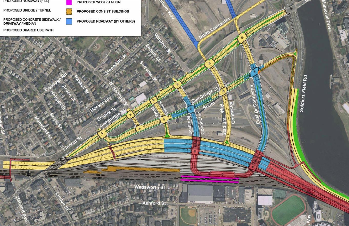

In the past year, the DOT design team told us often that they "don't do city planning" and it appears that they don't intend anyone else to do so either. It's hard to imagine anything neighborly fitting between those massive connectors (that will rise on earthen berms above grade, by the way). West Station is included, but can you imagine making the connection to or through that while walking precariously on a pathway above 10-12 lanes of roaring highway and some number of railyard tracks? This design is a highway design, engineered for the comfort of drivers first, and everyone else second. Yes, it's an improvement over the old ways, in that it will all satisfy accessibility regulations, and there are connected sidewalks and protected bike lanes. But with this car-first design, it seems that those facilities will only be used by necessity, not by choice.

We have often been told that "the computer models" require this many lanes, or that size an intersection, etc. The models, of course, have been programmed by engineers to try and predict the future. They say that they can tell us what the behavior of people in the year 2035 will be, with precision. They will tell us that unless they build all of this road space, we will be threatened by some kind of 'traffic armageddon'. It's a bullying tactic, plain and simple. Common sense should tell anyone that trying to predict the future is impossible, much less making precise predictions about conditions on a particular road 20 years from now. The models that they create are nothing but a set of equations and parameters chosen by the people who designed it. These models are as fallible as the people behind them, and can be used to say anything at all. Usually, they are used to say whatever it is the people who hired the modelers want them to say.

In this case, the powerful have spoken, and they have said that they want more automobile capacity in our neighborhood, at our expense. Whenever you hear an engineer say "the models predict increased traffic by X" what you should translate that to is "automobile interests want increased capacity by X, and nothing else matters."

Let's contrast this situation with what it might be like if MassDOT took the other side and tried to help provide space for a new neighborhood with good connections to the surroundings. Then the street network would be laid out at a human scale, with smaller blocks, smaller streets, and a collaboration with city planners in Boston. When it came time to talk about automobile capacity, instead of sending us an ultimatum that "we must tolerate a massive additional influx of vehicles or else", they would calculate the maximum capacity that is compatible with the city planning goals, and work to keep demand for the highway under that level. For example, perhaps it could be considered that commuter bus or train tickets should not be more expensive than paying the toll on the highway. Or that all employers that offer parking benefits must also offer 'parking cash-out' as a benefit for people who chose not to drive.

The reason that this way of working is so tough for them to do, politically, is because it requires that they go to the powerful automobile-promoting interests and tell them: there is a limit, and beyond that, demand for the road is going to have to be managed somehow. An ever-increasing level of traffic on the Mass Pike is not an inevitability. That will only happen so long as more capacity is forced on us, so long as officials are too timid to use the tools of transportation demand management to control the problem at its source, and so long as might makes the right-of-way.

Sunday, November 2, 2014

Induced demand is a real problem and it makes congestion relief nearly impossible

For some reason, contrarian articles on "induced demand" seem to be the topic du jour. While they are right to point out that induced demand is a more subtle and nuanced concept than the way it is sometimes popularly handled, both articles seem to err too far in the other direction. Induced demand is a real problem, even if some people sometimes misuse it when making arguments.

Reliability, frequency, and speed


I want to take a quick detour to talk about goals in transportation investment. People tend to make decisions about transportation based on many factors, which I will boil down into three: reliability, frequency, and speed. Reliability encompasses factors such as predictability of trip time, probability of vehicle breakdown, and in general, the ability to make a confident statement about your location at a future time. Frequency is a metric of opportunity: the number of chances that will you have to undertake your trip in the window of time that you have available. And speed is the cost of the trip in time. To be sure, there is some crossover: frequency affects average speed and predictability, for instance. But let's roll with this for now.

There are two major categories: scheduled transportation and unscheduled transportation. Scheduled transportation is largely mass transit, whether public or private. Unscheduled transportation includes modes such as walking, biking and most driving. Frequency is obviously a huge deal for transit; there is also a frequency limitation on unscheduled transportation caused by things like traffic signals, but it is usually small enough to go without notice.

For many people, reliability is the most important characteristic. Walking and biking tend to have the most reliability because they are the least complex modes. Transit with a dedicated right-of-way is also supposed to be highly reliable: a properly run railroad should operate like clockwork (the MBTA on the other hand...). Modes such as driving are very susceptible to being caught in unpredictable and chaotic traffic congestion because they are highly inefficient in terms of space. Cars are also complex pieces of machinery that can easily break down. And mixed-traffic transit gets the worst of it because it has to contend with traffic congestion as well as passenger loading.

Speed should be broken down into average and top speed. Walking is obviously the slowest in average and top speed. Biking does not have high top speed (for most people) but can often maintain decent average speed comparable to a local city bus or a slow train. Transit can vary depending upon quality of right-of-way and maintenance. Driving is usually the mode with highest top speed but in typical traffic conditions can have significantly slower average speeds; possibly even slower than transit or biking.

The speed and reliability of walking is almost always independent of the number of people walking, except in the extreme cases (important as they are). Biking is also mostly able to enjoy that same feature. Transit in a dedicated right-of-way has the capability of operating reliably independent of the number of people attempting to ride it -- up to a point. Once the number of people reaches a certain "crush" capacity then dwell times can be impacted if the operator takes no further action. Finally, driving and mixed-traffic transit are most clearly the modes that are bothered the most by other vehicles on the road. As a driver, or as a mixed-traffic transit rider, the reliability and speed of your trip is highly dependent upon the decisions made by thousands of other people.

Perception and reality don't always match. For example, many people perceive to be in "more control" when driving. But in fact, they're highly dependent on the behavior of other people. Another: many transit riders don't perceive slowness because they are absorbed in some other activity such as reading or working; whereas drivers traveling at the same average speed might be seething and pounding the steering wheel in frustration. And of course: "There is a very strong element of psychology behind traffic patterns."

So, when considering a transportation investment, there are multiple ways to increase capacity. But they do not all have the same effect, even when viewed in such an abstract fashion.

Induced demand


Halloween just passed, so let's talk about candy. Prior to Halloween, there is a high, and one might say inelastic, demand for candy. Many people want to buy candy for Halloween, almost no matter what. This usually shows up in stores as an increase in both supply and prices. Luckily for kids (and the young at heart), supply of candy is relatively easy to increase.

Post-Halloween, the demand drops off. People remember why they don't binge on candy, or let their kids do so, all year. Excess supply is sold off as prices drop in response to the lower, much more elastic, demand. Then the market returns to normal, at least, until the next spike in demand.

Normally, I don't eat much candy. I try to avoid too much sugar for health and personal reasons. And I don't want to spend money on something like that. I could easily go for weeks and months without having a piece of candy. But if you put a bowl of chocolates in front of me, I'll probably take one sooner or later. The low price and ready supply has literally induced my demand. But not every type of candy will have this effect. I'm mostly not a fan of hard candy and will probably just ignore it. And perhaps I've generated economic activity by consuming a piece of chocolate, but I may also be ruining my diet and harming my health.

You probably guessed where I'm going with this. One major difference between candy and transportation is that the supply of the latter is much, much harder to increase. With transportation, very large, very expensive fixed investments are usually expected to accommodate all fluctuations in demand over time. Furthermore, in the United States, people generally do not expect the nominal monetary cost of everyday transportation to vary based on supply and demand, even though prices regularly change for commodities such as candy, food and other items. Instead, the cost fluctuation of everyday transportation is usually expressed as traffic congestion or overcrowding.

When a transportation investment is made, it can both increase the supply and possibly lower the overall cost of travel (either perceived or real) in that corridor. And the way that travel patterns change is hard to predict, despite many efforts.

Former Bostonian, and now Los Angeles transportation blogger VamonosLA writes:
In a large city, there’s almost always going to be trips that people want to make but don’t because of large travel times. This is especially true in large US cities, where we underprice road capacity to the point that new lanes are almost always quickly filled. We misinterpret the construction of the new lane as having caused the demand, but it was there all along.
This is true but is only part of the story. To be sure, some trips generated do represent increased economic activity. Other trips might represent less efficient usage of the now-cheaper resource. For example, you might make multiple trips where one would have sufficed in the past. Or, it might be due to drivers who were enticed into giving up existing car-pools, or who ditched transit. They might even have switched from walking or biking in cases where the distances were feasible (perhaps not in LA).

For a rather stark example, suppose you live in a neighborhood with sidewalks and you are able to walk for many trips. Suddenly, the DOT decides to "improve transportation" by taking away your sidewalks and replacing them with additional car travel lanes. Most people would then choose to stop walking and start driving everywhere. Nowadays it seems unimaginable that such a thing would happen, but it has in the past, and continues to a lesser extreme: oftentimes it is not that sidewalks are removed entirely, but rather, walking is made more unpleasant for the benefit of motor vehicle traffic.

An unknown contributor to the Transportationist named JW writes:
I hate the term “Induced Demand”. I hate the idea that induced demand is something bad; something to be avoided. 
[...] From the individual’s point of view, access provides opportunities to more jobs, more entertainment and social options, and more alternatives for consumption of goods and services. From a business’ point of view, access provides a larger pool of labor and more raw materials. From a retailer’s point of view, access provides a larger pool of consumers. From a municipal government’s point of view, access allows more efficient provision of police protection, fire protection and ambulance service by reducing the number of facilities necessary for a given response time. 
[...] Transportation improvements that provide greater access per unit of time lower transaction costs. Lower transaction cost lead to great efficiency in the economy and a higher standard of living.
Although JW is careful to couch it in terms of access, which is a good thing, this otherwise sounds like an argument that could be lifted straight out of a 1950s highway builder's manual: new highways lead to greater efficiency and higher standard of living! According to this logic, the congestion on the new highway facilities justifies the construction of even more highways. Clearly something is broken in this reasoning.

The mistake that JW is making is that not all transportation improvements are equal, and that there are more considerations than just raw "access per unit of time", which itself is a difficult thing to measure in practice. For one thing, the increase in access by one mode (say, private car) can lead to the degradation in access by another mode (such as walking, or emergency vehicles). For another, some modes lead to far more pollution and other bad side effects like poor urban planning decisions (e.g. minimum parking requirements, urban renewal, pro-sprawl zoning laws, etc).

Congestion relief


But I think that by far the biggest confusion stemming from the debate around induced demand comes because people are often talking about different things. When highway builders are trying to sell expansion, and when the general public is getting excited about it, they often refer to "congestion relief" as the major feature of the proposal. But what is "congestion relief?" Is congestion relief equivalent to the fact that more people can travel more miles by car? Is congestion relief the possibly increased economic activity and higher standard of living that JW talks about? Is congestion relief the fulfillment of "latent demand" as described by VamonosLA?

I would argue that congestion relief is none of those things in the popular understanding of the term. Instead, congestion relief is generally understood to be an increase in reliability of travel and a subjective decrease in the frustration that each individual has when using the transportation facility. Highway builders sell highway expansion to a public that is hungry for predictable travel times and less stress behind the wheel. However, that sort of congestion relief is largely a false hope, precisely because of the phenomenon that has come to be known as induced demand. It doesn't matter whether that comes from latent demand, or even that it might represent increased economic activity: if the typical driver still experiences large variance in travel times, and high levels of stress, then the congestion relief was a mirage as far as he or she is concerned.

Even the level of spending associated with projects like the Big Dig did not make it immune from this effect. From the Globe:
A Globe analysis of state highway data documents what many motorists have come to realize since the new Central Artery tunnels were completed: While the Big Dig achieved its goal of freeing up highway traffic downtown, the bottlenecks were only pushed outward, as more drivers jockey for the limited space on the major commuting routes.

Ultimately, many motorists going to and from the suburbs at peak rush hours are spending more time stuck in traffic, not less. The phenomenon is a result of a surge in drivers crowding onto highways - an ironic byproduct of the Big Dig's success in clearing away downtown traffic jams.

[...] The findings also call into question the promises made when ground was broken in 1992. At the time, state officials said in a promotional mass mailing to the public that, when it was all done, "people will find the commute to their jobs faster and easier than ever."
The new tunnels may have been able to handle the flow coming into them, but those outer links themselves were not able to live up to the induced demand.

Conclusion


So what can be done about congestion, then? It has rightly been pointed out that transit improvement and biking facilities do not "reduce congestion" in this sense. Actually that point should be clarified further: those improvements do not "reduce congestion" when the travel demand is virtually inexhaustible. However, it is possible that in some cases demand is actually exhaustible: for example travel along Comm Ave in Allston, in which case those kinds of improvements can be very effective at real congestion relief. But for destinations such as downtown Boston, there will almost always be another driver willing to replace a trip that is mode-switched away from private vehicle.

All that does not make transit, walking and biking improvements worthless. Jarrett has discussed several reasons why transit is still very worthwhile even without "congestion reduction" and I won't reiterate, but I will add that dedicated-lane transit, walking and biking facilities all increase the supply of "reliable transportation" that boosts accessibility without the harmful side effects imposed by increased car travel. Walking and biking also have great implications for the health of urban neighborhoods and are worthwhile goals on their own.

The idea behind congestion relief is to try and make personal motor vehicles as reliable as walking, biking, or riding a well-run railroad. There are only two known ways to make that actually happen: (a) rigorous scheduling, or (b) decongestion pricing. Railroads avoid congestion and conflict by imposing very strict discipline and heavily analyzed schedules on the movement of trains. To try and apply that same discipline to private cars on roads is politically and practically unfeasible. Therefore that leaves decongestion pricing as the only known way to make private motor vehicle travel reliable, and it works by allowing the price of travel to vary based upon the supply and demand for travel. This is, of course, standard procedure for allocating just about every other resource in our society, but for some reason is completely ignored when it comes to roads. In any case, this article is about induced demand and I have already gone on too long, so I will leave discussion of pricing to others.

Tuesday, December 10, 2013

Thought experiment: how much bus service can you get for the price of a parking garage?

Looking through some old data, I noticed that there's a common theme: the marginal operating cost per weekday of your typical frequent MBTA bus route is about $20,000. For example, the 1 bus is $18,456 while the 39 is $22,206. The 57 comes in at about $19,544. All of them are estimated to recover approximately half of that in fares, so overall marginal subsidy per day is about $8,000 to $12,000.

Mind you, the marginal operating cost only factors in the cost of running a bus per hour, plus the cost of driving it per mile. Maintenance, depreciation, administration and other facilities are not covered. But if they had the equipment lying around, then it might be fair to say that adding a weekday's worth of 57-like bus service costs approximately $10,000.

We know that excavating an underground parking garage can cost from $50,000 to $100,000 per parking space (sometimes more, sometimes less, depending on conditions). Speaking loosely, then, each underground parking space could cover the net cost of approximately 5-10 weekdays worth of key bus route service. Let's just assume for simplicity that every day has the same cost as a weekday. Then a year's worth of key bus route service could be covered for the same cost as 36 to 73 underground parking spaces.

A year's worth of bus service. (photo source)
Does this come up in real life? I think it's fair to expect several hundred parking spaces to be built along every core bus line every year. I can think of several hundred that came online along Comm Ave just last year, including some built at a deep (expensive) level. And another few hundred planned for Washington Street in Brighton. The Fenway is seeing plenty of garage construction despite the parking maximums in the neighborhood. Then a quick browse of the BRA's website shows 216 spaces (aboveground) for Kenmore Square, 236 spaces (3 floors below ground) on Harrison Ave in the South End, and 63 underground spaces on E Street in South Boston, just to pick a few examples.

I have been talking marginal costs up until now, but spaces are typically not added one-by-one. Instead, it's whole levels at a time. For example, a developer might propose 80 dwelling units and 60 parking spaces in an underground level. Some misguided neighbors might demand more parking spaces be added. But the only way to do that would be to go yet another level underground. Perhaps the developer can add another 40 parking spaces by doing that. The garage now costs about $5 to $10 million to excavate. Those costs are passed onto to the eventual tenants, and create more traffic and pollution in the area.

Alternatively, the developer could propose to pay for a year's worth of frequent bus service. The cost of adding that additional underground level could easily cover the marginal yearly cost of running a key bus route. Furthermore, doing so would help everyone in the neighborhood rather than a handful of car-owning tenants, would ease traffic and pollution instead of increase it, and would contribute to a better urban environment. And there's likely more than one such eligible development project per year.

I have heard people propose the option of replacing parking subsidies with transit subsidies. It's also a similar idea to value capture. It seems like it may be feasible after all. Some might say that it's unfair to put the burden of providing the public service on a private project (the usual objection to value capture) but I believe it is also unfair for the government to force people to subsidize parking spaces. If you're going to have parking quotas, which are ultimately harmful to the public, then it behooves you to allow them to be replaced by transit support payments, which are beneficial to the public.

Sunday, October 20, 2013

Conservative traffic studies are radical, part 2

Last year I wrote an article entitled "Conservative traffic studies are radical" about the New Balance project traffic study that presumed, as usual, an increase in traffic volume of 0.5 percent per year. I pointed out that this assumption was untrue for the past ten years, using data from MassDOT. At a public meeting, I was able to confirm this data with the consultant that was hired to do the study. But he labeled the 0.5 percent per year assumption as a "conservative" one.

I believe it is disingenuous to call this a conservative estimate because the implications are radical. These kinds of predictions can be used as a weapon to justify deadly street widenings at the expense of the neighborhood. Historically, many widenings were brought about due to fear of increased traffic. Of course, we know that wider roads may induce additional traffic, so no problems were typically solved this way, and the result was usually more dangerous to pedestrians.

With this in mind, as I was reading through the Hotel Commonwealth expansion project PNF, I noticed this very interesting table and quote:


As shown in [Table 2-4], traffic at the specific stations has decreased within the given timeframe. In order to remain conservative, this study assumed a traffic volume increase of 0.5 percent per year.
I suppose that this represents progress, in a small way. In the past, I had to push for the project consultant to admit, in person, that traffic volumes were actually declining. Here, it is written in print. However, the evidence presented has not stopped them from making the strange leap to the usual assumption: "0.5 percent per year."

I find this to be a very strange definition of "conservative." Shouldn't that mean expecting an existing trend to continue? If traffic volumes are declining in recent years, then might they not continue to decline? Especially since we know that traffic volumes are largely a function of provided roadway space. Instead, it seems that traffic "experts" have redefined the term "conservative" to mean "does the exact opposite from the trend."

Well, all I can say is: they wouldn't be the first people to redefine "conservative" to mean something much more radical.

Friday, March 15, 2013

"There is a very strong element of psychology behind traffic patterns."

I checked back in on the so-called "Carmageddon" of late 2012 -- the closure of one lane of the Alexander Hamilton Bridge from Manhattan to the Bronx -- to see how it panned out. From the Bergen Record, Warnings staved off traffic gridlock from George Washington Bridge. Quote (italics added):
It was supposed to be a traffic nightmare. It turned out to be a dream. 
Predictions of five-mile backups and unprecedented delays on the New Jersey side of the George Washington Bridge appear to have scared thousands of daily commuters away from the span. Except for the recent congestion caused by superstorm Sandy’s assault on the region’s transit system, motorists have seen faster-than-normal rush-hour commutes ever since the July start of a major construction project in New York City, according to transportation officials, experts and traffic data. 
“We see this time and time again,” said Jim Bak, director of community relations at INRIX, a company that collects data on traffic along the Interstate 95 corridor and other highways throughout the country. “There is a very strong element of psychology behind traffic patterns.” 
In the last few years, he said, similar worst-case warnings in Los Angeles, Seattle and London have had the same effect — actually reducing traffic to below-normal levels on roads that were expected to be clogged. It’s a public relations strategy that state transportation officials in New York, who aired the predictions in media outlets throughout the region before the July 15 start of the project, acknowledge opens them to “cry wolf” criticism. But they say there was no effort to mislead the public and that the backups might have matched predictions if people hadn’t changed their routines.
 They called it "crying wolf," I called it "Henny Penny." Same difference. More:
At 8 a.m. on a typical weekday, it takes 11 to 13 minutes on average for a vehicle to travel eastbound from the intersection of Routes 80 and 95 in Hackensack to the deck of the George Washington Bridge, according to INRIX. But in the months from the start of the Alexander Hamilton Bridge project until Sandy struck, that drive took an average of between four and six minutes.

There were nearly 6,400 fewer daily Manhattan-bound trips on average in the 2.5 months after the July 15 start of construction, compared with the period in 2011, according to officials at the Port Authority of New York and New Jersey, the agency that operates the GWB. They also said the warnings appeared to be the cause.

The Lincoln and Holland tunnels, the Port Authority’s other Hudson River crossings, meanwhile, saw no appreciable increase in traffic over that time, said Steve Coleman, a spokes¬man at agency.
I'll note that while the original over-hyped, alarmist coverage of the closure was widespread, the follow-up report was buried and barely noticed.

Obviously this fits well with their public relations strategy if they are intentionally raising the alarm in an effort to manipulate traffic patterns. It wouldn't do for the public to grow wise to their scheme, would it?
The Casey Overpass (source)

But as a result, the public still believes in doomsday predictions when it comes time to discuss the closure of collapsing highways and outdated overpasses. Cries of "gridlock!" and "nightmare!" fly at public meetings. Local residents form a sort of "Stockholm Syndrome" attachment to the 1950s era infrastructure which mutilated their community. There's a great fear of bringing the roadways back to human scale because the supposedly trustworthy officials have spent so many years scaring the public with outlandish claims of impending disaster.

At other meetings, folks stand up and protest against new development -- housing that is so desperately needed, commercial space to attract more jobs -- because they were told it would "worsen congestion." The consultants are stifled by their very own ridiculously oversimplified "level of service" metric which labels intersections with "A" to "F" letter grades. The residents want to know why the wonks aren't doing their homework well enough: surely they could get a better grade if only they put in the effort?

In both cases, we need more honesty from traffic engineers and city officials in charge of transportation. The first step is to make it clear that "Traffic is NOT like water." There is no "strong element of psychology" dictating how water flows, so that analogy simply breaks down. The honesty starts when traffic engineers stand up and admit that motorists adapt to real world conditions, that there are complicated feedback processes which are extremely difficult to model, and that it is not an exact science.
The use of "level of service." Credit: Andy Singer (source)

Traffic engineers need to admit that the letter grades given out by "level of service" are extremely misleading. What the grades really measure is the volume of cars using the roads and intersections, not the amount of "work" that an engineer does. They can tinker around the margins but the core cause of an "F" grade is that there are too many cars trying to get through that space. There is only one way to accommodate all those cars: increase the number of lanes. This is how "level of service" was often used in the past: to justify the widening of roads, the creation of grade separations, and the destruction of the communities around them. In many cases, the road widening induced even more demand than before, leaving the area just as congested and more miserable than ever.

Since road widening is no longer acceptable in urban communities, there is only one other choice available: to manage demand. Instead of holding communities hostage to dictated traffic projections, often based on false premises, the communities need to turn that around and stake out what street design is acceptable and what is not. Then the traffic engineers come in as public servants, not masters, and make the safest, best use of the allotted space. Streets are supposed to connect communities, not divide them.

Demand management goes further than that. Unintentionally, the officials in New York have demonstrated a certain principle: If you increase the perceived cost of a particular route, then traffic will decrease on that route. In the case of the Alexander Hamilton Bridge closure, the officials went out of their way to scare people into thinking that there would be an increased "time cost" for going over the George Washington Bridge. It worked. But we don't need to create crises to manage demand. There's a natural way to do it, the same way we manage demand in nearly all other contexts: putting a price to valuable road space. It's been demonstrated to work well in London, Stockholm, and Singapore, as well as other places. And it's the only real solution to congestion.

There's other tools in the demand management box: designing streets so that people feel comfortable walking or biking instead of getting into a car; improving public transportation; building communities where distances are at human-scale instead of at automobile-scale; and reducing the number of parking spaces. These strategies don't directly attack congestion the way road pricing does -- and may not appear to reduce congestion at all. But they do enable more people to live and get around without struggling constantly against congestion.

It is generally not possible to "solve congestion" non-destructively without demand management, in an urban environment. The reason is simple geometry. In a city, most any destination of significance will attract more people than roadways could handle if they all came in cars. There just isn't enough space. The cars that do attempt to come will quickly fill up the available space, and people will call it congestion. It will be congested if few people walk there, and it could still be congested even if most people walk there. Because as long as the demand exists, available slots will be filled with cars, no matter how well the roadways are designed.

The geometry problem, illustrated (source)
These days, most large projects filed with the BRA include a "Transportation Demand Management" section. They tend to use similar language (copy-n-paste is my bet) and say nice things about getting their employees to walk, bike or use transit. And it's all well and good to get people thinking about this. Developers claim the standard is to "mitigate their own impacts." But individual developers can't do much. They are usually asked to tinker with signal timing at nearby intersections, or redesign some street flows.

But that can only go so far. Real action has to be taken at a larger level; maybe community-wide, maybe city-wide, maybe even region-wide. This is because the key factors driving road demand are coming from those levels. For example, zoning rules which dictate "minimum parking requirements" cause traffic to increase in the vicinity of new developments. Zoning rules which force communities to sprawl cause people to use their cars more. Zoning rules which make for miserable streets discourage walking. The construction or widening of a nearby highway induces additional demand on the roads leading to that highway. The deterioration of public transportation forces people to resort to automobiles. And the implementation of road pricing will have to come about through action by elected officials and activism by local advocates.

The first step is honesty from the experts and the transportation officials serving us. The answers are not easy. Many won't want to hear them. But we should demand them.

Thursday, March 14, 2013

Boston MPO memo fails to understand purpose of HOV lanes


The Boston MPO recently released a memo titled Screening Regional Express Highways for Possible Preferential Lane Implementation. Quote:
The preferential lanes envisioned in this study would usually constitute specialized, separate lanes, generally constructed in the median of an expressway. The adjacent main travel lanes could continue to accommodate their full lane capacities, up to around 2,200 vehicles per hour, depending on the design standards of the roadway. With preferential lane eligibility set to allow fewer vehicles, perhaps 1,500 per hour, buses and other users of the preferential lane would be able to travel at posted speeds. Depending on traffic conditions, users of the general-purpose lanes would continue to experience delays either as a result of heavy traffic or from queues forming at bottlenecks.
It is sometimes suggested that an HOV lane could be implemented by converting a general-purpose lane for the exclusive use of HOVs. Since it is assumed that any preferential lane eligibility rules would result in fewer vehicles in the preferential lane than in the general-purpose lanes, the result would be a reduction in total expressway capacity. Reducing the capacity of a congested expressway would seriously worsen congestion and queuing within and leading to the capacity-reduced corridor, as well as on nearby surface roadways.
Here's the author's reasoning:

  • General purpose lanes have a capacity of 2,200 vehicles per hour
  • HOV/preferential lanes should be limited to 1,500 vehicles per hour
  • 1,500 is less than 2,200
  • Therefore, general-purpose lanes should never be converted to HOV lanes.
Have you spotted the flaw yet? It's the measurement unit: vehicles per hour. The author considers that all vehicles are equal with regards to congestion. Therefore a single-occupancy car is equal to a four-person carpool, and both are considered equal to a bus carrying 50 people. This memo blithely ignores the entire purpose of HOV lanes -- which is to expedite the movement of people, not pieces of metal.

Friday, July 27, 2012

Conservative traffic studies are radical

I've been writing on the topic of traffic and models for a bit now, and the reason it's on my mind these days is the New Brighton Landing project which is being designed by New Balance. The Planned Development Area materials include an Exhibit E - Transportation Study, which has flagged my attention. New Brighton Landing will be built in three mostly vacant parcels on the edge of Allston and Brighton near Everett Street, on the south side of the Mass Pike. This spot is about half a mile from Allston's Union Square, which also happens to lie on the path to the Mass Pike ramps in Allston.

Union Square is a fairly active neighborhood, with the Jackson-Mann school on one side, the fire station on another, and a diverse set of restaurants, bars and other small shops scattered around the other edges. The key bus routes 57 and 66 connect here with the less frequent 64, making it a transit node. Union Square marks the intersection of Cambridge Street with the end of Brighton Avenue, and the beginning of North Beacon Street.

In an earlier iteration of the plans, there were plans afoot to widen Cambridge Street here from two to four travel lanes, and they were based upon projected volumes generated by the new development. For now, it seems like community input has caused them to shelve those plans, though nothing is certain.


What led them to consider such measures is the projected level-of-service for the intersection, after they applied certain traffic growth factors. The study is founded on the assumption that traffic levels grow 0.5% per year, every year. This assumption is baked into several places, e.g. page 17:

Based on discussion with the BTD, the study team developed Year 2012 traffic volumes for the New Brighton Landing’s transportation analysis by adopting the Year 2007 traffic data from the Lowe’s work and increasing the volumes by an annual growth factor. 
[...] The annual factor of 0.5% was applied to the Year 2007 counts to produce existing condition volumes for weekday a.m. peak hour (8-9 a.m.), weekday p.m. peak hour (5-6 p.m.) and Saturday Midday Peak hour (12:45-1:45 p.m.).

The trouble with this assumption is that regional and national trends have shown a peak in vehicle miles traveled that occurred sometime between 2005-2007, and a reduction ever since. As it happens, MassDOT offers an interactive map interface which can be used to query some of their actual traffic data. So I looked at locations around Union Square and Allston to see what historical data was available. As it happened, four appropriate readings were available, each having entries for 2002 and 2010, in terms of Annual Average Daily Traffic (AADT).


Location20022010Percent Change
Cambridge Street near Linden Street40,00037,797-5.5%
Cambridge Street near Union Square25,40023,971-5.6%
Brighton Avenue near Park Vale Avenue30,20028,547-5.4%
Harvard Avenue near Farrington Avenue17,20016,213-5.7%

It turns out that in the vicinity of Union Square, not only has traffic not increased by 0.5% a year, it has actually decreased by almost 0.7% per year. The following chart sums of the difference between the actual differences in traffic vs what the glib projections would have guessed.

Actual traffic levels decreased from 2002 to 2010.
The difference is nearly 10% of the total for all four and, crucially, straddles the zero line. That the BTD was going to consider roadway expansion in this area, on the basis of projections that were diametrically wrong, is extremely disturbing. The reasons behind the drop in vehicles are not clear. It could be the near depression, and perhaps counts will skyrocket again once prosperity returns. The problem with this hypothesis is that the national trend of downwards VMT was already being noted and written about prior to the financial crash.
While total driving in both rural and urban areas grew between January 1991 and September 2008, rural and urban VMT have been declining since 2004 and 2007, respectively. Amongst these collective driving declines, the nation shifted more of its VMT share to larger capacity, urban roadways.
And, notably, the data collector on the nearby Mass Pike indicates an upward slope over the same years that Union Square has a downward trend. So it seems more likely that there is a serious change in the way we are using these local roads.

The study claims that the New Brighton Landing development will bring additional traffic. They estimate 12,000 vehicle entries and exits a day. Most of that will be for the office space, some for the restaurants and retail, and also for the hotel being planned. The other major draw is the new sports complex, but presumably that will have its peaks at different times. The numbers are based on the Institute of Transportation Engineers' Traffic Generation handbook, which provides pat numbers for everything but the sports complex. While it is standard procedure to use such numbers, it seems wrong to base such estimates on studies generated outside of Boston, and outside of Massachusetts, in a completely different environment. Even worse, without any data, the study assumes that 100% of sports complex related trips will be made by automobile. Page 43:
To be conservative (highest impact), however, all ice rink and track and field facility trips have been assumed to arrive/depart by vehicle.
The chronic problem of traffic overestimation I debunked above is also referred to as a "conservative" approach. But the only "conservative" aspect is that it would lead to the destruction of the environment in the neighborhood. Such overestimation is actually quite radical if it leads to destructive road-widening.

A truly conservative approach would seek to mitigate traffic and preserve the quality of life in the neighborhood. That is why Transportation Demand Management, as deployed in Kendall Square, is likely the best way forward. Luckily, it seems that New Balance is on-board with this approach. They already sponsor Hubway, and are providing the funds for the new Commuter Rail station. They are also pouring a lot of resources into making the development area more friendly to walking, bicycling, and safe driving by fixing the decaying infrastructure and creating new, smaller blocks with street level retail.

Ultimately, I'm really happy about the project, and I'm glad they have decided to invest $500 million into the neighborhood. I just did not want to let the fallacies embedded in the transportation study slip by unnoticed, as they are pervasive problems that will likely need to be corrected in other, future plans as well.

Wednesday, July 18, 2012

Henny Penny in New Jersey

The sky is falling!
I was in New York last weekend and one of the big stories there was the partial closure of the Alexander Hamilton Bridge -- for much needed repairs -- which handles most of the traffic coming off the George Washington Bridge into New York City and headed east. The media was publishing frenzied articles about the oncoming traffic catastrophe. All the experts and elected officials were wringing their hands in worry.

The Record:
Predictions of hour-long delays and traffic jams extending for more than 5 miles have police in Bergen County towns along Route 95 on the lookout for spillover traffic. While some communities are taking a wait-and-see approach, others say they will stop through-traffic from turning local roads into parking lots.
The New York Post:
Beginning Saturday night, the construction will back up drivers for an average of five miles into New Jersey on three main routes:  
* On I-80, as far west as Hackensack.
* On the New Jersey Turnpike, as far south as the Vince Lombardi Service Area.
* On the Palisades Parkway, as far north as Route 4.
“It’s crazy. You can’t do this to people!” said Paul Constable, 54, of Beacon, a regular GWB user.
Fort Lee Patch:
This summer could be remembered as a traffic hell by the millions of people who travel east over the George Washington Bridge thanks to the closure of a lane on the oft-congested Cross Bronx Expressway from this Friday through Labor Day.
Funny story: it didn't happen. The New York Times:
As of Sunday afternoon, there were no signs of the traffic Armageddon that many predicted when an extensive construction project closed a lane of the Alexander Hamilton Bridge over the Harlem River.
But maybe the baseball game wasn't enough. Monday was the real test to come. NJ.com:
By 7:20 a.m., fears of a gridlocked George Washington Bridge had yet to materialize, with normal delays on the GWB and other Hudson River crossings into New York, said Bob Glantzberg, operations manager for TRANSCOM, the East Coast traffic information clearinghouse. Traffic on those crossings was on par with most Monday mornings, he said. 
Well, maybe everyone was fearing the worst on Monday and avoided the bridge, right? Fort Lee Patch:
For a second consecutive morning, Fort Lee Mayor Mark Sokolich surveyed the area near the George Washington Bridge, and once again he found, as most rush-hour commuters apparently did, that traffic was moving along normally Tuesday with only minimal delays at worst.
The latest excuse from the Very Serious People is that this is a lightly trafficked time of year, and we will have to wait until September for the disaster to begin. My question instead is: Can we hear a representative from the cult of Traffic "Engineering" come down and say that they were wrong? That they really don't understand how these complex systems work? And that using their so-called "modeling" to alarm the public is nothing more than a ploy to game more taxpayer dollars for needless road expansion and concrete pouring that destroys neighborhoods?

Tuesday, July 10, 2012

Why are we shackling our future to crude traffic models?

The Casey Overpass (project)
Potentially good news received: the Casey Arborway design may be reduced by two lanes. The at-grade intersections replace the failing Casey Overpass. Originally, MassDOT planners had pushed for an extra two lanes for the corridor that is being renovated, even though the Arborway on either side is only four lanes.
The “opening year” design, so called because it is aimed at accommodating 2016 levels of traffic, the projected opening date for the new Arborway, has fewer lanes than the full 2035 design, though it leaves space for the future lanes to be added when necessary. Combined with other changes to the total design, it is a reduction of up to 22 feet of pavement for pedestrians to cross.
The extra lanes had been something of a poison pill, leading to a questionable choice between a blighting overpass or a crummy intersection. It's not clear how they would have helped drivers either, since they would have to merge again once they passed through.

But I also want to draw attention to a few statements:
As the Gazette reported earlier this monthtwo different versions of analyses showed occasionally widely different levels of service (LOS). [...] One version of the analysis was presented to the advisory group last October. A newer version was released last month following a six-week delay after a Freedom of Information Act (FOIA) request. In the newer analysis, some intersections had much worse LOS scores while some fared better. According to the design team, as the design evolves—with traffic lanes being added, subtracted or moved—LOS will improve or worsen at impacted intersections. 
“As design progresses and is tweaked, the [LOS] results will change,” MassDOT Highway Administrator Frank DePaola told the Gazette in a prepared statement. “The good news is, by making even small changes in a sophisticated traffic modeling system, we are allowed to see the effects of those changes in relatively short order.”

It's completely backwards to attempt to project "level of service" grades for the intersection in 2035, and then design based upon that. That is a sure-fire way to overbuild the road. Since "level of service" contains no provision for walking or bicycling, basing a project on it will completely ignore any issue but pushing automobiles down the road as fast as possible. This might be appropriate for a highway in the middle of nowhere, but it is a completely inappropriate attitude towards a densely populated region where people live and work, and where they like to be able to walk and bicycle as well as drive.

It's clear that the models they are using are extremely crude and subject to wild variation. The 17% growth in traffic they are projecting "is a number not seen anywhere else in the city." That means it is a massive overestimation. Trying to build a road that accommodates so much traffic will only lead to more cars trying to use it, degrading quality of life for residents. A self-fulfilling prophecy of doom. Instead of this destructive path of attempting to pursue guesstimated "level of service" goals, MassDOT should first be working to provide a corridor which is appropriate to the neighborhood, and then working within those constraints to provide safe traffic flow. Not the other way around.