Pages

Thursday, April 5, 2012

Access Boston and pedestrian safety guidelines

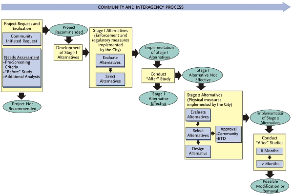
I was reading through the old Access Boston (2000-2010) website, which is still featured prominently on the City of Boston's transportation website. It's a fairly old document, but it doesn't seem like there's been any update in the past decade. Here's the process you need to go through in order to implement a proposed pedestrian safety improvement:


To begin, following a "Community Initiated Request" there must be a "pre-screening" and a "before" study:
The prescreening criteria include basic roadway characteristics that allow the BTD to determine if implementing transportation safety improvement measures are appropriate for residential streets. [...] First, the study will establish a traffic baseline from which the effectiveness of the project can be compared to later.  The second purpose is to collect data to perform a level of screening to ensure that it is still appropriate to consider transportation safety improvement measures.

Then BTD will consider some simple regulatory or sign changes, known as "Stage 1 alternatives." If that fails in the "after" study, then they will only consider physical changes for pedestrian safety if: (a) the road is under 40 feet wide, (b) not an emergency or bus route, (c) no more than one lane in each direction, (d) not too steep, and (e) not curved too much. There's more. For Stage 2 changes, a neighborhood organization must be formed to study the options. Ultimately, it suggests that a petition with 75% neighborhood support must be submitted, and it must also receive 100% of support from immediate abutters. And the City retains the right to refuse the proposal. And you must find funding through a source such as TEA-21, AAA, or squeezing it out of adjacent development projects. The Stage 2 modifications cannot cause adverse effects to neighboring roads, either.

Considering all that, I'm surprised that any of these pedestrian safety proposals were ever implemented.

Wednesday, April 4, 2012

Fare hikes, service cuts incoming

As expected, the MBTA board approved the revised plan today, despite the protests of assembled riders at the public meeting.
Director Ferdinand Alvaro, who was the only member to oppose the plan, said, “I cannot in good conscience support a budget that covers the gap and burdens the most vulnerable people in our population with covering the gap. It is time for the Legislature to come to the table.” 
Director Andrew Whittle said, “This is a hell of a way to run a railroad. ... I don’t think any of us are happy in this process.” 
But he noted that the Legislature had promised to address new revenues for transportation next year. “We’ve been told that if we act, the Legislature will act, and I think it’s important to hold them to it,” he told the packed room.
I frankly find this a bit puzzling. What motivation does the Legislature have to act in the near future, if the immediate threat of a budget apocalypse has been averted for another year? And it's not about finding "new revenues", it's about fixing the existing mechanisms, and shifting the Big Dig debt burden back where it belongs. I'd be curious to know who exactly gave that promise, and how credible it is. My feeling is that we're going to see the fare hike go into effect July 1st, and the Legislature will continue to pretend the problem doesn't exist, until we repeat the whole fiasco next year.

Monday, April 2, 2012

Attrition of automobiles / erosion of cities

Probably not what Jacobs had in mind (source)

Jacobs was far ahead of her time in writing that widening and building new roads instigates additional automobile traffic. This is an observation that had only begun to be discussed in the 60s, and people still have difficulty with it today. In 1962, Anthony Downs proposed "the fundamental law of highway congestion" which states that highway travel increases closely in proportion to highway construction. There is also a similar proposition called the Lewis-Mogridge Position. Recent work also explores this relationship in more depth.

Nowadays, responsible engineers and planners (ones not trying to profit from excessive concrete) understand this dilemma and in some places, have actually tried some different ways of fighting traffic that Jacobs would appreciate. But many people get confused when you discuss this issue with them for the first time. It is counterintuitive. Most people have experience driving on a highway that has one lane shutdown for some reason. They see the bottleneck created and exclaim that narrowing the highway permanently could only make things worse!

The confusion lies in the various different perspectives one can take on this problem. Most people are thinking in the immediate situation: the cars on the road are stuck because the highway is suddenly smaller than it was before. But that's not the perspective that road designers and city planners are supposed to take. They are supposed to think about how each road plays into the larger network of transportation, and the even larger world of development and land use, over the course of years. The construction (or removal) of highways and roads causes many people to re-evaluate their patterns of travel, their choices of residence, and how they go about getting around. It is this effect which causes observations like "fundamental law of highway congestion" to come true.

Let's look at an example: Boston's inner belt highway famously has no congestion. That's because Boston's inner belt highway doesn't exist. True, there are roads where the inner belt highway was planned, and they are often congested. But if the highway had been constructed, it too would have become congested in time, much like Rt 128 is today. And its construction would have ravaged a great swathe of land through Roxbury, Fenway/Kenmore, Brookline and Cambridge. In fact, the spot I am typing this from would have been badly affected, possibly destroyed. Thankfully, the residents of the time successfully opposed the highway. The ones that did get built have done a lot of damage, however. After all, we just spent $22 billion to bury one of the most infamous highway projects of all time. And one of the major unintended effects was to create even more congestion at the choke-points entering the city.

Fundamentally, congestion is going to happen around any attractive location, and there's almost nothing you can do about it. Automobile congestion springs up easily because cars are a particularly space-inefficient form of travel. If one person decides not to drive downtown, it is likely that somebody else is waiting to take up that space. And if more space is made available, then more drivers will take advantage of it. That's why public transportation doesn't cure congestion, and it is dishonest to claim it will. What public transportation can do is accommodate greater numbers of people than the roadways will permit. Although the congestion doesn't go away, the absolute number of people able to travel can go up, given appropriate transit options.

Only road pricing seems to have any effect on congestion. This shouldn't be too surprising to anyone who supports free markets, but many people go slightly insane when confronted with their addiction to Road Socialism. If a product is free or underpriced, then the supply becomes exhausted and queues form to obtain it. Most roads are free, or underpriced, so it is only natural that people form queues of traffic trying to use them. When road pricing is done right, it doesn't discourage travelers, it just sets a market incentive to use other modes of transportation when the roads become too busy. Sadly, it seems like it will be quite a long time before this reform is implemented around here, as it requires people to give up what many feel is an entitlement. If people could come to understand that "time is money" and either way, they're going to pay, then perhaps those stubborn impulses can be checked.

Sunday, April 1, 2012

A modest proposal for the MBTA

With the MBTA in dire budget shape, we need a solution to help the people in the Metro Boston area commute and get around. There have been several proposals to try and fix the budget deficit, including fare hikes, various kinds of service cuts, debt reassignment, union negotiation, and a litany of one-time options such as the excess winter snow removal funds. I have taken some time to think about this problem and I have come up with a simple proposal that could solve the MBTA's budget woes once and for all.

While browsing their website, I found the independent auditor's report, according to which, the MBTA has $8.2 billion in capital assets (after depreciation). This includes land, guide-ways, vehicles, and other assorted physical objects. All of this supports a system on which the number of trips reaches nearly 1.3 million per weekday. Assuming that's mostly commuters, it probably means there are approximately 550-600 thousand riders. This works out to approximately $13,500 to $15,000 per rider in capital assets. By comparison, the 2012 Ford Fiesta, one of the cheapest cars on the market, costs approximately $14,000.

The new Red Line
The proposal is simple: Sell off the capital assets of the MBTA and buy several hundred thousand Ford Fiestas. This will stimulate the economy by providing many jobs to build the cars, and by opening up much valuable downtown land for new small businesses. It's a win-win for the American and Boston economies. Just think of all the advantages for the individual rider: on-demand point-to-point service, no waiting, not getting stuck on yet another broken down train, and much faster too.

I'm sure somebody (who hates America) will raise some kind of objections to this plan: What about gasoline prices? Shouldn't we try to conserve oil? How will all these new cars fit on our roads and parking lots? As for gasoline prices, the MBTA currently receives an approximate $800 million/year subsidy. That could pay for approximately $1500/person in fuel costs. And conserving oil? Well, once we stop wasting so much oil on driving around empty buses, then we'll have tons leftover! Plus, I bet if we drilled underneath some existing T stations, we'd find lots of oil just waiting to be used. Drill here, drill now! After we're done drilling, we can convert all that leftover land into nice new highways and parking lots. Problem solved!

There'll be plenty of clear right-of-ways once we remove those pesky tracks

Plus, with all the new gasoline purchasers, there'll be plenty of fuel tax revenue to help clean up the pollution from the old MBTA sites, and think of all the money we'll save by not having to subsidize commuters anymore. That will solve our highway funding problem, and then we'll be able to afford more above-ground lanes to take the load off the Big Dig Central Artery tunnel, as shown in this rendering:

Imagine, no more sitting in underground traffic!

The next board of directors meeting is coming up this week, on April 4th. The current proposal from Richard Davey is just a temporary fix that will only provide enough funding for the upcoming year. Instead of revisiting this issue again next year, the board ought to consider this modest proposal as a permanent solution to the problems of the MBTA.

Wednesday, March 28, 2012

MBTA releases new proposal

Boston Globe article:
MBTA riders would pay an average of 23 percent more and most service cuts would be spared under a budget-balancing plan that will be announced this morning by the T, the state’s top transportation official said in an interview.
This would raise CharlieCard subway fares to $2 and eliminate a few bus routes along with weekend service to Heath St, Needham, Greenbush, and Kingston/Plymouth. It uses a lot of one-time opportunities, including leftover snow/ice removal money, and does nothing for the long-term problems of funding. Rather pathetic overall. They need to get the legislature motivated to fix forward funding, instead of kicking the can further down the road.

Monday, March 26, 2012

Is NextBus starting to fail in Boston?

This past month or so, I've started to notice that, from time to time, a bus will pass by without appearing on my NextBus GPS-tracking feed. At first it was just once in a while, enough to make you start wondering, but not terrible. Today, I spotted two buses that never appeared on the tracking. In addition, in the evening rush hour, the feed only showed buses arriving in 24 and 96 minutes -- this on a key route which runs every 10 minutes all day. Something weird is going on. I am presuming that the GPS units inside of the buses are failing in some fashion.

I haven't had an experience as bad as these ghost buses in D.C. with NextBus in Boston. Actually, the service has been pretty good so far. It's a little optimistic about the speed of MBTA buses, so sometimes that last "1 minute" takes longer than one minute. I hope that this is just a temporary glitch. The real-time data really changed the way I used public transportation, making it a lot more convenient, and a lot less stressful.


Friday, March 23, 2012

Public comment period ends for MBTA proposal

The MBTA has wrapped up their public campaign to collect comments about the proposed service changes and fare hikes. They have published some statistics and general information about the public input in a slideshow. The highlights slide says:

•More than half, 51%, of all comments are from bus customers.
•A much larger percentage of customers oppose service cuts (78%) compared with those customers opposing fare increases (24%).
•More than 10% of replies support fare increases described in our proposals.
•Nearly 60% of comments call for the MBTA to maintain bus services.
•More than one fifth (21%) of comments call for the MBTA to maintain commuter rail service.
•17% of comments ask the MBTA to maintain ferry service.
Judging from the tone of the slides, and the fact that Davey indicates that some new plan will be proposed by April 4th, I get the feeling that they are trying to rationalize some kind of fare increase come this summer. I am disappointed that they did not categorize any letters calling for a legislative fix to forward funding, or returning the Big Dig debt to the Commonwealth of Massachusetts where it rightfully belongs. The MBTA seems to have tunnel vision on this matter; considering only fare increases or service cuts, even though neither can lead to a permanent solution for the problems of funding.

Sunday, March 18, 2012

Traffic queuing

Longfellow Bridge plans

I often hear traffic engineers and other people talking about "queuing" in lanes lead up to intersections (for example, near the River Street bridge). It seems to them to be very important to have enough space for vehicles to wait as they transfer between roads. From my computer science perspective, I understand where they are coming from; I have a working familiarity with queueing theory and I am wary of deadlocks. But there is a significant difference between abstract mathematical notion of queues and the reality of human-driven automobile traffic on roads. The flows between roads aren't immutable, and there are a lot of subtle feedback effects which drive patterns of congestion: the very kind of behaviors which are not handled well by queueing theory.

Rose Kennedy Greenway
If I had magical powers, I would wave a wand and make congestion problems disappear for everyone (well, after curing cancer, etc). In reality, when people talk about relieving congestion, they generally mean "add a lane." Perhaps the one lane can only hold 25 vehicles while waiting at a light, and observations have shown that there are 30 vehicles waiting at worst during peak hours -- spilling and blocking the roadway behind them. So the natural suggestion is to add a lane and accommodate up to 50 vehicles. The problem is that with all this extra capacity, more people will make the decision to use the newly widened road for their trips. Also, clearing up the blocked traffic on the feeding road gives more vehicles the opportunity to make the turn. As a result, the newly widened roads ends up overflowing with 55 vehicles instead of 30. It's just another case of 'the fundamental law of highway congestion' which, in econ-speak says: elasticity of vehicle kilometers traveled to lane kilometers is close to 1. In normal person-speak, that means that car traffic almost always fills up available road space (see also: Downs-Thomson paradox).

Near Sullivan Square
Now if adding a lane actually worked, had low costs and little other impact, there would be hardly much more to say about this. But without a magic wand, that is not the case. Expanding roadways in urban neighborhoods causes direct harm to the inhabitants of that area. It is more difficult to walk across wider roadways, it is more dangerous to be around them, and there is more pollution from the added vehicles. So by choosing to widen a road, it is likely that you have failed to solve the congestion problem, and you've made life worse for residents and other people in the area.

Saturday, March 17, 2012

The rent is too damn high

I've finally gotten around to reading The Rent is Too Damn High by Matthew Yglesias and I think it is a fine long form article/e-book. It isn't going to be terribly novel to anyone who has been following these issues for a while, but it does put them together in a pretty coherent and easy form in his characteristic style. For those who don't know his writing, I will say that Yglesias has a knack for putting non-obvious ideas into terms that make you wonder why you didn't think of it that way before. He is not afraid to challenge orthodoxy on both sides of the political spectrum when it comes to cities and urban planning, and that alone makes it worthwhile to pick up and read, even if you do end up disagreeing with some of the specifics.

Since in the continuing series on Death and Life of Great American Cities we just covered the chapter on 'Self-destruction of diversity' I think it is relevant to talk about Yglesias' chapter on 'The Mirage of Gentrification' which is also the part of the e-book that I think is weakest.

He is correct to point out that higher land prices attract developers, and that it is perverse to try and keep prices low through neglect. He is also right to point out that the only way to bring down rents is to build more dwelling units. But I think he dismisses too quickly the problem of disrupting community ties and seems to presume that foes of gentrification are only interested in preserving 'neighborhood character.' It is true that some people do think that way, but there is a more subtle reason to be concerned about rapid changes and it is one that Jane Jacobs dwells upon extensively.

Now, regarding 'character' I'm going to go out on a limb and say "does it really matter?" It's a nice thing, and I certainly have my own preference for more traditional styles while despising Brutalism. But it doesn't ultimately matter (except that Brutalism is soul destroying). What does matter is people, and the relationships between people in the city that Jacobs so eloquently described. As an example: the infamous housing projects of mid-century have many problems. Everyone grimaces when I describe the characteristic Garden City-style towers and super-blocks. And those design choices were certainly bad and deadly to urban well-being. But the worst and most pernicious effect of the housing projects was the way they tore apart neighborhoods and displaced the diversity of people who lived in the old neighborhood, replacing them with a homogeneous economic strata, where people are merely measured by their wages and treated as so many interchangeable pieces.

Cities are about people, first and foremost. The smart opponents of gentrification shouldn't be aiming only to preserve 'character' or the profits of a specific set of business owners, though doing so in moderation is one possible strategy. They really should be trying to preserve the social networks between people that maintain the good workings of the neighborhood. These networks will slowly change over time as people come and go, and the neighborhood will change over time as people build or renovate their properties. But humans can adapt to that naturally. They cannot adapt to having their entire neighborhood be bulldozed and replaced by a centrally planned project. Nor can they adapt well when a developer bulldozes an entire block to build condos, or whatever happens to be the most profitable type of building at that moment in time. Or if rents rise so broadly that some critical number of people are displaced which causes a catastrophic breakdown of the relationships between the former residents.

Of course, as Yglesias points out, having developers build more housing units is the only way to ultimately lower rents. But how do you permit them to build more, and varied units to accommodate diverse lifestyles, while not displacing too many people too quickly? You face the threats of rising rents vs the threat of redevelopment, and the solution to one can exacerbate the other. Unfortunately, it doesn't appear that Yglesias considers the second problem in his analysis, nor does he mention the issue of promoting diversity of use.

In Jacobs' chapter on 'The self-destruction of diversity' she makes some very specific proposals to try and prevent districts from hollowing themselves out: zoning for diversity, staunchness of public buildings, and ultimately increasing the supply of vital city streets to meet demand. By 'zoning for diversity' she means some form of rules which permit change, but not overwhelmingly of one kind, not too quickly. This is fundamentally different from zoning as it is usually practiced, and perhaps makes it a misnomer. The 'staunchness of public buildings' is another form of this same principle, one where the city can simply choose to keep its working properties different from their surroundings by not selling them off. For example, the Massachusetts State House could have been sold for the development of more condos, but its presence keeps an additional kind of primary use around the Boston Common area, to the benefit of all. Admittedly, I find the notion of 'zoning for diversity' to be a tricky one to put into practice. The intention is clearly to help preserve the four properties of successful districts, and the social networks of people who are present there. But it seems liable to be abused in practice, or to be subject to problems of corruption, where a developer could claim they were "preserving diversity" when in effect they were doing the opposite. Yglesias and Jacobs do come together in agreement on the notion that the supply of good, vital city neighborhoods must be increased, somehow.

The main difference between the work of Yglesias and Jacobs can be summarized as thus: Yglesias is interested in increasing intensity of use, but doesn't dwell on the other three characteristics of successful districts. Actually, it is curious that he doesn't mention them at all, since he is clearly aware of her work. However, his basic argument is sound: that land use regulations must be relaxed to permit more free market use of land. This is something that needs to be more widely understood by just about everyone.
Friday, March 16, 2012

River Street bridge replacement


A bit over a year ago, back when winter still meant snow on the ground, I decided one day to take the River Street bridge on my way from Cambridge to Brighton. This bridge combines with the nearby Western Avenue bridge to form the primary link between these two neighborhoods across the Charles River. Both were built at the same time, approximately 80-90 years ago, and are considered "historic." On the Cambridge side, River Street intersects with the arterial road Memorial Drive. On the Brighton side it is Cambridge Street intersecting with Soldier's Field Road. When the Mass Pike extension was built to Allston, the entrance and exit ramps were built very close to the River Street bridge intersection. Although this corridor was the historical link between Cambridge and Brighton, at the time there was little thought given to pedestrian safety, as they did not expect people to ever walk here again.

Looking at Cambridge Street overpass from the River Street bridge

Bearing this in mind, I trudged across the bridge in the heavy snow and, dodging traffic from the highway ramp, managed to reach the foot of the Cambridge Street I-90 overpass. At this point, I was standing in snow up to my knees, realizing that this sidewalk would never be plowed. I wasn't even sure where it was, exactly. What's worse, is that I could not ascend the gradient in this weather, it was too slippery. Maybe, instead, I could climb up the little bit of 'greenspace' that formed a berm for the overpass. As I considered my options, suddenly, a passing car opened its window and the driver yelled out: "WHAT are you doing?!"

It dawned on me just how screwed up this situation was. Here I am, attempting to travel along a path that has existed since the 18th century, but because I am on foot, I am now out of place.

As it turns out, I am not the only one who felt this was wrong. MassDOT is proposing to rehabilitate the Western Avenue and River Street bridges that connect Brighton and Cambridge, as part of its Accelerated Bridge Program. They held their Allston/Brighton public meeting today. Much of what was said by the public officials is contained in the PDFs, as they mostly stood up and read from the slides (bad presentation skills!). One of the main points of their plan is to fix all of the pedestrian and bicycle safety infrastructure on and surrounding the bridges. During the public comment phase, many people stood up and expressed how grateful they were that MassDOT was making such a strong effort to accommodate all modes of travel in their plans.

The strongest criticism came from those who were disappointed that the agency had decided to forgo the inclusion of pedestrian tunnels for the Charles river pathways. It's a separate issue from the traffic above, but would require fill and therefore must be subject to a "historic landmark" review process and permitting. Similarly, several people were in favor of removing the overbearing concrete barriers that serve as a railing; but they too are protected as a "historic design feature" of the bridges, although their purpose is to block views of the river (which apparently was badly polluted back then). There were many other comments, some to do with the specifics of how light phases, or bicycle lanes were going to be designed. But overall, the impression I got is that MassDOT wants to do the right thing and make this combination of bridges be accessible to all whether they be driving, walking or bicycling.