Pages

Tuesday, February 4, 2014

Boston's narrow streets are safest for walking and riding a bike: wide streets are the most dangerous.

A wide street, Brighton Ave: 80 feet wide. Chung-Wei Yang was killed by a bus here.
I was reading an interesting Globe article on winter biking the other day when I spotted a sentence that was clearly tossed in there without much thought:
But urban biking does present risks, especially in Boston with its narrow streets and aggressive drivers. In 2012, five cyclists were killed in accidents — though none in winter.
This false, lazy sentiment about Boston's streets is unfortunately somewhat widespread. In fact, Boston doesn't really have many narrow streets. But, the narrow streets that Boston does have are one of its greatest advantages over other American cities.

In general, narrow streets are safer. From that study in Colorado:
“The most significant causal relationships to injury and accident were found to be street width and street curvature,” according to the report. “The analysis illustrates that as street width widens, accidents per mile per year increases exponentially, and that the safest residential street width is 24 feet (measured from curb face).”
Even 24 feet is fairly wide (enough for two fast-moving traffic lanes), but that town did not have any smaller streets to study. Even without the research, it's easy to see that the main purpose of wide roads is to make it easier to drive faster -- and speed is the biggest danger to life and limb. One of the reasons New York City is having so many problems with street injury is because, other than a few, relatively small areas of Manhattan and Brooklyn, that city is cursed with extremely wide streets.
Huntington Ave (courtesy: Google): about 95 feet wide. Kelsey Rennebohm was killed by a bus here.
Boston is luckier in that it escaped the foolish 19th century fad for wide streets with much less damage. The oft-noted "cattle paths" (not really) of downtown Boston are not so problematic. There are some cases where arrogant city planners from the twentieth century actually tore down buildings and parks to widen streets, and that was unfortunate. But luckily we managed to save most of Beacon Hill and the North End from their depredations and those neighborhoods survive as examples of people-scaled streets. We are also lucky that when the Back Bay was built, the streets were not created as big as New York's -- although they are still quite a bit larger than they should be, and in some cases, quite dangerous.
Beacon St and Charlesgate West: at least 100 feet wide. Kanako Miura was killed by a dump truck here.
But Boston's narrow streets pretty much end after you leave the downtown area, Beacon Hill, and the North End. Outside of that scope, Boston has many wide streets, and many streets that are much wider than they ought to be. While many of the residential side streets are 24-30 feet wide, I still see many drivers using them as high speed cut-through routes. But the truly dangerous streets are the main ones, which around me range from 50 feet, to 80 feet, up to even 170 feet from sidewalk to sidewalk.

Comm Ave at St Paul St (courtesy: Google): about 110 feet wide. Chris Weigl was killed by a tractor trailer here.
This is where the perversity of the Globe article quote comes into play: all of the people who were killed while riding their bike in 2012 were killed on very wide streets. Yet, the author blames "narrow streets." With such misinformation flying around, is it any wonder when people don't know better? Wide streets continue to be designed and built, on the premise that they are safer, when nothing could be further from the truth! One time, I asked an architect about why he was creating a new street that was so wide, next to a park where children play. He told me: but that's how it is in the South End, where I live! He didn't stop to think that the South End's wide streets were a danger and a drawback to living there.

Here's some more data. BPD identified several intersections which had the most crashes involving a bicyclist in 2012:

From Cyclist Safety Report 2013: most problematic intersections
Here are the street widths:

  • Beacon St at Massachusetts Ave: 50 feet
  • Massachusetts Ave at Beacon St/Comm Ave: 60 feet
  • Harvard Ave at Brighton Ave: 50 feet
  • Brighton Ave at Harvard Ave: 80 feet
  • Comm Ave at Harvard Ave: 160 feet
  • Huntington Ave at Belvedere St: 95 feet
  • Belvedere St at Huntington Ave: 60 feet
  • Columbus Ave at Cedar St: 70 feet
  • Cedar St at Columbus Ave: 26 feet
All of those streets are very wide except for Cedar St; a small side street that is one of the only ways to walk or bike between two densely populated residential sections of Roxbury, and requires crossing the very dangerous Columbus Ave between two very long blocks.

Columbus Ave (courtesy: Google): about 65 feet wide. A woman was struck and killed here on Christmas Eve.
I could keep going on and on, but I think I've made my point quite clear: wide streets are dangerous. Unfortunately, Boston has many wide streets, and it is very difficult to fix them once they are created. The best way to create safer streets is to build them narrower from the beginning. But in the rare cases where we have that opportunity, we are still building wide streets because people do not know or understand the danger. Engineers claim to try and anticipate future traffic growth, and they do not consider the costs of the wider streets at all. Fire marshals want wider streets and turning radii for their trucks, but they don't think about the people who will be killed or injured by those design choices. Architects like wide streets because it feeds their egos: they're always trying to build the next "grand Parisian boulevard" and, at least in the bad old days, they could care less about the human cost. Even the new planners, with their "complete streets", tend to favor wider streets: to squeeze more stuff onto. That is unfortunate. Complete streets should be seen as a way to reduce the danger of overly wide streets, not as an excuse to make the mistake of building wider streets from the start.

If we want streets to be safer in the future, what we really need is a program which encourages narrow, human-scaled streets, and also celebrates the narrow streets that we have inherited from the past.

Saturday, January 25, 2014

weMove Massachusetts: A disappointing, flawed plan for performance metrics that will repeat the mistakes of the past


This month, MassDOT announced a new plan called "weMove Massachusetts" which introduces the idea of using performance metrics to help plan investment in transportation. Sounds good, right? I was looking forward to reading about a scientific approach towards selecting projects that help people access the opportunities in their lives, while steering towards overall goals like "GreenDOT." But instead of that, when I read the report, I found the same bad old attitude that you also find at the Texas Transportation Institute. The main automobile measure is regressive. The sole metric for bicycle usage is almost completely useless. The transit metrics range from irrelevant, to poorly designed, down to outright worthless. There are no walking metrics in the report. Many of the metrics don't even involve actually measuring anything in the real world!

Metrics have consequences

Before I go into the specifics, let's take a quick step back and think about what we actually want out of our transportation metrics. There are two main ways of looking at transportation broadly, and both have their uses, depending on context: mobility vs accessibility.

Mobility measures the amount of traveling you are able to do: e.g.

  • How fast can you go?
  • How far can you go?
  • How easy is it to move around?

Accessibility measures the amount of opportunity that is open to you because of transportation: e.g.

  • How many jobs/needs/activities can you reach in a reasonable amount of time?
  • How many choices do you have about getting to your destinations?
  • How is your quality of life improved by transportation?

These are not completely distinct viewpoints. For example, you could increase the number of jobs available to you by improving the speed of transportation. On the other hand, you could also achieve the same by having the economy add more jobs within your existing range, or by moving to a region with more job density. The latter is, broadly and superficially, the way cities form.

However, choice of viewpoints does matter when trying to put together cost/benefit analysis for new transportation projects, and it is very important to choose carefully. A metric is a convenient number which tells you something useful, but it is also an intentional oversimplification which can lead you astray if not used judiciously. Unfortunately, our MPO has a history of abusing metrics, and traffic engineers are infamous for applying the wrong tools to our cities, causing terrible destruction in the process.

Is there an ideal general metric at all? I don't think so, but the closest one I believe is the last example I cited above: "How is your quality of life improved by transportation?" Ultimately, transportation is about giving you the ability to live your life as you see fit, to take advantage of the opportunities open to you, and to keep you safe while doing it. The problem with this formulation is that it is very vague and broad, making it difficult to quantify. That's intentional: "quality of life" means as many different things as there are different people, so there really is no one way to interpret this. Instead, when designing performance metrics that are more easily quantifiable, this principle is what you should be striving to justify your decisions by: how does your work help people live the life that they want to live?

Without further ado, I will jump into the "weMove Massachusetts" report and its many flaws:

Pavement, Bridges


I've grouped these two together because they have a similarity: obviously you don't want roads to crumble or bridges to collapse. But, the metrics assume that the status quo is sustainable and desirable, and all that is needed is an influx of money to repair what we have. A very, very large influx of money: $544 million a year on Pavement and $447 million a year on Bridges. That's a billion dollars a year for what will basically only benefit motor vehicle modes. This is not to deny the need for such repairs or such infrastructure. We need some of it. But do we need ALL of it? There should be some cost/benefit analysis applied to the two largest line items in the transportation budget. These metrics do not enable that. There is no consideration given to whether a lane diet might be a better way to go, for safety and money-saving purposes. And there is no consideration given to whether an overpass should be removed instead of rebuilt, even though 1950s traffic levels on it long ago disappeared. Is every square inch of asphalt sacred? Must we continue to perpetuate the mistakes of our forebears, at any cost, without thought?

Mobility


This metric is one of the worst in the document. It's basically lifted straight from the highway-crazed Texas Transportation Institute. Sure, this metric is fairly easy to quantify, but it reduces the whole notion of "mobility" down to one, highly confounded number: hours of delay per 1,000 miles traveled in a private vehicle. To understand why this is a bad metric, even from a driver's standpoint, consider the following tale of two commuters, Alice and Bob:
Alice lives in Waltham and works at an office near Rt 128 in Waltham, about 2 miles away. Under ideal conditions, her commute travel time is 5 minutes by car. However, under typically congested circumstances, it usually takes her about 10 minutes by car.
Bob lives in West Stockbridge and works at a shop in Westfield, about 40 miles away. Thanks to the sparse population, Bob can almost always drive 60 mph from start to finish, for a commute travel time of 40 minutes each way.
I cannot speak for the relative happiness of Alice and Bob, since it would depend on their (fictional) personalities. However, I can point out that Alice only spends 20 minutes a day commuting, while Bob spends 80 minutes a day just getting between home and work. Yet, according to this "mobility" metric of MassDOT, Alice is suffering terribly from delays, while Bob is doing great. Assuming 250 working days per year, Alice puts in 1,000 VMT/year for her commute, and experiences "delay" of 41.6 hours/year.

Viewed through the prism of this mobility metric, the DOT would rate Alice's commuting experience as being miserable, slow, and hellish. But that doesn't make sense from a common sense perspective. Alice only has a 10 minute commute! I bet most people would love to be in her situation, rather than being stuck in a car slogging it out 40 minutes each way. The DOT's metric is completely at odds with the principle of "improving quality of life." Not only that, the metric completely ignores all other modes of transportation. Two miles is not that far. That could even be walkable on a daily basis. It's easily bikeable within 15 minutes. If Alice is the sort of person who values getting exercise to and from work, it could easily be made possible. Or perhaps she would rather take a bus, the 70A, and do some reading on the 15 minute trip. Bob has none of those options: he is a captive car commuter. The only option he has is to car pool with someone else. But the metric doesn't even care about that: since it measures vehicle-delay rather than person-delay, your passengers may as well not exist.

The story of Alice and Bob is a bit too neat, obviously: in the real world, there are many other factors. But it's meant to illustrate a point: the mobility metric chosen by MassDOT is aimed in the wrong direction. The metric of "delay per vehicle-mile" is not designed to produce good transportation outcomes for people, but rather, to produce more funding for expensive road-widening projects which line the pockets of connected contractors and please the egos of highway engineers. The footnote to this metric tells it all:
Funding for mobility projects includes any projects that will increase roadway system capacity such as additional lanes, bottleneck removal, intersection improvements, etc.
MassDOT will claim that Alice is "suffering" from tremendous delay as justification for widening the streets in her neighborhood, installation of fancy traffic engineering techniques such as grade separation and complicated traffic signal phases. All of which will degrade the quality of life in her neighborhood. To be fair, in this day and age most of that will be shouted down by commuter opposition, but this is the same kind of metric that was used to shove these kinds of "improvements" down the throats of our communities in the past. More insidiously, planners will use this delay metric as justification for furthering suburban sprawl, instead of creating compact, walkable neighborhoods. The "delay per vehicle-mile" metric is complete garbage and thoroughly inappropriate for an agency which claims to be about promoting "smart growth" and "green travel" mode shift.

Safety


Safety is important. Everyone knows that. But, this particular way of doing it is an example of a metric which sounds good at first, but is actually quite mediocre, or downright dangerous, when you look at the details of how it is actually implemented. Why is there a focus only on intersections and interchanges. That seems strange. Although those are certainly higher risk locations, crashes can happen at any place. Why the restriction? The answer is found in another section which fills in some of the details:
Roadway safety is typically measured by the number of crashes. Crash rates cannot be easily projected into the future using the types of performance curves applied to other highway metrics. Therefore, safety performance was measured by the number of high-crash locations that can be improved over time for an average cost of $500,000/intersection.
So basically, they claim that they cannot get a good metric for "crashes prevented per dollar" and therefore, as a proxy, they will just count the number of intersection projects that can be funded, assuming half-million dollars each. Here's a litany of problems with this approach:

  1. There's nothing about "intersection improvements" which necessarily implies better safety.
  2. DOTs have a history of making "improvements" that make streets more dangerous for walking and biking. For example, street widening is sometimes considered a "safety improvement" even though it will end up producing more injuries, particularly to vulnerable road users.
  3. The real danger to safety comes from speeding vehicles. Again, "intersection improvements" says nothing about this, and the metric is completely mum about speeding elsewhere on the street.
  4. The metric encourages spending money on intersections and interchanges, but it does not actually measure whether that money was spent in a worthwhile way.
  5. It assumes that spending a half-million dollars is all that you need to do to "fix" an intersection.
  6. Severity of crashes is not considered at all. If you had to pick a design based on safety consequences, which would you select? (a) One person will die each year in a severe crash, or (b) ten people will be slightly injured a year in minor crashes. Obviously, zero injuries or deaths is best, but if you had to choose, then I think that (b) is a much better outcome. The metric considers none of that.
If you are going to adopt performance metrics, then you should actually go out and measure something in the real world. This so-called "safety metric" does not do that: instead it simply divides the amount of money available by the number of intersections, and calls it a day.

Bicycling

Behold, the only bicycle-focused metric in the entire report. The main mobility metric only focuses on cars, so this one should partially make up for that, right? Right? Yeah right. This metric is the first one in the report where you start to think that this whole document is really just a long, boring joke. If you try to consider it, there are a variety of ways you might go about quantifying bicycle performance (not endorsing any particular one): bicycle-miles traveled, % mode share bicycling, % population that owns a bicycle, % population that considers bicycling, number of comments on the Internet complaining about bicyclists, etc. What all these metrics have in common is that they involve making measurements in the real world: something must actually be counted, a number that cannot simply be conjured out of thin air.

This is in stark contrast to the proposed MassDOT metric: completion % of the Bay State Greenway, a network of off-street cycle paths. The DOT's metric is computed by looking at the budget documents and comparing whether or not the Bay State Greenway is funded under both budget scenarios. Since it is, the metric is set at 0% from now until the end of time. The genius who put this one together probably thought he or she was pretty clever to insert a "performance metric" which required a grand total of 30 seconds of work behind a desk, and will never need to be revisited again.

Complete and utter failure. Secretary Davey, this is a disgrace.

Walking

Just kidding. There are no walking metrics in the report. Well, I suppose you could pray that the "Safety" metric will bring "intersection improvements" that actually benefit pedestrians, and that the "Mobility" metric does not end up destroying the walkability of streets which used to be safe before the traffic engineers got their hands on them.

Transit

The tone of the report changes once it reaches the transit metrics. Prior to this, the metrics were somewhat broad or simplistic, but the transit metrics are very precisely chosen. Unfortunately, they are chosen rather poorly for planning purposes. I was told by some MPO staff that the MBTA was responsible for their metrics, and that does seem to be the case because these metrics are largely only of interest to someone working in the T's maintenance department. Since there are so many, I will group a bunch together and address them at once:
  • MBTA Bridge condition: the % of bridges that are in state of good repair.
  • MBTA Elevator/Escalator condition: the % of elevators/escalators that are in state of good repair.
  • MBTA Station Accessibility: the % of stations that comply with the Americans with Disabilities Act and the MA Architectural Access Board standards.
  • MBTA/RTA Bus and Train performance: the % of vehicles in state of good repair.
  • MBTA Signal performance: the number of annual signal failures.
All of these metrics are important -- to the people in charge of maintaining the system. However, these metrics are fairly irrelevant to the average customer. Reliability is important to the customer, certainly, but we don't go through the trouble of providing public transportation because we really like to do bridge or signal maintenance: the purpose, the reason for existence of the system, is making transportation available to people. People want to know that when they show up at a train or bus station, a vehicle will arrive in a reasonable amount of time. They want a system which gets them where they need to go, which gives them access to the city region and all of the opportunities contained within. Specific "state of good repair" statistics are part of the internal implementation of reliability. I suppose it's fair enough that they are being open about it and including it in the report. Fine. But then, where are the metrics which actually measure what people want out of a public transportation system? Not present in this report. Maybe the closest is another maintenance statistic:
Again, we have a performance metric based on delay, like what cars get. Good? Not quite. One improvement is, at least in this case, positive values don't imply a need for highly destructive road widening, since that is not on the table. So, improvements to delay are probably all upside, no downside other than cost. What else could be wrong? Well, it's another case of the same disease which seems to periodically infect planning at the Boston MPO and the DOT: vehicle-itis, the curious syndrome in which transportation agencies forget that their job is to help human beings, and instead focus entirely on pieces of steel and fiberglass.

This metric, like the mobility metric before, only focuses on the delay to vehicles, rather than people! In the other case, you might shrug it off because the average car only carries a few people at a time (although that attitude still screws over carpools). But it is huge loss when you neglect to account for the fact that a train could easily be carrying over five hundred people who are all delayed when the vehicle is delayed. The next time the Red Line breaks down, think about this: the MBTA, MassDOT, and the Boston MPO have all committed to the belief that your time, as a transit rider, is only worth 1/500th the value of anyone who happens to drive alone in their car.

A lot of perversity about our transportation system can likely be explained by this attitude:
  • The ever-increasing insertion of delays into the routine of T travel. From completely pointless, customer-loathing tactics like "Front Door Only alighting," to random "safety stops in the middle of tunnels" that are never fixed, to schedule management that hasn't changed since the early 20th century, to deferred maintenance up the wazoo, it's all part of a culture of not caring about the riders on-board the vehicles.
  • The continuing refusal to use signal priority for transit vehicles on the surface. Both Beacon St and Huntington Ave have the technology installed to do it. But the MBTA can't be bothered to implement this modern technique which is used all over the country and the world. In their eyes, a train with 300 people on board is not worthy of causing ten seconds of delay to a precious private automobile.
  • An almost complete lack of bus lanes outside of the gimmick lanes on Washington St -- which don't extend into the part of the city where bus lanes are desperately needed. This one's on BTD as well, but the MBTA should be pushing hard to improve the ridiculously slow speed of its buses.
  • The achingly slow turnaround time on the barest of improvements. The key bus route improvement project took about three years. Not because it was hard (it's not). Not because it was expensive (it wasn't). But because nothing happened for two years and then finally bus stops started getting moved, and painted in the street, within a few months at the end of last year.
  • The truly pathetic state of some of the stations, particularly on the surface, where there's nothing more than a few feet of asphalt with cars zooming by, inches from your body. And that's on a section of roadway that was rebuilt relatively recently!
  • The fingernail-pulling it takes to get sidewalks, crosswalks and bus stops shoveled clear of snow around here.
Choosing good metrics for transit is not easy, as it depends on the context and what you are trying to accomplish. But you cannot reasonably plan a transit system without using metrics which count people. Some examples of useful mobility-style metrics might include, but are not limited to: boardings per mile, net cost per passenger, average passenger load, or number of people unable to board vehicle due to crowding. Some examples of useful accessibility-style metrics are: number of jobs available within a 30 minute transit trip, number of people within a 5 minute walk of a frequent transit stop, number of people with disabilities who successfully navigate your fixed-route system, or percentage of riders who claim [dis]satisfaction with the transit system.

Conclusion

I know that I have been a bit crass about the problem here, but it is only because a strong tone is necessary. The "weMove Massachusetts" plan is terrifyingly terrible. It represents a large step backwards, encoding 1950s-style thinking about highways into a document which pays lip service to "smart growth" and "green travel" but does nothing to promote either. It is so bad, that I can only recommend one course of action: rip up the "weMove Massachusetts" document and start over from scratch. This time, choose empirical metrics which require real-world measurements, categorize them under either "mobility" or "accessibility," and justify why the people of Massachusetts should care about the metrics. I propose that the guiding principle be: "transportation investments that improve the quality of life of people in the Commonwealth" but I am open to suggestions.

I also want to add a note about GreenDOT: supposedly, it is a goal of MassDOT to triple the mode share of walking, bicycling, and taking public transportation. This report talked about that goal but, like with many other things, did not really go into any significant detail about it. However, I did hear from MPO staffers that the metric used will be "person-miles" for each of the "green modes." In other words, the Commonwealth of Massachusetts will either seek to encourage three times as many people to walk, bike, and ride transit; or, the Commonwealth will seek to force all current walkers, bikers and transit-riders to travel three times as far as they do today. According to the metric, either one works. Okay, that sounds a bit ridiculous, but that's because "person-miles" is not a good metric for walking, biking or public transportation in cities. If you want more details, read those links, but suffice to say: there's no public good served by forcing people to walk, bike or ride buses further and further away. Distance is not a virtue in itself.

I just wish that the people who put together metrics at our departments of transportation, and our organizations of planning, would put in even an ounce of thought into their work.

For more reading on metrics, and mobility vs accessibility, I recommend this paper by Todd Litman.

Monday, January 20, 2014

The term "jaywalker" is a slur

Excerpts from Peter Norton's book, "Fighting Traffic:"
When motorists first intruded upon city streets, annoyed pedestrians found epithets for the more aggressive ones. Some called them "joy riders," others "speed maniacs." Both terms connoted irresponsibility and a reckless disregard for the rights and safety of other street users. In 1909, for example, joy riders were motorists who abused their "power of life and death" over rightful but weaker occupants of streets: "pedestrians, ... the aged and inform, ... children playing in the streets"; in 1912 they were "automobilists" whose "aggressions" intruded upon the rights of pedestrians "to the very great danger of children and aged people." Both views reflected the unspoken assumptions of their time: that people on foot, including children at play, had a rightful claim to street space. 
Motorists replied with epithets of their own. They hit upon the most effective one early: "jaywalker." A "jay" was a hayseed, out of place in the city; a jaywalker was someone who did not know how to walk in a city. Originally the term applied as much or more to pedestrians who obstructed the path of other pedestrians---by failing, for example, to keep to the right on the sidewalk. As autos grew common on city streets, jaywalkers were more often pedestrians oblivious to the danger of city motor traffic. According to one early, more general definition (1913), jaywalkers were "men so accustomed to cutting across fields and village lots that they zigzag across city streets, scorning to keep to the crossings, ignoring their own safety" and "impeding traffic." 
Overworked police "cornermen" soon applied the term to pedestrians who ignored their directions. By 1916, "jaywalker" was a feature of "police parlance." Police use modified the word's meaning and sparked controversy. "Jaywalker" carried the sting of ridicule, and many objected to branding independent-minded pedestrians with the term. In 1915 New York's police commissioner, Arthur Woods, attempted to use it to describe anyone who crossed the street at mid-block. The New York Times objected, calling the word "highly opprobrious" and "a truly shocking name." Any attempt to arrest pedestrians would be "silly and intolerable."
Fast-forward one hundred years. Yesterday, an elderly Asian man was brutally attacked by NYPD officers. The reason? "Jaywalking." Earlier the same day, in the same vicinity, one pedestrian had been slain after being tossed by an ambulance into the path of an SUV, and another person was killed by a tour bus. The previous week, a taxi driver killed a 9 year old boy who was walking with his father in the crosswalk. No charges were filed against drivers in any of the cases.

NYPD bloodily beats an 84-year old man for crossing the street. (source: G.N. Miller/NY Post)
Prior to the 1920s, it was generally held that the public streets were public spaces, and that all people had a customary and ancient right to use them, with or without a vehicle. Terms like "jaywalker" were slurs invented by people expressing a crude emotional state, but it was not yet an epithet enshrined in law. During and after the 1920s, due to the lobbying efforts of organized automobile groups, the public figures became more comfortable with invoking slurs such as "jaywalker" in a more formal setting. This effort to redefine streets as a place only for cars, led by groups promoting the automobile, was followed by decades of declining freedom for children, pedestrians and other non-motorized users of the street.

In recent decades, efforts to reclaim freedom of the city street for pedestrians have boiled up in a number of cities around the country. But the old laws are still on the books, the laws that use slurs like "jaywalker" and which confine the pedestrian to tiny pieces of the public right of way, with limited mobility, facing danger on all sides. In proper, walking cities like Boston and New York, those old regulations have generally been held to be relics of the bad old days, mere curiosities, detritus. Only uncouth, unwalkable places such as Los Angeles, or most of Florida, would actually discriminate against pedestrians like so.

Alas, the old regulations do still have bite, especially when combined with the unaccountable, irresponsible arrogance of a police force such as NYPD. Although I have more faith in BPD than NYPD, the events of this weekend can show how rapidly things can turn for the worse, even in the strong walking culture of an Northeastern city. It is time to remove all laws and regulations on the books which discriminate against pedestrians, and it is long past time for slurs such as "jaywalker" to be deemed unacceptable jargon for use in formal, legal documents or pronouncements by public figures.

For Massachusetts, it could be relatively simple, since most of the anti-pedestrian language is found in the Code of Massachusetts Regulations, which are rules created by administrative department under a general authority granted by the legislature. In this case, it is 720 CMR 9.09, which, thankfully, actually refrains from using the term "jaywalker" itself. However, the existing code was written with the primary goal of speeding up cars and trucks traveling along streets, and segregates pedestrians in order to get them out of the way. The code was written at a time when the pedestrian was considered an obstacle, and a barely tolerated user of the street. The regulations should be reformed to put the safety of the pedestrian first and foremost, while preserving the traditional right of access to the public right-of-way that is entitled to every person. The upshot will be primarily one of calming streets, slowing traffic to reasonable speeds in city neighborhoods, and creating a much more relaxed, freer environment where drivers and pedestrians can share the use of our public streets.

This kind of environment was, actually, the direction that motor vehicle regulation had been headed in the 1920s: before automobile groups prevailed over safety councils in the halls of power. There are many quotes in Norton's book like this one:
Police and judicial authorities recognized pedestrians' traditional rights to the streets. "The streets of Chicago belong to the city," one judge explained, "not to the automobilists." Some even defended children's right to the roadway. Instead of urging parents to keep their children out of the streets, a Philadelphia judge attacked motorists for usurping children's rights to them. He lectured drivers in his courtroom. "It won't be long before children won't have any rights to the streets at all," he complained. As the usurper, the motorist, not the child, should be restricted: "Something drastic must be done to end this menace to pedestrians and to children in particular."
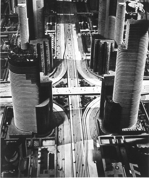
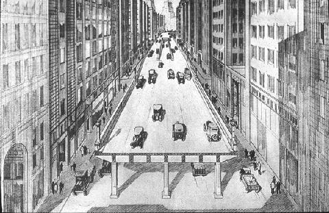
By 1930, the motoring enthusiasts succeeded in enshrining "speed" as the foremost goal of street regulation, and placated safety advocates by suggesting a system of grade-separated highways and elevated pedestrian sidewalks which would entirely segregate cars from walkers (and bikers). After nearly nine decades of experience, and millions of deaths, we know that the realities of such fantasies are horrific for pedestrians and the city, to the point where several decades and untold billions of dollars have been spent ripping down the elevated freeways that were built.
Futurama exhibit at 1939 World's Fair ("City of 1960!") by Normal Bel Geddes

Artist's conception of elevated highway in Boston, 1930 (source)

Reality of the Central Artery (source)

It seems to me that if we are repeating the struggle of the 1920s between motoring interests and city interests, then we should take heed of the lessons of the twentieth century. Grade separation does not work for city streets. The promotion of vehicle speed, over the safety and access of pedestrians, only leads to desolation and abandonment of the city. The police cannot be trusted to judiciously apply "pedestrian law" and it doesn't make sense anyway: nobody was ever killed by a speeding pedestrian.

The more appropriate path is the one that was unwisely abandoned in the 1920s: the recognition that on city streets, speed is anathema to safety. Socially, many people are coming to realize that the old way is the best way forward: the proliferation of safe street, complete street, livable street movements is testament to that. However, the law still enshrines the dangerous twentieth century dalliance with speed at the expense of safety, and the slur "jaywalker" is still considered valid jargon for use by public figures. It may be the only such slur. Changes in concrete take time, but changes in terminology need not.

Police resources should not be used as a weapon against walking. For one thing, it strikes at the heart of the city, which is the vitality of its walking population. For another, pedestrians have enough danger to contend with already: protecting themselves from heedless motor vehicle drivers who cannot be bothered to respect even the little scraps of street space the law grants to people on foot. Deploying police action against pedestrians is radically unjust, and an all too tempting case for abuse, as the NYPD demonstrated yesterday. After all, catching pedestrians is a lot easier than catching speeding motorists, because pedestrians pose no threat to anyone's safety. The penalty for misjudging the speed of a vehicle is already quite steep---injury or death---and a citation is simply heaping insult on top of that. On the other hand, everyone knows that the vast majority of reckless driving goes unpunished, and the penalty relatively toothless in comparison with the potential devastation wreaked.

Boston, in particular, has a major difference from many other counterpart cities: the extensive usage of "beg buttons" and the very poor programming of pedestrian signals and infrastructure. The status of Boston as a "walking city" is despite the infrastructure: because people have learned to routinely dismiss the signals as untrustworthy. Even BTD Commissioner Jim Gillooly has admitted that he does not really expect pedestrians to wait for the signal, and he personally does not either. So, Boston's status as a good walking city is largely dependent upon the choice of the powers-that-be not to enforce the anti-pedestrian regulations on the books.

New Mayor Marty Walsh has had a mixed record in his former job, the state legislature. While he has promoted bills which would reduce speed limits in urban areas, he has also pushed for doubling of penalties upon pedestrians, quite a regressive measure. Going forward, I hope that he chooses to distinguish himself from Mayor Bill de Blasio, by choosing methods of bringing safety to our streets that do not include pedestrian discrimination: walking should not be a crime, and making it so will only lead to conflict and disaster.

Saturday, January 18, 2014

Walk audit of Union Square, Allston and suggestions for the future

Union Square, Allston. The view from the Twin Donuts shop, facing east.

(Updates in bold posted 12th November 2015).

Let's take a look at Union Square in Allston, a vibrant neighborhood of the city of Boston. This is the convergence of several busy streets, a transit hub for buses, a retail district, with an elementary school and plenty of nearby residents living within a few minutes walk. I will call this a kind of "audit" because it is based on my observations, as an outsider. The audit uses timings from a weekend study. The main difference between a weekend and a weekday here is length of the full cycle: 90 seconds on the weekend, 110 on the weekday. Adjust accordingly.

Union Square, landmarks and street names. All satellite imagery courtesy Google.
Click on it for larger view.
Key points from below the jump:
  • The "level of service" given to the Union Square intersection, by the New Balance transportation study, is "D" (35s to 55s average delay/vehicle) during weekday a.m. peak and "E" (55s to 80s delay/vehicle) during p.m. peak and Saturday peak. "D" is considered normal in cities.
  • Traffic levels have declined by about 5-6% here since 2002.
  • An examination of the signal schematic (below) shows that for cars, no direction of travel has to wait more than 72 seconds to be given a green phase, on a weekend.
  • Yet, the minimum time for a pedestrian to cross Union Square (north/south), legally, is about 100 seconds, if you happen to arrive at the intersection at the optimal moment in the cycle.
  • For the less lucky, the expected crossing time is about 145 seconds with a worst case of about 190 seconds.
  • For the less capable walkers, the worst case is about 258 seconds. If you happen to be elderly, or a young child. the city expects you to wait 4.3 minutes to cross 95 feet. That's a rate of 0.25 mph.
  • The green right turn arrow given to traffic moving eastbound from Cambridge Street is in direct conflict with a walk signal for people crossing between the school and the fire dept station (see picture below).
  • The 21 seconds of walk phase given to the 110' crosswalk of Cambridge Street between the Jackson Mann school and Twin Donuts is not enough time for a healthy adult, much less a person with disabilities or a child going to the school.
  • There is no crosswalk marked at the Hano Street bus stop, despite heavy ridership. Instead, the city put up a new sign telling pedestrians not to cross there, in response to a tragic crash.
  • In the long-term, a Poynton-style redesign should be seriously considered, with a shared space design such as a single-lane roundabout (or similar) completely replacing the traffic signal-controlled intersection. All users of the intersection would benefit, as would the surrounding neighborhood.


Wednesday, January 15, 2014

Follow up to Jan 14th public meeting about Cambridge Street overpass


Yesterday was the third and, we believe, final public hearing about the Cambridge Street overpass repair project (MassDOT #606376). I would estimate that close to a hundred people showed up to hear about some major changes were made after the second meeting back on Nov 19. The Boston Globe summarized some of the changes, also shown in this cross-section:


MassDOT engineers decided to create the crosswalk at Mansfield Street but in order to build the accessible ramps, they realized that the bike lane would need to be raised onto the sidewalk. So they decided to create what may become Boston's first sidewalk level cycle track. I believe that the crosswalk and the cycle track are both positive changes, but there still remain issues to be addressed. Many of them were covered by people who spoke up at the public meeting, for a solid two-and-a-half hours of testimony:


  • The fence in the median is bad, unsafe, and ugly, and it must go. People want to cross the street, and will do so anyway by skirting the fence, but less safely than they do now. Plus, crossing at Linden Street is not illegal, therefore the fence is blocking a legal movement in favor of an illegal movement: speeding. MassDOT: we think our current design is safer.
  • 99% of 30 mph streets do not have a fence down the middle. Fences will inspire speeding.
  • We love the crosswalk. Can a temporary one be installed as soon as possible? We don't want to have to wait until 2017 to have a crosswalk there. MassDOT: difficult because of bridge joint.
  • The cycle track is a great step forward, but it changes the worry from car-on-bike to the possibility that there might be too much contention between pedestrians and cyclists.
  • The shoulders are now 3' wide in the new design. Could some of that space be reallocated to the sidewalk so that pedestrians have more space? Wide shoulders encourage speeding. MassDOT: we want that for breakdown space.
  • Revisit the shoulders, narrow the lanes, find more space for pedestrians. The outer lane feels like it is effectively 14' which promotes speeding.
  • The new lanes are 11' but on the River Street bridge you have small shoulders and only 10.5' lanes. Why not here? Wide lanes encourage speeding. MassDOT: we obtained exceptions for River Street bridge and don't want to do that here since there is room.
  • Speed is the main issue on this street: how do we bring it down to 25-30 mph?
  • There is a street light that juts into the cycle track every 100'. Can that be avoided? MassDOT: light poles must be outside of crash barrier.
  • The Lincoln Street intersection has a bike box in the new design, but it seems to be awkward and unlikely to be used. That intersection is barely functional for pedestrians and needs to be fixed. BTD: will take a look.
  • How will you prevent moped riders from using the cycle track?
  • Will you ensure that no gray boxes or other typical obstructions block up the sidewalk?
  • Cambridge Street shouldn't be a barrier for the community.
  • If you're going to put a fence, can you open up the Allston "subway" under the Pike, at least?
  • Expect 2-way travel on both cycle tracks, because of limited opportunities to cross the street.
  • MassDOT claims that the Franklin Street footbridge is going to be redone starting in about 3 years.
  • A bunch of trees were cut down from the embankment. Will they be replaced?
  • We need a snow clearing plan for sidewalk level cycletracks (and sidewalks).
  • The city intersections at either end of the scope need to be fixed -- ASAP.
  • How often are vehicles disabled? Does it really justify a 3' shoulder when most of the time it's not going to be used?
  • Hold off on the fence until after complete, then do a study to see if it is really necessary.
  • Will MassDOT promise not to use this "repair project" as an excuse not to redo the entire overpass if the $250m Mass Pike Interchange Improvement project decides that is necessary?
  • MassDOT: commits to study replacement of entire overpass as part of larger project, and will not use anything on this project as a hindrance to rebuild.
  • Will the crosswalk really work when traffic is going 40-50 mph? MassDOT: claims that new crosswalk strobe lights are studied and certified by FHWA for this purpose.
  • Business owner has seen numerous crashes and deaths on this street because of cars going too fast. Must re-envision this street as a city street, no more than 30 mph. Add traffic light at Linden Street, one that is timed with Harvard Ave.
  • MassDOT: commits to work on temporary traffic calming measures at dangerous entrance to Mass Pike (out of scope though).
  • Harvard/Franklin/Cambridge Street intersection needs to be calmed down. It is very aggressive as designed.
  • This current design is very utilitarian. This is a gateway. Consider public art and better lighting. MassDOT: this is fanciest fence we have, but we will look again.
  • How long will the crosswalk be given? MassDOT: 26-30 seconds on pushbutton activation.
  • Have you considered additional traffic generated by New Balance? MassDOT: Cambridge Street is massively over capacity as it is right now, and maintaining the right-turn lane at Franklin Street is intended to help New Balance traffic.
  • If you must keep the median fence, consider a 4' fence instead of 6' one. End the fence 3' before the end of the median, just for safety of people who will cross anyway. Consider a blinking yellow overhead light that says "Traffic Light Ahead" to try and warn people speeding over hill.

Comment period ends January 24th, 2014. Please reference "Project #606376 Cambridge Street bridge over I-90, Allston, Boston" and write an e-mail to dot.feedback.highway@state.ma.us. Or snail-mail:

Patricia A. Leavenworth, P.E., Chief Engineer,
Attention.: Bridge Project management, Project File No. 606376. 
MassDOT
10 Park Plaza
Boston, MA 02116

The engineers expect to submit final design for review by the end of this month and to put it out for bid so that construction can begin this spring.

Monday, January 13, 2014

Final Cambridge street overpass public meeting Tuesday Jan 14th


Please come and offer comment on the Cambridge street overpass repair project: Tuesday, Jan 14th, 6pm, at the Jackson Mann school 500 Cambridge street in Allston.

See also the website FixCambridgeStreet.org.

The new plans still call for a fence down the median of the overpass, and no crosswalk near Linden street.

Take offense to the fence, come and tell the officials what you think.

Saturday, December 28, 2013

Walking city, transit city

Boston is a walking city. I don't mean that the land itself gets up and moves around (which is apparently a thing), but rather that the people who live here get out and walk as a major mode of transportation. Latest data show that 15.5% of Boston commuters walk to work, putting us in the top 5 of American cities. Adding public transportation, and it accounts for just over 50% of all commutes. Of course, work is only one of the many reasons that we travel, and we shouldn't focus entirely on it. If you live in Boston, there's a strong chance that you walk to many daily activities. Only 63% of Boston's residents have access to a private vehicle. If you examine neighborhoods individually, you can find many census tracts for which fewer than half the people living there have access to a car. Some even dip below 30%, particularly in the most densely populated parts of the city. In those areas of Boston, daily life conducted on foot is the norm.

Further out, where the streetcar lines helped settle early suburbs, there are corridors of activity which also correspond to low car ownership rates and population density. Public transportation acts as a "walk accelerator" making it possible to travel on foot over longer distances and faster than a person could sustain alone. The streetcars are mostly gone, replaced by buses and light rail vehicles, but many of the land use patterns remain -- despite decades of automobile-oriented public policy.

The MBTA has a "key bus route" program which has selected 15 bus routes for certain service guarantees about span and frequency. That's great, although a bit mysterious (why those 15?). The agency has slowly pushed for improvements in those particular routes, with the construction of the improvement program coming this year (finally). While a key route program might make sense from a transit agency's point of view, it doesn't necessarily correspond to the needs of urban neighborhoods, which are broader in scope. The city needs to consider land use and transportation together when make future plans. Historically those two subjects have been the purview of separate agencies, in Boston, and as a result, both have suffered.

Today, it's becoming fairly widely understood that the presence of a subway station ought to make a big difference in how development is conducted in the vicinity. However, that's too limited a view. I believe that concept should be extended further. Non-car surface transportation, whether it be walking, biking, trolley or bus, is far too important to be neglected in the overall land use and transportation planning picture. In addition, there are plenty of neighborhoods with current residents that deserve better streets and access to the city around them.

With that in mind, I drew up a rough sketch of a "key corridor" map which is loosely based on the idea of "key bus routes" but intends to have a larger scope that encompasses land use planning, pedestrian safety improvements, and bike routes as well. The light blue lines, dots and polygons are the places where walking, biking and transit ought to be emphasized. The black lines are connections that are outside the city's developmental scope, and there's also some regions highlighted in turquoise where future changes are anticipated. The map is far from complete, so I welcome comments. The core of Boston is largely omitted, since it should all be considered a "key" region.


You'll notice that many of the key corridors follow existing bus routes (key or not). That's because there is already a strong convergence between walkable areas and bus service. But the starting point is different. Rather than saying: "here's a good, frequent bus route" I am saying "this is a corridor near densely populated areas where people walk, and it ought to have high quality, frequent transit service of some sort." For example, the corridor between Roslindale Square and Forest Hills does not have a "key bus route" but it is, nonetheless, a very heavy ridership area and those parts of Roslindale are a fairly walkable area. Western Ave in Allston is another case, where the 70 and 86 buses are well-used but neither of them is a key route. That street is going to see some major development, as is the rest of Allston, and the bus stops along it ought to be designated for improved service. In addition to Allston, other neighborhoods on the map have historically been treated poorly by transportation planners, and have an existing population that can benefit from a commitment to expand the walking city.

Mayor-elect Walsh has claimed that he wants to conduct walk audits out in the neighborhoods, explore dedicated bus lanes, and better bicycling infrastructure. These key corridors could be the starting point for those kinds of improvements, as well as a land use planning process which is oriented around supporting walkable neighborhoods with convenient, frequent transit connections. A subway station is a fairly large commitment from the transit agency to providing "good service" in a particular area. A bus stop is not much by itself. But a planning process could make real guarantees about service, and give the same kind of commitment, and the same kind of environment in which to grow neighborhoods. We're not likely going to see too many new subway stations in the next few decades, especially with Boston's geology. So it's especially important that we are able to nurture walkable neighborhoods that are based around improved surface transit, and that new development gets directed into places where it can fit good transit geometry, rather than contributing to the traffic congestion and sprawl problem.

Monday, December 16, 2013

Some praise, but also criticism of Enrique Peñalosa's TED talk about cities


I have a few comments about Enrique Peñalosa's recent TED talk, which has been making the rounds. I'll say up front that he makes a lot of very good comments and it is worth watching. He's right: a bus with 80 people ought to have dedicated lanes. The streets should be safe for children and families. We have to rein in sprawl. But I have some criticism of the example pictures that he shows. I think that they undermine his message.

(all images are from the TED talk)


Here we see his example of a bus rapid transit system in his country. I'll say that from a technical perspective, it's pretty neat. Cheap labor costs, reuse of existing roadway, good ridership all make this a cost-effective project. The big problem is the location. This is highway-median transit. Look at what the people have to walk across just to get to the station. The 3 lanes of cars that you can see are only a fraction of the total. There's even more lanes of cars outside the frame of the picture, on the other side of the pointlessly landscaped median. This is about as anti-urban a scene as you can get. For all that he talks about equity for people, this is an example of a highway where the vast majority of the space is dedicated to private automobiles. And I think that this is a miserable example and it won't inspire anyone to want to copy it. It puts the transit in a very inhospitable location.


This is an example from Guangzhou, China. It's slightly better, in that there's only 6 lanes of traffic surrounding the busway. But it's still a hideously wide, Hypertrophic corridor: there's even grade separation of pedestrians. You can't cross this street without going up and over. It's a highway. If you want to talk about superiority over subways, then you need to show us a corridor with urbanism that matches what a subway can provide. This is not that. This is not human scaled. This is a massive hole in the city.


A terrifying vision, Enrique Peñalosa's "Radiant City"
Now, at this point in the TED talk is where Peñalosa goes off the deep end. The last 2 pictures could have been dismissed as just unfortunate choices. But this here is his "vision" of the city of the future. And it is HORRIFYING!

The picture painted here is one that might make Le Corbusier's heart warm. Towers in the park. Giant highways. Grade separated pedestrian ways. It's practically a compendium of what-not-to-do in urban areas. This is a vision which was implemented in 20th century cities and turned out to be a complete disaster (e.g. 1950s public housing projects). What in the world is Enrique thinking?


I picked out these two examples of streets with large pedestrian/bikeway areas. Actually, it's not clear if the top example even has a roadway for cars. The major problem with these two pictures is: where's the life? Both are in almost completely dead scenes. There's no street life. There's no "eyes on the street" because they're both set in desolate places. Instead there's tons of "buffering greenspace." These would make fine recreational paths through a park. But for a city street, these violate the first principles of safety in numbers. Perhaps this is not his vision for a city street, he's not entirely clear. I hope not. This is not the vision of a vibrant city. At best, it is the vision of an outlying suburb. Compare that to this picture he also shows:


Isn't that obviously much better? Life, people, a human-friendly street and neighborhood. Simple. But not from Colombia.

I don't know what to make of Enrique Peñalosa in this talk. On the one hand, he says lots of good things, and even shows some nice pictures from places like Amsterdam. On the other hand, he highlights examples from his own country that look like the worst of the tragic mistakes from 1950s urban planning.

Tuesday, December 10, 2013

Thought experiment: how much bus service can you get for the price of a parking garage?

Looking through some old data, I noticed that there's a common theme: the marginal operating cost per weekday of your typical frequent MBTA bus route is about $20,000. For example, the 1 bus is $18,456 while the 39 is $22,206. The 57 comes in at about $19,544. All of them are estimated to recover approximately half of that in fares, so overall marginal subsidy per day is about $8,000 to $12,000.

Mind you, the marginal operating cost only factors in the cost of running a bus per hour, plus the cost of driving it per mile. Maintenance, depreciation, administration and other facilities are not covered. But if they had the equipment lying around, then it might be fair to say that adding a weekday's worth of 57-like bus service costs approximately $10,000.

We know that excavating an underground parking garage can cost from $50,000 to $100,000 per parking space (sometimes more, sometimes less, depending on conditions). Speaking loosely, then, each underground parking space could cover the net cost of approximately 5-10 weekdays worth of key bus route service. Let's just assume for simplicity that every day has the same cost as a weekday. Then a year's worth of key bus route service could be covered for the same cost as 36 to 73 underground parking spaces.

A year's worth of bus service. (photo source)
Does this come up in real life? I think it's fair to expect several hundred parking spaces to be built along every core bus line every year. I can think of several hundred that came online along Comm Ave just last year, including some built at a deep (expensive) level. And another few hundred planned for Washington Street in Brighton. The Fenway is seeing plenty of garage construction despite the parking maximums in the neighborhood. Then a quick browse of the BRA's website shows 216 spaces (aboveground) for Kenmore Square, 236 spaces (3 floors below ground) on Harrison Ave in the South End, and 63 underground spaces on E Street in South Boston, just to pick a few examples.

I have been talking marginal costs up until now, but spaces are typically not added one-by-one. Instead, it's whole levels at a time. For example, a developer might propose 80 dwelling units and 60 parking spaces in an underground level. Some misguided neighbors might demand more parking spaces be added. But the only way to do that would be to go yet another level underground. Perhaps the developer can add another 40 parking spaces by doing that. The garage now costs about $5 to $10 million to excavate. Those costs are passed onto to the eventual tenants, and create more traffic and pollution in the area.

Alternatively, the developer could propose to pay for a year's worth of frequent bus service. The cost of adding that additional underground level could easily cover the marginal yearly cost of running a key bus route. Furthermore, doing so would help everyone in the neighborhood rather than a handful of car-owning tenants, would ease traffic and pollution instead of increase it, and would contribute to a better urban environment. And there's likely more than one such eligible development project per year.

I have heard people propose the option of replacing parking subsidies with transit subsidies. It's also a similar idea to value capture. It seems like it may be feasible after all. Some might say that it's unfair to put the burden of providing the public service on a private project (the usual objection to value capture) but I believe it is also unfair for the government to force people to subsidize parking spaces. If you're going to have parking quotas, which are ultimately harmful to the public, then it behooves you to allow them to be replaced by transit support payments, which are beneficial to the public.

Saturday, November 23, 2013

Bad parking policy, in one picture


On one side of the street, BTD has installed parking meters at the "usual rate" of $1.25/hour. On the other side of the street, the curb is left largely unregulated except for street cleaning. It shouldn't be too hard to figure out which side is which.

What you are seeing here is a case of poorly designed parking policy. The metered spaces have a price that is too high, and are therefore going wasted. The unmetered spaces have a price that is too low, and are therefore overcrowded. The correct price is somewhere in between, where "correct" means: achieves a reasonable level of utilization that still leaves a few spaces open for new arrivals. Prof. Donald Shoup's rule of thumb is that prices should be set to achieve approximately 85% utilization, which ensures that there will be at least 1-2 parking spaces available on every block, at almost all times.

BTD's bad parking policy and refusal to consider reform means that people continue to suffer unnecessary headaches, and they make claims of parking "shortages" even while most of our neighborhood is covered in asphalt. Although I don't own a car, I still find it important to fix. For one thing, it's the right thing to do. For another, bad policy in one area tends to infect other areas. Much of our land use policy, for instance, is dictated by the supposed "shortage" of parking. Even though about half the residents of this neighborhood don't have access to a car, they are forced by zoning rules to subsidize other people's parking. Those regulations came about because the on-street commons is managed improperly, creating an overcrowding problem. And then, instead of solving that problem the correct way, politics dictated bad ideas like "minimum parking quotas" which dump the burden onto the people who are least able to afford it, and also least able to oppose it.

This goes beyond just rent, and home prices. Economic development in this neighborhood is artificially depressed because of regressive policies like minimum parking quotas. The suburban-style space requirements of that many automobiles are too much for a compact city neighborhood. The net effect of this heavy-handed government regulation, to force more cars on us, is to squelch normal, healthy, incremental growth. Instead, we get almost nothing, and hardly any changes, for decades. That's a lot of lost jobs, lost opportunity, a heavy price to pay, all because of an irrational fear of parking "shortages" caused by broken policies that do not make sense in urban areas.